1930s Maps of Joachim Township, Missouri
Explore 2 historic maps of Joachim Township from the 1930s. These maps offer a rare glimpse into what life looked like during the 1930s — showing old roads, neighborhoods, homes, and landmarks that have changed or disappeared over time.
Whether you're researching your family's past, planning a metal detecting trip, or studying how Joachim Township's landscape evolved across the 1930s, these high-resolution maps are a powerful tool for exploring the history of this region.
- Focus on a specific era: All maps on this page are from the 1930s, giving you a focused view of this time period.
- See what’s changed: Compare century-old streets, trails, and buildings to today's modern landscape using overlays and satellite layers.
- Research with precision: Use these maps for genealogy, historical research, land use analysis, or educational projects.
- View, download, or print: Maps are fully viewable online in high resolution, and can be downloaded or printed for your own records.
Start exploring Joachim Township's history through authentic maps from the 1930s. This is your window into the past.
Joachim Township, MO maps
(2)- 1930 Map of De Soto NE
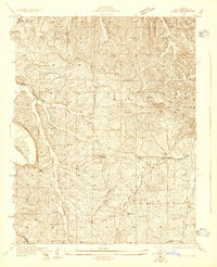
 1930 De Soto NE1930 Print · USGSJefferson County settlement and rural education are captured in the early 1930s as the railroad and river networks shaped the valley. Genealogists can locate family landmarks like Peter Moore Sch and Buckie Sch near the Victoria and De Soto corridors.
 - 1930 Map of Pacific SE
 1930 Pacific SE1930 Print · USGSJefferson County rural life in the early 1930s is captured here through its network of country schoolhouses and river valleys. Researchers can trace historic routes like Le May Ferry Road and find old settlements such as Belews and Goldman.2 unique versions available
End of results
Showing maps 1-2 of 2
Top cities near Joachim Township
- Oakville historical maps
- Arnold historical maps
- Festus historical maps
- Eureka historical maps
- Columbia historical maps
- Murphy historical maps
See more
Top neighborhoods of Joachim Township
- Mapaville historical maps
- Donnell historical maps
- Jarvis historical maps
- Hematite historical maps
- Horine historical maps
- Bushburg historical maps
See more
Frequently asked questions
- What are the different types of historical maps available for Joachim Township?
- What is the oldest map of Joachim Township?
- Where can I purchase historical maps of Joachim Township for my home or office?
- Where can I download high-res historical maps of Joachim Township?
- Are there historical topographic maps available for Joachim Township?
- Is there historical aerial imagery available for Joachim Township?
- Where are historical maps of Joachim Township sourced from?