1980s Maps of Joachim Township, Missouri
Explore 2 historic maps of Joachim Township from the 1980s. These maps offer a rare glimpse into what life looked like during the 1980s — showing old roads, neighborhoods, homes, and landmarks that have changed or disappeared over time.
Whether you're researching your family's past, planning a metal detecting trip, or studying how Joachim Township's landscape evolved across the 1980s, these high-resolution maps are a powerful tool for exploring the history of this region.
- Focus on a specific era: All maps on this page are from the 1980s, giving you a focused view of this time period.
- See what’s changed: Compare century-old streets, trails, and buildings to today's modern landscape using overlays and satellite layers.
- Research with precision: Use these maps for genealogy, historical research, land use analysis, or educational projects.
- View, download, or print: Maps are fully viewable online in high resolution, and can be downloaded or printed for your own records.
Start exploring Joachim Township's history through authentic maps from the 1980s. This is your window into the past.
Joachim Township, MO maps
(2)- 1981 Map of De Soto, 1982 Print
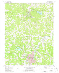 1981 De Soto1982 Print · USGSJefferson County’s landscape in the early eighties is captured here as the railroad town of De Soto and the hilltop county seat of Hillsboro expand. Genealogists and historians can trace family roots at Woodlawn Mem Park, the settlement at Victoria, and the Lone Pilgrim Ch.
 - 1985 Map of Festus, 1987 Print
 1985 Festus1987 Print · USGSThe Mississippi River corridor and Ozark foothills appear here in the mid-1980s, documenting a landscape of industrial river towns and forest preserves. Trace the development of Festus, Crystal City, and De Soto or locate sites like Mastodon State Park.
End of results
Showing maps 1-2 of 2
Top cities near Joachim Township
- Oakville historical maps
- Arnold historical maps
- Festus historical maps
- Eureka historical maps
- Columbia historical maps
- Murphy historical maps
See more
Top neighborhoods of Joachim Township
- Mapaville historical maps
- Donnell historical maps
- Jarvis historical maps
- Hematite historical maps
- Horine historical maps
- Bushburg historical maps
See more
Frequently asked questions
- What are the different types of historical maps available for Joachim Township?
- What is the oldest map of Joachim Township?
- Where can I purchase historical maps of Joachim Township for my home or office?
- Where can I download high-res historical maps of Joachim Township?
- Are there historical topographic maps available for Joachim Township?
- Is there historical aerial imagery available for Joachim Township?
- Where are historical maps of Joachim Township sourced from?