2000-2009 Maps of Laclede County, Missouri
Explore 8 historic maps of Laclede County from 2000-2009. These maps offer a rare glimpse into what life looked like during the 2000s — showing old roads, neighborhoods, homes, and landmarks that have changed or disappeared over time.
Whether you're researching your family's past, planning a metal detecting trip, or studying how Laclede County's landscape evolved across the 2000s, these high-resolution maps are a powerful tool for exploring the history of this region.
- Focus on a specific era: All maps on this page are from the 2000s, giving you a focused view of this time period.
- See what’s changed: Compare century-old streets, trails, and buildings to today's modern landscape using overlays and satellite layers.
- Research with precision: Use these maps for genealogy, historical research, land use analysis, or educational projects.
- View, download, or print: Maps are fully viewable online in high resolution, and can be downloaded or printed for your own records.
Start exploring Laclede County's history through authentic maps from the 2000s. This is your window into the past.
Laclede County, MO maps
(8)- 2004 Map of Bloodland, 2006 Print
 2004 Bloodland2006 Print · USGSPulaski County at the start of the millennium shows the intersection of the Mark Twain National Forest and expanding military grounds. Genealogists can locate family burial sites like Clark Cem and the former locations of Bloodland (Site) and Cookville (Site).
 - 2004 Map of Competition, 2006 Print
 2004 Competition2006 Print · USGSWright and Laclede Counties at the start of the new millennium show a landscape where conservation lands and the national forest meet the winding Gasconade River. Genealogists and local historians can trace rural routes like Jerktail Drive and Odell Road to find old cemeteries and the small settlements of Competition and St George.
 - 2004 Map of Roby, 2006 Print
 2004 Roby2006 Print · USGSTexas County at the start of the millennium shows the intersection of military training grounds and protected Ozark wilderness. Genealogists can locate family sites at Macedonia Cem or trace the early settlement footprints of Old Evening Shade and Plato.
 - 2004 Map of Drew, 2006 Print
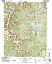
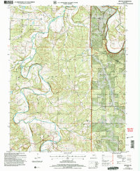
 2004 Drew2006 Print · USGSThe rural uplands of Laclede County are captured here in the early 2000s, showcasing a landscape of isolated farmsteads and dense timber. Researchers can trace family history through numerous landmarks like Moots Store, Delta Sch, and the Hamilton Cem.
 - 2004 Map of Manes, 2006 Print
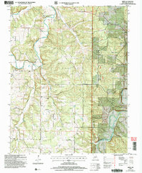
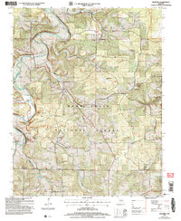
 2004 Manes2006 Print · USGSWright and Laclede counties are shown here as they appeared in the early 2000s, centered on the wooded plateaus of the Missouri Ozarks. Researchers can locate the Lynchburg CCC Camp, old family cemeteries, and rural crossroads like Mingsville and Manes.
 - 2004 Map of Drynob, 2006 Print
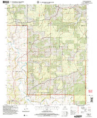
 2004 Drynob2006 Print · USGSLaclede and Pulaski counties are shown at the start of the new millennium as the Ozark landscape balances forest conservation with deep-rooted rural settlements. Genealogists can locate family landmarks like Rippy Cem, Abo, and former school locations such as Oakland Sch.
 - 2004 Map of Winnipeg, 2006 Print
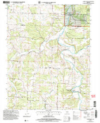
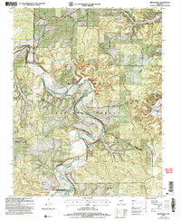
 2004 Winnipeg2006 Print · USGSLaclede County at the turn of the millennium shows a landscape shaped by the Gasconade River and the sprawling Mark Twain National Forest. Genealogists and local historians can trace former community hubs through sites like Nebo Sch (Site) and the Winnipeg Cem.
 - 2004 Map of Brownfield, 2006 Print
 2004 Brownfield2006 Print · USGSOzark life in the early 2000s is centered here on the Gasconade River and the forested ridges of Pulaski County. Genealogists and historians can trace family ties through Brownfield Cemetery, Jackson Cemetery, and local landmarks like the Fairview School.
End of results
Showing maps 1-8 of 8
Top cities of Laclede County
- Lebanon historical maps
- Conway historical maps
- Phillipsburg historical maps
- Evergreen historical maps
- Caffeyville historical maps
Frequently asked questions
- What are the different types of historical maps available for Laclede County?
- What is the oldest map of Laclede County?
- Where can I purchase historical maps of Laclede County for my home or office?
- Where can I download high-res historical maps of Laclede County?
- Are there historical topographic maps available for Laclede County?
- Is there historical aerial imagery available for Laclede County?
- Where are historical maps of Laclede County sourced from?