1940s Maps of Lexington, Missouri
Explore 2 historic maps of Lexington from the 1940s. These maps offer a rare glimpse into what life looked like during the 1940s — showing old roads, neighborhoods, homes, and landmarks that have changed or disappeared over time.
Whether you're researching your family's past, planning a metal detecting trip, or studying how Lexington's landscape evolved across the 1940s, these high-resolution maps are a powerful tool for exploring the history of this region.
- Focus on a specific era: All maps on this page are from the 1940s, giving you a focused view of this time period.
- See what’s changed: Compare century-old streets, trails, and buildings to today's modern landscape using overlays and satellite layers.
- Research with precision: Use these maps for genealogy, historical research, land use analysis, or educational projects.
- View, download, or print: Maps are fully viewable online in high resolution, and can be downloaded or printed for your own records.
Start exploring Lexington's history through authentic maps from the 1940s. This is your window into the past.
Lexington, MO maps
(2)- 1949 Map of Lexington East, 1963 Print
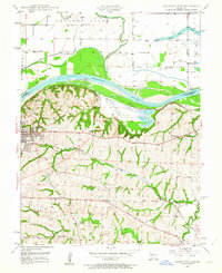 1949 Lexington East1963 Print · USGSLafayette County enters the post-war era as a hub of river commerce and rural education. Researchers can trace historic coal operations at various Mine Dumps or locate local landmarks like Wentworth Military Academy and the Slusher Sch.3 unique versions available
 - 1949 Map of Lexington West, 1963 Print
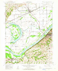 1949 Lexington West1963 Print · USGSThe Missouri River floodplain in the late 1940s reveals a complex network of rail lines and riverfront industry between Ray and Lafayette counties. Researchers can trace the river's influence through features like the Sunshine Lake oxbow, the Henrietta rail junction, and the Myrick riverfront.3 unique versions available
End of results
Showing maps 1-2 of 2
Top cities near Lexington
- Richmond historical maps
- Odessa historical maps
- Higginsville historical maps
- Norborne historical maps
- Wellington historical maps
- Hardin historical maps
See more
Frequently asked questions
- What are the different types of historical maps available for Lexington?
- What is the oldest map of Lexington?
- Where can I purchase historical maps of Lexington for my home or office?
- Where can I download high-res historical maps of Lexington?
- Are there historical topographic maps available for Lexington?
- Is there historical aerial imagery available for Lexington?
- Where are historical maps of Lexington sourced from?