1940s Maps of Lewis County, Missouri
Explore 9 historic maps of Lewis County from the 1940s. These maps offer a rare glimpse into what life looked like during the 1940s — showing old roads, neighborhoods, homes, and landmarks that have changed or disappeared over time.
Whether you're researching your family's past, planning a metal detecting trip, or studying how Lewis County's landscape evolved across the 1940s, these high-resolution maps are a powerful tool for exploring the history of this region.
- Focus on a specific era: All maps on this page are from the 1940s, giving you a focused view of this time period.
- See what’s changed: Compare century-old streets, trails, and buildings to today's modern landscape using overlays and satellite layers.
- Research with precision: Use these maps for genealogy, historical research, land use analysis, or educational projects.
- View, download, or print: Maps are fully viewable online in high resolution, and can be downloaded or printed for your own records.
Start exploring Lewis County's history through authentic maps from the 1940s. This is your window into the past.
Lewis County, MO maps
(9)- 1944 Map of Quincy, 1954 Print
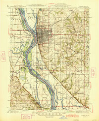
 1944 Quincy1954 Print · USGSQuincy and the Mississippi River valley are captured in the 1940s, showing a landscape defined by rail lines and rural parish schools. Researchers can trace the riverfront at Marion City, the grounds of the Soldiers Home, and historic sites like Zion Church.5 unique versions available
 - 1945 Map of Quincy
 1945 Quincy1945 Print · USGSQuincy and its Mississippi River crossings are captured here in the mid-1940s during a period of transition for its riverfront and rail lines. Genealogists can trace family roots at local landmarks like the Soldiers Home, Melrose Chapel, and numerous rural schoolhouses such as Hickory Grove School.2 unique versions available
 - 1946 Map of Mendon, 1958 Print
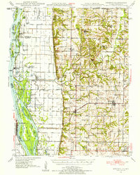 1946 Mendon1958 Print · USGSThe fertile bottomlands of Adams County are seen here in the mid-1940s, as massive drainage projects reshaped the Mississippi River's eastern bank. Genealogists can locate family names and sites through numerous rural landmarks like Wesley Chapel Cem, Gentry Sch, and the Canton Ferry.
 - 1948 Map of Quincy
 1948 Quincy1948 Print · USGSThe Mississippi and Illinois River valleys are captured at a post-war crossroads as rail and river travel met the expanding highway system. Genealogists can trace family settlements from Quincy to Hannibal and smaller towns like Vandalia and Jerseyville.2 unique versions available
 - 1948 Map of Mendon
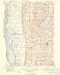 1948 Mendon1948 Print · USGSUpper Adams County in the late 1940s reveals a landscape defined by Mississippi River engineering and tight-knit rural communities. Researchers can trace ancestral locations at New Providence Cem, several dozen one-room schoolhouses like Golden Sch, and the winding Bear Creek drainage.2 unique versions available
 - 1949 Map of Durham, 1956 Print
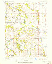
 1949 Durham1956 Print · USGSMarion and Lewis counties are captured here just after the war, showing the rural rail-and-river network of northern Missouri. Researchers can trace family sites near Emerson, find the Mount Sinai Ch, and locate family plots like Wagner Cem.2 unique versions available
 - 1949 Map of Maywood, 1956 Print
 1949 Maywood1956 Print · USGSNortheast Missouri’s river-bottom lands are shown here in the late 1940s as the rail and river networks shaped local life. Researchers can locate vanished landmarks like Shannon Sch, Olivet Ch, and family-named cemeteries including Maywood Cem.2 unique versions available
 - 1949 Map of Kahoka SE, 1963 Print
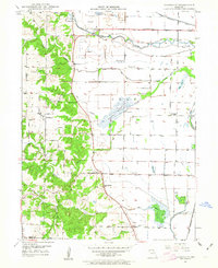 1949 Kahoka SE1963 Print · USGSNortheastern Missouri farmland meets the winding Fox River in this mid-century survey of Clark and Lewis Counties. Genealogists and local historians can trace rural school districts like Lone Star Sch and locate family burial sites at Mt Zion Cem and St Patrick Cem.2 unique versions available
 - 1949 Map of St. Patrick, 1977 Print
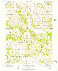
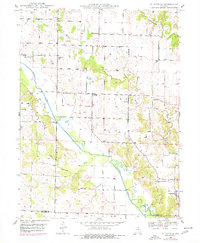 1949 St. Patrick1977 Print · USGSNortheast Missouri’s rural landscape is captured here at mid-century, just as the network of one-room country schools began to fade. Genealogists can locate family landmarks like the Pride of the West Sch, Honey Creek Cem, and the village of St Patrick.
End of results
Showing maps 1-9 of 9
Top cities of Lewis County
- Canton historical maps
- La Grange historical maps
- La Belle historical maps
- Lewistown historical maps
- Ewing historical maps
- Monticello historical maps
Frequently asked questions
- What are the different types of historical maps available for Lewis County?
- What is the oldest map of Lewis County?
- Where can I purchase historical maps of Lewis County for my home or office?
- Where can I download high-res historical maps of Lewis County?
- Are there historical topographic maps available for Lewis County?
- Is there historical aerial imagery available for Lewis County?
- Where are historical maps of Lewis County sourced from?