1940s Maps of McDonald County, Missouri
Explore 6 historic maps of McDonald County from the 1940s. These maps offer a rare glimpse into what life looked like during the 1940s — showing old roads, neighborhoods, homes, and landmarks that have changed or disappeared over time.
Whether you're researching your family's past, planning a metal detecting trip, or studying how McDonald County's landscape evolved across the 1940s, these high-resolution maps are a powerful tool for exploring the history of this region.
- Focus on a specific era: All maps on this page are from the 1940s, giving you a focused view of this time period.
- See what’s changed: Compare century-old streets, trails, and buildings to today's modern landscape using overlays and satellite layers.
- Research with precision: Use these maps for genealogy, historical research, land use analysis, or educational projects.
- View, download, or print: Maps are fully viewable online in high resolution, and can be downloaded or printed for your own records.
Start exploring McDonald County's history through authentic maps from the 1940s. This is your window into the past.
McDonald County, MO maps
(6)- 1940 Map of Noel, 1955 Print
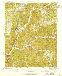 1940 Noel1955 Print · USGSSouthwest Missouri's river valleys and ridge-top communities are captured here just before the war, as the Kansas City Southern rail line connected the Ozark hills. Genealogists can trace family footprints through numerous local landmarks like Indian Springs Sch, Sugar Beach Cem, and the Riverside Inn.2 unique versions available
 - 1941 Map of Rocky Comfort, 1962 Print
 1941 Rocky Comfort1962 Print · USGSThe Missouri Ozarks are captured here in the early 1940s, showing a landscape defined by the winding Big Sugar Creek and the Missouri and Arkansas railroad. Researchers can trace rural life through dozens of local sites like Chitwood Cem, Rocky Comfort, and the Spring Hill Sch.2 unique versions available
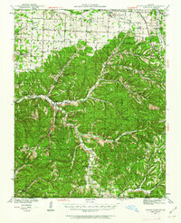
 - 1943 Map of Ritchey
 1943 Ritchey1943 Print · USGSSouthwest Missouri during the war years shows a landscape of busy railroads and emerging military sites. Genealogists can trace family roots through numerous local landmarks like Odd Fellows Cem, Dungy Mine, and rural centers such as Stark City.2 unique versions available
 - 1943 Map of Noel
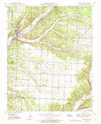
 1943 Noel1943 Print · USGSThe Ozark river valleys of McDonald County are shown here in the early 1940s, just as the regional highway network was expanding. Genealogists can trace family names through dozens of rural landmarks like Bannock Cem, Christian Ch, and Moss Sch.2 unique versions available
 - 1943 Map of Rocky Comfort
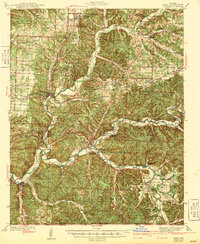
 1943 Rocky Comfort1943 Print · USGSThe Ozark highlands of McDonald County come into sharp focus during the early 1940s, showing a landscape of deep hollows and high ridges. Genealogists can trace family roots through numerous rural landmarks like Seven Star Sch, Greason Cem, and the village of Powell.3 unique versions available
 - 1949 Map of Seneca, 1970 Print
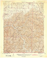
 1949 Seneca1970 Print · USGSNewton County life in the late 1940s is centered on the town of Seneca and its proximity to the Oklahoma border. Genealogists can trace family footprints across several rural landmarks, including Gallemore Sch, Graves Cem, and Swars Prairie Baptist Ch.2 unique versions available
End of results
Showing maps 1-6 of 6
Top cities of McDonald County
- Anderson historical maps
- Noel historical maps
- Goodman historical maps
- Southwest City historical maps
- Pineville historical maps
- Lanagan historical maps
See more
Frequently asked questions
- What are the different types of historical maps available for McDonald County?
- What is the oldest map of McDonald County?
- Where can I purchase historical maps of McDonald County for my home or office?
- Where can I download high-res historical maps of McDonald County?
- Are there historical topographic maps available for McDonald County?
- Is there historical aerial imagery available for McDonald County?
- Where are historical maps of McDonald County sourced from?