1950s Maps of McDonald County, Missouri
Explore 4 historic maps of McDonald County from the 1950s. These maps offer a rare glimpse into what life looked like during the 1950s — showing old roads, neighborhoods, homes, and landmarks that have changed or disappeared over time.
Whether you're researching your family's past, planning a metal detecting trip, or studying how McDonald County's landscape evolved across the 1950s, these high-resolution maps are a powerful tool for exploring the history of this region.
- Focus on a specific era: All maps on this page are from the 1950s, giving you a focused view of this time period.
- See what’s changed: Compare century-old streets, trails, and buildings to today's modern landscape using overlays and satellite layers.
- Research with precision: Use these maps for genealogy, historical research, land use analysis, or educational projects.
- View, download, or print: Maps are fully viewable online in high resolution, and can be downloaded or printed for your own records.
Start exploring McDonald County's history through authentic maps from the 1950s. This is your window into the past.
McDonald County, MO maps
(4)- 1950 Map of Seneca
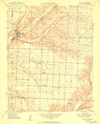 1950 Seneca1950 Print · USGSNewton County at the Missouri-Oklahoma line is shown here at mid-century, where the rail-linked town of Seneca meets the mineral-rich hills. Researchers can trace rural landmarks including the Tripoli Mine, Westview Sch, and Hollow Springs Ch.2 unique versions available
 - 1954 Map of Tulsa
 1954 Tulsa1954 Print · USGSNortheast Oklahoma and the Ozark border are shown here during a period of massive industrial and infrastructure growth. Researchers can trace the legacy of the Tri-State Mining District and the development of major reservoirs like Grand Lake O' The Cherokees.2 unique versions available
 - 1958 Map of Pea Ridge, 1959 Print
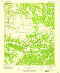 1958 Pea Ridge1959 Print · USGSBenton County, Arkansas, at the end of the 1950s reveals a rural landscape still anchored by its nineteenth-century history. Researchers can locate dozens of family burial sites and country churches, such as Buttrum Cem and Twelve Corners Ch, alongside the landmark Elkhorn Tavern.4 unique versions available
 - 1958 Map of Tulsa, 1968 Print
 1958 Tulsa1968 Print · USGSNortheast Oklahoma and the Ozark borderlands are captured here during a massive era of reservoir construction and highway expansion. Researchers can trace the mid-century footprints of Tulsa, the sprawling Lake O' the Cherokees, and historical sites like Pea Ridge National Military Park.3 unique versions available
End of results
Showing maps 1-4 of 4
Top cities of McDonald County
- Anderson historical maps
- Noel historical maps
- Goodman historical maps
- Southwest City historical maps
- Pineville historical maps
- Lanagan historical maps
See more
Frequently asked questions
- What are the different types of historical maps available for McDonald County?
- What is the oldest map of McDonald County?
- Where can I purchase historical maps of McDonald County for my home or office?
- Where can I download high-res historical maps of McDonald County?
- Are there historical topographic maps available for McDonald County?
- Is there historical aerial imagery available for McDonald County?
- Where are historical maps of McDonald County sourced from?