1950s Maps of Mississippi County, Missouri
Explore 19 historic maps of Mississippi County from the 1950s. These maps offer a rare glimpse into what life looked like during the 1950s — showing old roads, neighborhoods, homes, and landmarks that have changed or disappeared over time.
Whether you're researching your family's past, planning a metal detecting trip, or studying how Mississippi County's landscape evolved across the 1950s, these high-resolution maps are a powerful tool for exploring the history of this region.
- Focus on a specific era: All maps on this page are from the 1950s, giving you a focused view of this time period.
- See what’s changed: Compare century-old streets, trails, and buildings to today's modern landscape using overlays and satellite layers.
- Research with precision: Use these maps for genealogy, historical research, land use analysis, or educational projects.
- View, download, or print: Maps are fully viewable online in high resolution, and can be downloaded or printed for your own records.
Start exploring Mississippi County's history through authentic maps from the 1950s. This is your window into the past.
Mississippi County, MO maps
(19)- 1950 Map of Paducah
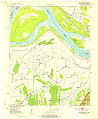
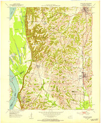
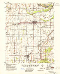
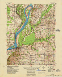
 1950 Paducah1950 Print · USGSThe confluence of the great midwestern rivers defines this mid-century landscape at the intersection of Illinois, Kentucky, and Missouri. Genealogists and historians can trace the rail-and-river economy through the hubs of Paducah, Cairo, and Metropolis or locate family roots near the Wildcat Hills.
 - 1951 Map of Bondurant, 1952 Print
 1951 Bondurant1952 Print · USGSThe Kentucky-Tennessee borderlands and the Mississippi River bottoms are captured here during the early fifties. Genealogists and historians can trace the Illinois Central rail line through rural hubs like Bondurant, Sassafras Ridge, and Tyler.
 - 1951 Map of Hickman, 1953 Print
 1951 Hickman1953 Print · USGSThe river bluffs at Hickman overlook a complex tri-state landscape during the early 1950s. Genealogists and local historians can trace the foundations of rural Kentucky and Missouri life through landmarks like Dorena Sch, Poplar Grove Ch, and the Illinois Central railroad lines.
 - 1951 Map of Wolf Island, 1953 Print
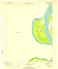
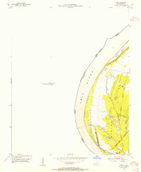
 1951 Wolf Island1953 Print · USGSThe Mississippi River floodplain at the Kentucky-Missouri border is captured here in the early fifties, showing a landscape shaped by shifting currents. Researchers can trace the mid-century channel and landforms like Wolf Island No 5, Medley Bar, and the banks near Chalk Bluff.2 unique versions available
 - 1951 Map of Wickliffe SW, 1953 Print
 1951 Wickliffe SW1953 Print · USGSThe Kentucky and Missouri borderlands along the Mississippi are captured here in the early fifties. River historians and researchers can trace the shifting banks of Lucas Bend and the precise boundaries of Islands Nos 2 3 & 4 and Wolf Island No 5.3 unique versions available
 - 1951 Map of Arlington, 1953 Print
 1951 Arlington1953 Print · USGSWestern Kentucky's river bluffs and bottomlands are frozen in time during the early fifties, showing the region's transition from the Mississippi floodplain to upland farms. Researchers can trace family history at Roselawn Cem, locate the Trevathan Sch, or explore the grounds of Columbus-Belmont State Park.2 unique versions available
 - 1951 Map of Wickliffe, 1953 Print
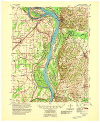
 1951 Wickliffe1953 Print · USGSThe river confluence at the Kentucky-Missouri border comes to life in the early fifties, showing the strategic rail and water hub around Wickliffe. Researchers can locate old family landmarks like Harrison Hughes Cem or trace the early paths of the Illinois Central railroad.2 unique versions available
 - 1952 Map of Wickliffe, 1964 Print
 1952 Wickliffe1964 Print · USGSThe confluence of the Ohio and Mississippi rivers in the early fifties shows a bustling network of river commerce and rail lines. You can trace family roots through numerous rural landmarks like North Ballard Ch & Cem, Birds Point Sch, and the rail junction at Winford Junction.
 - 1953 Map of Cairo, 1959 Print
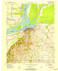
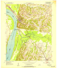
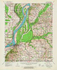
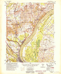
 1953 Cairo1959 Print · USGSThe confluence of the Ohio and Mississippi Rivers is captured here in the mid-1950s, showing a landscape defined by floodgates and rail lines. Researchers can trace the layout of Cairo, find family plots at Hazelwood Cem, or locate landmarks like the National Cemetery and Cairo Airport.3 unique versions available
 - 1954 Map of Charleston
 1954 Charleston1954 Print · USGSSoutheastern Missouri's river country is captured here during the mid-1950s, showing the complex drainage systems of the Bootheel. Researchers can locate dozens of rural landmarks like Bridges Ch & Sch, Maynard Cem, and the Missouri Pacific line.2 unique versions available
 - 1954 Map of Paducah
 1954 Paducah1954 Print · USGSSouthern Illinois and Western Kentucky intersect at the great river confluences during this mid-century era of rail and river industry. Genealogists and historians can trace family roots and commerce through river towns like Cairo, Metropolis, and Golconda, or along the tracks of the Illinois Central Railroad.2 unique versions available
 - 1954 Map of Cairo, 1955 Print
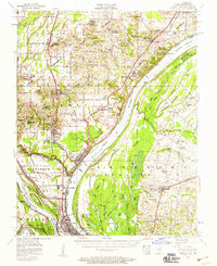
 1954 Cairo1955 Print · USGSThe Kentucky side of the Ohio River in the mid-1950s reveals a landscape defined by the wetlands and sloughs of the BARLOW BOTTOMS. Genealogists and local historians can trace the paths of the GULF CENTRAL MOBILE AND OHIO RAILROAD near East Cairo and the unique topography of Twin Mounds.
 - 1954 Map of Hickman, 1966 Print
 1954 Hickman1966 Print · USGSThe tristate river country of Kentucky, Missouri, and Tennessee is captured here during the mid-century era of river control and rural rail. Genealogists can trace family landmarks like Sylvan Shade Sch, Dorena, and the river landings at Williams Ldg.
 - 1955 Map of Thebes
 1955 Thebes1955 Print · USGSThe Illinois riverfront near the confluence of the Mississippi and Cache rivers shows a landscape of timber and rail in the mid-1950s. Genealogists and historians can trace family locations near Richwood Cem, the junction at Thebes, and remote rural schoolhouses like Owensby Sch.
 - 1955 Map of Hickman
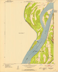
 1955 Hickman1955 Print · USGSMid-century life along the Mississippi River meanders is captured here during a period of heavy river engineering and rural expansion. Genealogists can trace family names and local sites like Sassafras Ridge Cem, Dorena Ch, and the Illinois Central rail line.2 unique versions available
 - 1955 Map of Bayouville
 1955 Bayouville1955 Print · USGSThe river bottomlands of the Missouri-Kentucky border are shown in the mid-1950s as a landscape of intensive levee engineering and rural community nodes. Researchers can locate many now-obscure sites like Henderson Mound, Barnes Ridge Ch, and the school at Madrid Bend.
 - 1955 Map of Wickliffe
 1955 Wickliffe1955 Print · USGSThe confluence of the great river systems at the Kentucky-Missouri-Illinois border is documented here in the mid-fifties. Researchers can locate vanished rural landmarks and river landings like Norfolk Ldg, Thirty Four Corner Sch, and the Mississippi Ch & Cem.
 - 1955 Map of Cairo
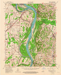
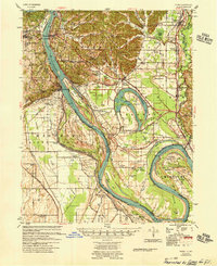
 1955 Cairo1955 Print · USGSThe confluence of the great rivers at the southern tip of Illinois is captured here in the mid-1950s. Trace the vital rail hubs of Cairo, explore the grounds of the National Cemetery, and locate vanished rural schools like America Sch and Bryan Sch.
 - 1956 Map of Dyersburg, 1960 Print
 1956 Dyersburg1960 Print · USGSThe Four Rivers region comes alive in the mid-fifties, capturing the intricate borderlands of Tennessee, Kentucky, and Missouri. Genealogists and historians can trace the rail-and-river networks connecting Dyersburg, Caruthersville, and the shoreline of Reelfoot Lake.4 unique versions available
End of results
Showing maps 1-19 of 19
Top cities of Mississippi County
- Charleston historical maps
- East Prairie historical maps
- Bertrand historical maps
- Wyatt historical maps
- Anniston historical maps
- Wilson City historical maps
See more
Frequently asked questions
- What are the different types of historical maps available for Mississippi County?
- What is the oldest map of Mississippi County?
- Where can I purchase historical maps of Mississippi County for my home or office?
- Where can I download high-res historical maps of Mississippi County?
- Are there historical topographic maps available for Mississippi County?
- Is there historical aerial imagery available for Mississippi County?
- Where are historical maps of Mississippi County sourced from?