1990s Maps of Mississippi County, Missouri
Explore 3 historic maps of Mississippi County from the 1990s. These maps offer a rare glimpse into what life looked like during the 1990s — showing old roads, neighborhoods, homes, and landmarks that have changed or disappeared over time.
Whether you're researching your family's past, planning a metal detecting trip, or studying how Mississippi County's landscape evolved across the 1990s, these high-resolution maps are a powerful tool for exploring the history of this region.
- Focus on a specific era: All maps on this page are from the 1990s, giving you a focused view of this time period.
- See what’s changed: Compare century-old streets, trails, and buildings to today's modern landscape using overlays and satellite layers.
- Research with precision: Use these maps for genealogy, historical research, land use analysis, or educational projects.
- View, download, or print: Maps are fully viewable online in high resolution, and can be downloaded or printed for your own records.
Start exploring Mississippi County's history through authentic maps from the 1990s. This is your window into the past.
Mississippi County, MO maps
(3)- 1993 Map of Cairo, 1996 Print
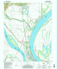 1993 Cairo1996 Print · USGSThe confluence of the Ohio and Mississippi rivers is captured in the 1990s, showing the strategic riverfront of Cairo and its surrounding levee systems. Genealogists and researchers can trace the detailed grids of Mound City and Mounds, or locate family sites near the Mound City National Cem and Thistlewood Cemetery.
 - 1993 Map of Cache, 1996 Print
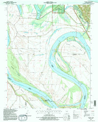 1993 Cache1996 Print · USGSThe bottomlands of Alexander County are captured here in the early nineties, showing a landscape defined by the shifting Mississippi River. Researchers can locate family landmarks like Schendler Cem and Thompson Cem or trace the river's path around Sister Island.
 - 1993 Map of Charleston, 1996 Print
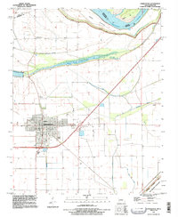 1993 Charleston1996 Print · USGSCharleston sits at the edge of the Mississippi floodplains in the 1990s, surrounded by a massive protective levee system. Researchers can trace family history at Texas Bend Cem and Lee Cem or locate the Indian Mound and Big Lake.
End of results
Showing maps 1-3 of 3
Top cities of Mississippi County
- Charleston historical maps
- East Prairie historical maps
- Bertrand historical maps
- Wyatt historical maps
- Anniston historical maps
- Wilson City historical maps
See more
Frequently asked questions
- What are the different types of historical maps available for Mississippi County?
- What is the oldest map of Mississippi County?
- Where can I purchase historical maps of Mississippi County for my home or office?
- Where can I download high-res historical maps of Mississippi County?
- Are there historical topographic maps available for Mississippi County?
- Is there historical aerial imagery available for Mississippi County?
- Where are historical maps of Mississippi County sourced from?