1970s Maps of Mississippi County, Missouri
Explore 6 historic maps of Mississippi County from the 1970s. These maps offer a rare glimpse into what life looked like during the 1970s — showing old roads, neighborhoods, homes, and landmarks that have changed or disappeared over time.
Whether you're researching your family's past, planning a metal detecting trip, or studying how Mississippi County's landscape evolved across the 1970s, these high-resolution maps are a powerful tool for exploring the history of this region.
- Focus on a specific era: All maps on this page are from the 1970s, giving you a focused view of this time period.
- See what’s changed: Compare century-old streets, trails, and buildings to today's modern landscape using overlays and satellite layers.
- Research with precision: Use these maps for genealogy, historical research, land use analysis, or educational projects.
- View, download, or print: Maps are fully viewable online in high resolution, and can be downloaded or printed for your own records.
Start exploring Mississippi County's history through authentic maps from the 1970s. This is your window into the past.
Mississippi County, MO maps
(6)- 1970 Map of Arlington, 1972 Print
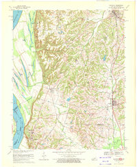 1970 Arlington1972 Print · USGSThe Mississippi River bluffs and Carlisle County uplands are captured here in the 1970s. Trace family history through rural sites like Webbs Chapel, Rogers Cem, and Allen Cem, or follow the path of the Gulf Mobile and Ohio railroad.3 unique versions available
 - 1970 Map of Hickman, 1972 Print
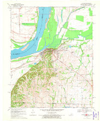 1970 Hickman1972 Print · USGSThe riverfront at Hickman and the surrounding Kentucky-Tennessee borderlands are shown here during the early seventies. Genealogists and local historians can trace family sites at Hubbard Cem, visit Anna Lynne, or follow the Illinois Central Railroad line.2 unique versions available
 - 1970 Map of Wickliffe, 1972 Print
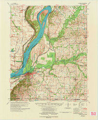
 1970 Wickliffe1972 Print · USGSThe river bluffs of western Kentucky met the great confluence in the 1970s, where the Missouri and Illinois borders converge. Genealogists and historians can trace significant landmarks like the Ancient Buried City, the Site of Fort Jefferson, and the Wickliffe Cem.2 unique versions available
 - 1972 Map of Bayouville
 1972 Bayouville1972 Print · USGSThe tri-state river country of Missouri, Kentucky, and Tennessee is mapped here in the early seventies as a land of massive river bends and ancient mounds. Researchers can trace historic earthworks at Corner Stone Indian Mound, find rural burials at Cole Cem, and locate settlements like Dorena and Farrenburg.
 - 1972 Map of Wickliffe
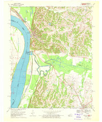
 1972 Wickliffe1972 Print · USGSThe confluence of the Ohio and Mississippi Rivers is captured here in the early seventies, showing a landscape defined by major levees and river commerce. Genealogists can trace family landmarks like Bird Cem and Birds Point Sch or the riverside town of Wickliffe.
 - 1972 Map of Hickman
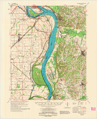
 1972 Hickman1972 Print · USGSThe Kentucky and Tennessee borderlands come alive in the early 1970s, as the mighty Mississippi winds past riverfront settlements. Researchers can trace the Illinois Central rail line through rural hubs like Moscow and Cayce, or locate family landmarks such as Mt Hermon Ch and Ivie Cem.
End of results
Showing maps 1-6 of 6
Top cities of Mississippi County
- Charleston historical maps
- East Prairie historical maps
- Bertrand historical maps
- Wyatt historical maps
- Anniston historical maps
- Wilson City historical maps
See more
Frequently asked questions
- What are the different types of historical maps available for Mississippi County?
- What is the oldest map of Mississippi County?
- Where can I purchase historical maps of Mississippi County for my home or office?
- Where can I download high-res historical maps of Mississippi County?
- Are there historical topographic maps available for Mississippi County?
- Is there historical aerial imagery available for Mississippi County?
- Where are historical maps of Mississippi County sourced from?