1970s Maps of High Hill, Missouri
Explore 4 historic maps of High Hill from the 1970s. These maps offer a rare glimpse into what life looked like during the 1970s — showing old roads, neighborhoods, homes, and landmarks that have changed or disappeared over time.
Whether you're researching your family's past, planning a metal detecting trip, or studying how High Hill's landscape evolved across the 1970s, these high-resolution maps are a powerful tool for exploring the history of this region.
- Focus on a specific era: All maps on this page are from the 1970s, giving you a focused view of this time period.
- See what’s changed: Compare century-old streets, trails, and buildings to today's modern landscape using overlays and satellite layers.
- Research with precision: Use these maps for genealogy, historical research, land use analysis, or educational projects.
- View, download, or print: Maps are fully viewable online in high resolution, and can be downloaded or printed for your own records.
Start exploring High Hill's history through authentic maps from the 1970s. This is your window into the past.
High Hill, MO maps
(4)- 1973 Map of Pinnacle Lake, 1975 Print
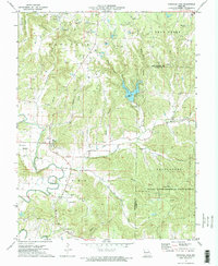 1973 Pinnacle Lake1975 Print · USGSMontgomery County in the early 1970s reveals a landscape defined by the clay mining industry and the waters of Pinnacle Lake. Genealogists and historians can trace numerous rural family burial sites including Snethen Cem and Loutre Island Cem.2 unique versions available
 - 1973 Map of New Florence, 1975 Print
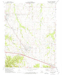 1973 New Florence1975 Print · USGSThe mid-Missouri countryside near New Florence is captured here in the early seventies during a period of industrial and rural transition. Local researchers can locate specific claypits, family-linked sites like Mt Pleasant Cem, and the path of the Norfolk and Western railroad.
 - 1973 Map of Bellflower South, 1975 Print
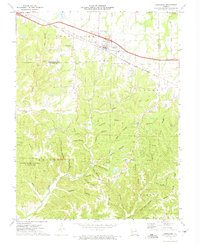
 1973 Bellflower South1975 Print · USGSEastern Missouri's rural landscape is captured here in the early seventies, showing a network of small settlements and creek-bottom farms. Researchers can trace family history through sites like St Paul Cem, the Baptist Cem of Bellflower, and the old rail line of the Burlington Northern.
 - 1973 Map of Jonesburg, 1975 Print
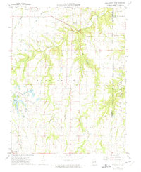
 1973 Jonesburg1975 Print · USGSIn the early 1970s, the rural landscapes of Montgomery and Warren counties were defined by the Norfolk and Western railroad and industrial sites. Researchers can trace family history through sites like Bolton Cem or explore the geography of Daniel Boone Memorial State Forest and its numerous claypits.2 unique versions available
End of results
Showing maps 1-4 of 4
Top cities near High Hill
- Warrenton historical maps
- Hermann historical maps
- Montgomery City historical maps
- Wellsville historical maps
- New Florence historical maps
- Jonesburg historical maps
See more
Frequently asked questions
- What are the different types of historical maps available for High Hill?
- What is the oldest map of High Hill?
- Where can I purchase historical maps of High Hill for my home or office?
- Where can I download high-res historical maps of High Hill?
- Are there historical topographic maps available for High Hill?
- Is there historical aerial imagery available for High Hill?
- Where are historical maps of High Hill sourced from?