1930s Maps of Osage County, Missouri
Explore 5 historic maps of Osage County from the 1930s. These maps offer a rare glimpse into what life looked like during the 1930s — showing old roads, neighborhoods, homes, and landmarks that have changed or disappeared over time.
Whether you're researching your family's past, planning a metal detecting trip, or studying how Osage County's landscape evolved across the 1930s, these high-resolution maps are a powerful tool for exploring the history of this region.
- Focus on a specific era: All maps on this page are from the 1930s, giving you a focused view of this time period.
- See what’s changed: Compare century-old streets, trails, and buildings to today's modern landscape using overlays and satellite layers.
- Research with precision: Use these maps for genealogy, historical research, land use analysis, or educational projects.
- View, download, or print: Maps are fully viewable online in high resolution, and can be downloaded or printed for your own records.
Start exploring Osage County's history through authentic maps from the 1930s. This is your window into the past.
Osage County, MO maps
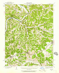
(5)- 1934 Map of Linn
 1934 Linn1934 Print · USGSThe Osage County hills and river valleys are shown in detail during the 1930s, featuring the early networks of rural schools and family cemeteries. Genealogists can trace family names and locations at Van Buren Cem, Mt Calvary Ch, and Rich Fountain.
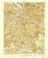
 - 1934 Map of Bland, 1959 Print
 1934 Bland1959 Print · USGSMid-Missouri's ridge-and-hollow country is captured in the 1930s as the rail line drove the development of the Gasconade and Osage county borders. Researchers can locate dozens of country schools and churches like Cleavesville Sch, New Bethel Ch, and College Hill Cem.2 unique versions available
 - 1935 Map of Morrison
 1935 Morrison1935 Print · USGSThe confluence of the Missouri and Gasconade rivers comes to life in the mid-1930s, showing a world of river-town commerce and rural homesteads. Trace ancestral roots at Townley Cem, find old river crossings like Feiglers Ferry, or locate the Mint Hill PO.
 - 1937 Map of Bland
 1937 Bland1937 Print · USGSMid-Missouri river bluffs and rail towns come to life in this mid-century survey of Gasconade and Maries counties. Local historians can trace the shift from river fords like Valentine Ford to the rail corridor connecting Belle, Bland, and Owensville.2 unique versions available
 - 1939 Map of Jefferson City, 1954 Print
 1939 Jefferson City1954 Print · USGSMissouri's capital and the surrounding river bluffs are captured here in the late thirties, showing the region's transition between rural farmland and state governance. Researchers can locate family landmarks like Providence Cem, the Algoa Reformatory, and various schools such as Sycamore Sch.2 unique versions available
End of results
Showing maps 1-5 of 5
Top cities of Osage County
- Linn historical maps
- Chamois historical maps
- Freeburg historical maps
- Westphalia historical maps
- Meta historical maps
Frequently asked questions
- What are the different types of historical maps available for Osage County?
- What is the oldest map of Osage County?
- Where can I purchase historical maps of Osage County for my home or office?
- Where can I download high-res historical maps of Osage County?
- Are there historical topographic maps available for Osage County?
- Is there historical aerial imagery available for Osage County?
- Where are historical maps of Osage County sourced from?