1980s Maps of Osage County, Missouri
Explore 14 historic maps of Osage County from the 1980s. These maps offer a rare glimpse into what life looked like during the 1980s — showing old roads, neighborhoods, homes, and landmarks that have changed or disappeared over time.
Whether you're researching your family's past, planning a metal detecting trip, or studying how Osage County's landscape evolved across the 1980s, these high-resolution maps are a powerful tool for exploring the history of this region.
- Focus on a specific era: All maps on this page are from the 1980s, giving you a focused view of this time period.
- See what’s changed: Compare century-old streets, trails, and buildings to today's modern landscape using overlays and satellite layers.
- Research with precision: Use these maps for genealogy, historical research, land use analysis, or educational projects.
- View, download, or print: Maps are fully viewable online in high resolution, and can be downloaded or printed for your own records.
Start exploring Osage County's history through authentic maps from the 1980s. This is your window into the past.
Osage County, MO maps
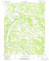
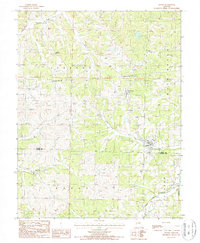
(14)- 1981 Map of Freeburg
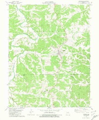 1981 Freeburg1981 Print · USGSFreeburg and the surrounding Ozark foothills are captured here in the early eighties as a network of rural roads and family hollows. Genealogists and local historians can trace landmarks like Holy Family Cem, the Maries River, and old Kilns near the county line.
 - 1981 Map of Belle
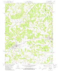 1981 Belle1981 Print · USGSThe tri-county borderlands of Maries, Gasconade, and Osage Counties come alive in this early 1980s survey of the Missouri uplands. Local historians can trace the network of clay mining and rural life through landmarks like Beulah Ch and numerous family plots such as Backues Cem and Heyer Cem.
 - 1981 Map of Cooper Hill
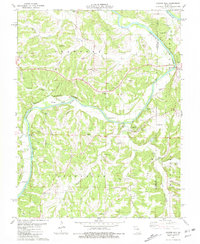 1981 Cooper Hill1981 Print · USGSOsage and Gasconade counties are documented here in the early eighties, centered on the winding river corridor. Genealogists can trace family names through dozens of rural landmarks, including the Fuersville Cem, Mt Sterling, and the College Hill Ch.
 - 1981 Map of Westphalia East
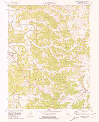 1981 Westphalia East1981 Print · USGSOsage County's river-carved valleys and upland ridges are captured in the early 1980s as rural life centered on the Maries River. Genealogists and historians can trace family sites at Sacred Heart Cem or locate industrial markers like the Shale Pit and Kilns.
 - 1981 Map of Summerfield
 1981 Summerfield1981 Print · USGSThe Gasconade River breaks through Osage and Maries counties in the early 1980s, revealing a landscape of limestone bluffs and rural settlements. Genealogists and historians can trace family locations at Summerfield, the Pilot Knob Ch, and Branson Cemetery.
 - 1981 Map of Linn
 1981 Linn1981 Print · USGSIn the early 1980s, the area around Linn was a blend of academic growth and deep rural history. You can trace family lineages at the Wash Branson Cem, explore the riverfront at Rollins Ferry Public Access Area, or locate the old community of Potts.
 - 1982 Map of Jefferson City, 1983 Print
 1982 Jefferson City1983 Print · USGSMid-Missouri in the early eighties shows the corridor between Columbia and Jefferson City during a period of modern growth. Genealogists and historians can trace the Missouri Pacific Railroad route, family plots at Memorial Park Cem, and landmarks like Osage City and Lupus.
 - 1983 Map of Lake Of The Ozarks, 1984 Print
 1983 Lake Of The Ozarks1984 Print · USGSThe Lake of the Ozarks region in the early eighties shows a landscape of deep river bends and growing recreation. Genealogists can trace family names and small settlements from Versailles to Meta and locate old mining sites like Tiff Mine.
 - 1985 Map of Sullivan
 1985 Sullivan1985 Print · USGSMid-1980s Missouri comes into focus here as the Ozark landscape balances industrial mining with river recreation. Genealogists and historians can trace the St Louis-San Francisco RR through Sullivan and locate landmarks like Pea Ridge Mine or St Cloud Church.3 unique versions available
 - 1985 Map of Fulton
 1985 Fulton1985 Print · USGSMid-Missouri was a hub of river commerce and rail travel in the mid-1980s, where towns like Fulton and Hermann anchored the river valley. Researchers can trace historic river islands like Rush Island or follow the path of the Missouri - Kansas - Texas Railroad.2 unique versions available
 - 1987 Map of Westphalia West, 1988 Print
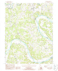
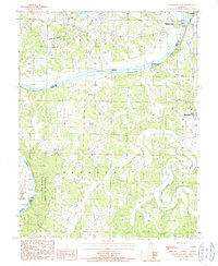 1987 Westphalia West1988 Print · USGSOsage and Cole Counties are shown in the late eighties as the winding Osage River dominates the local geography. Researchers can trace historic industrial sites like the Coke Ovens or locate family roots near Folk Cem and Westphalia.
 - 1987 Map of Meta, 1988 Print
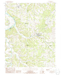 1987 Meta1988 Print · USGSOsage and Cole counties in the mid-1980s reveal a landscape of river-bottom commerce and hilltop communication towers. Researchers can trace the winding Osage River past St Thomas or locate industrial sites like the Kilns and Meta Tower Site.
 - 1987 Map of Argyle, 1988 Print
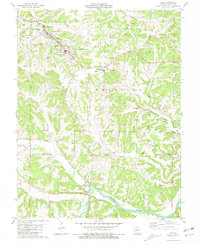
 1987 Argyle1988 Print · USGSThe borderlands of Osage and Maries counties are captured here in the late twentieth century, showing a landscape of winding creeks and small crossroads. Genealogists can trace family footprints near Argyle, Koeltztown, and the Cem along the banks of Loose Creek.
 - 1987 Map of Wardsville, 1988 Print
 1987 Wardsville1988 Print · USGSThe winding Osage River corridor comes into focus in the late 1980s, revealing a landscape of upland farms and riverbank forests. Trace family roots and local landmarks from Wardsville to Osage Bend, and explore the grounds of Painted Rock State Forest.
End of results
Showing maps 1-14 of 14
Top cities of Osage County
- Linn historical maps
- Chamois historical maps
- Freeburg historical maps
- Westphalia historical maps
- Meta historical maps
Frequently asked questions
- What are the different types of historical maps available for Osage County?
- What is the oldest map of Osage County?
- Where can I purchase historical maps of Osage County for my home or office?
- Where can I download high-res historical maps of Osage County?
- Are there historical topographic maps available for Osage County?
- Is there historical aerial imagery available for Osage County?
- Where are historical maps of Osage County sourced from?