1930s Maps of Pemiscot County, Missouri
Explore 3 historic maps of Pemiscot County from the 1930s. These maps offer a rare glimpse into what life looked like during the 1930s — showing old roads, neighborhoods, homes, and landmarks that have changed or disappeared over time.
Whether you're researching your family's past, planning a metal detecting trip, or studying how Pemiscot County's landscape evolved across the 1930s, these high-resolution maps are a powerful tool for exploring the history of this region.
- Focus on a specific era: All maps on this page are from the 1930s, giving you a focused view of this time period.
- See what’s changed: Compare century-old streets, trails, and buildings to today's modern landscape using overlays and satellite layers.
- Research with precision: Use these maps for genealogy, historical research, land use analysis, or educational projects.
- View, download, or print: Maps are fully viewable online in high resolution, and can be downloaded or printed for your own records.
Start exploring Pemiscot County's history through authentic maps from the 1930s. This is your window into the past.
Pemiscot County, MO maps
(3)- 1939 Map of Portageville, 1941 Print
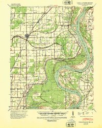 1939 Portageville1941 Print · USGSThe Missouri Bootheel meets the winding Mississippi River in the 1930s, showing a landscape defined by drainage bayous and new rail towns. Genealogists can locate family landmarks like Branham Cem and numerous rural schoolhouses including Walnut Grove Sch and Stanley Sch.2 unique versions available
 - 1939 Map of Caruthersville, 1943 Print
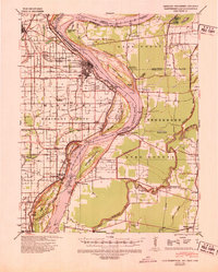 1939 Caruthersville1943 Print · USGSThe Missouri bootheel and Tennessee riverfront are documented here just before the Second World War, showing a landscape defined by the Mississippi's bends. Researchers can trace rural lineages through local landmarks like Mt Olive Ch & Sch, Mengelwood, and the many riverfront schools.2 unique versions available
 - 1939 Map of Blytheville, 1944 Print
 1939 Blytheville1944 Print · USGSMississippi County at the end of the Depression reveals a landscape of engineered drainage and thriving rail junctions. Genealogists and local historians can trace family locations near Blytheville, Cards Chapel & Cem, and the river landing at Ashport.
End of results
Showing maps 1-3 of 3
Top cities of Pemiscot County
- Caruthersville historical maps
- Hayti historical maps
- Steele historical maps
- Hayti Heights historical maps
- Cooter historical maps
- Wardell historical maps
See more
Frequently asked questions
- What are the different types of historical maps available for Pemiscot County?
- What is the oldest map of Pemiscot County?
- Where can I purchase historical maps of Pemiscot County for my home or office?
- Where can I download high-res historical maps of Pemiscot County?
- Are there historical topographic maps available for Pemiscot County?
- Is there historical aerial imagery available for Pemiscot County?
- Where are historical maps of Pemiscot County sourced from?