1940s Maps of Pemiscot County, Missouri
Explore 2 historic maps of Pemiscot County from the 1940s. These maps offer a rare glimpse into what life looked like during the 1940s — showing old roads, neighborhoods, homes, and landmarks that have changed or disappeared over time.
Whether you're researching your family's past, planning a metal detecting trip, or studying how Pemiscot County's landscape evolved across the 1940s, these high-resolution maps are a powerful tool for exploring the history of this region.
- Focus on a specific era: All maps on this page are from the 1940s, giving you a focused view of this time period.
- See what’s changed: Compare century-old streets, trails, and buildings to today's modern landscape using overlays and satellite layers.
- Research with precision: Use these maps for genealogy, historical research, land use analysis, or educational projects.
- View, download, or print: Maps are fully viewable online in high resolution, and can be downloaded or printed for your own records.
Start exploring Pemiscot County's history through authentic maps from the 1940s. This is your window into the past.
Pemiscot County, MO maps
(2)- 1940 Map of Pascola, 1942 Print
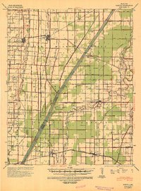 1940 Pascola1942 Print · USGSThe Missouri Bootheel is shown here during a period of massive land reclamation and rail-driven growth. Family historians can trace rural roots at Miller Sch, Mount Gilead Cem, and the timber-focused Lumber Yard in Gideon.
 - 1940 Map of Hayti, 1943 Print
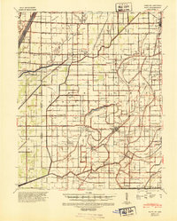 1940 Hayti1943 Print · USGSSoutheast Missouri’s fertile lowlands are captured here in the early 1940s, showing a landscape defined by drainage canals and rail-side commerce. Genealogists can trace family roots through numerous small schools and cemeteries, such as Cupp Cem and Gibson Sch.2 unique versions available
End of results
Showing maps 1-2 of 2
Top cities of Pemiscot County
- Caruthersville historical maps
- Hayti historical maps
- Steele historical maps
- Hayti Heights historical maps
- Cooter historical maps
- Wardell historical maps
See more
Frequently asked questions
- What are the different types of historical maps available for Pemiscot County?
- What is the oldest map of Pemiscot County?
- Where can I purchase historical maps of Pemiscot County for my home or office?
- Where can I download high-res historical maps of Pemiscot County?
- Are there historical topographic maps available for Pemiscot County?
- Is there historical aerial imagery available for Pemiscot County?
- Where are historical maps of Pemiscot County sourced from?