1930s Maps of Saint Charles County, Missouri
Explore 9 historic maps of Saint Charles County from the 1930s. These maps offer a rare glimpse into what life looked like during the 1930s — showing old roads, neighborhoods, homes, and landmarks that have changed or disappeared over time.
Whether you're researching your family's past, planning a metal detecting trip, or studying how Saint Charles County's landscape evolved across the 1930s, these high-resolution maps are a powerful tool for exploring the history of this region.
- Focus on a specific era: All maps on this page are from the 1930s, giving you a focused view of this time period.
- See what’s changed: Compare century-old streets, trails, and buildings to today's modern landscape using overlays and satellite layers.
- Research with precision: Use these maps for genealogy, historical research, land use analysis, or educational projects.
- View, download, or print: Maps are fully viewable online in high resolution, and can be downloaded or printed for your own records.
Start exploring Saint Charles County's history through authentic maps from the 1930s. This is your window into the past.
Saint Charles County, MO maps
(9)- 1931 Map of Brussels
 1931 Brussels1931 Print · USGSThe peninsula between the Illinois and Mississippi Rivers is captured here in the early 1930s, showcasing a network of river landings and ridge-top settlements. Genealogists can trace family roots through numerous local landmarks like Golden Eagle, Point Pleasant, and Nichols Sch.2 unique versions available
 - 1932 Map of Manchester NE
 1932 Manchester NE1932 Print · USGSThe Missouri River floodplain and the rising bluffs of St. Louis County are captured here in the early 1930s. Genealogists and local historians can trace the foundations of Chesterfield and Bellefontaine alongside sites like Zion Sch and the St Louis City Water Works.
 - 1933 Map of Creve Coeur
 1933 Creve Coeur1933 Print · USGSSt. Louis County in the early thirties shows a landscape of growing suburbs and deep-rooted cemeteries. Trace family history at Fee Fee Cemetery and locate old landmarks like Chaminade College or the Zion Sch.
 - 1933 Map of Saint Charles
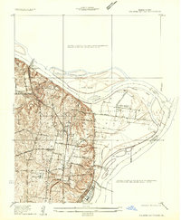
 1933 Saint Charles1933 Print · USGSThe confluence of the Missouri and Mississippi rivers in the early thirties reveals a landscape of fertile river bottoms and emerging suburban rail towns. Genealogists and researchers can trace old school districts like Cul de Sac Sch and historic sites such as St Stanislaus Seminary.3 unique versions available
 - 1934 Map of Alton
 1934 Alton1934 Print · USGSThe confluence of the Mississippi and Missouri rivers in the early 1930s shows a dense industrial and rail corridor centered on Alton. Genealogists and researchers can trace dozens of rural schools and landmarks like Monticello Seminary, Mt Olive Church, and the City of St Louis Farms.2 unique versions available
 - 1935 Map of Florissant
 1935 Florissant1935 Print · USGSSt. Louis County is captured during the mid-1930s as rural landscapes begin to integrate with early aviation and highway networks. Genealogists can trace family names at St Stanislaus Seminary, Halls Ferry, or the early Lambert St Louis Landing Field.
 - 1935 Map of Columbia Bottom
 1935 Columbia Bottom1935 Print · USGSSt. Louis County and the river confluence are captured here in the mid-1930s, showing a landscape of municipal farms and rural school districts. Genealogists can trace local roots through landmarks like Ruegg PO, Larimore, and the Vossenkemper School.
 - 1937 Map of Weldon Spring
 1937 Weldon Spring1937 Print · USGSThe Missouri River bottoms and the rising hills of St. Charles County are shown here in the late thirties, just as industrial and parkland developments began to reshape the region. Genealogists can locate several family burial grounds like Wolf Cem and Howell Cem, alongside rural centers such as Centaur Station and Toonerville.
 - 1939 Map of Brussels, 1955 Print
 1939 Brussels1955 Print · USGSThe confluence of the Illinois and Mississippi rivers defines this pre-war era, where river landings and ferries still anchored local life. Genealogists can trace family footprints at Old Rock Ch, numerous rural schools like Black Jack Sch, and the West Point Ferry.
End of results
Showing maps 1-9 of 9
Top cities of Saint Charles County
- O'Fallon historical maps
- Saint Charles historical maps
- Saint Peters historical maps
- Wentzville historical maps
- Harvester historical maps
- Dardenne Prairie historical maps
See more
Frequently asked questions
- What are the different types of historical maps available for Saint Charles County?
- What is the oldest map of Saint Charles County?
- Where can I purchase historical maps of Saint Charles County for my home or office?
- Where can I download high-res historical maps of Saint Charles County?
- Are there historical topographic maps available for Saint Charles County?
- Is there historical aerial imagery available for Saint Charles County?
- Where are historical maps of Saint Charles County sourced from?