2000-2009 Maps of Saint Francois County, Missouri
Explore 3 historic maps of Saint Francois County from 2000-2009. These maps offer a rare glimpse into what life looked like during the 2000s — showing old roads, neighborhoods, homes, and landmarks that have changed or disappeared over time.
Whether you're researching your family's past, planning a metal detecting trip, or studying how Saint Francois County's landscape evolved across the 2000s, these high-resolution maps are a powerful tool for exploring the history of this region.
- Focus on a specific era: All maps on this page are from the 2000s, giving you a focused view of this time period.
- See what’s changed: Compare century-old streets, trails, and buildings to today's modern landscape using overlays and satellite layers.
- Research with precision: Use these maps for genealogy, historical research, land use analysis, or educational projects.
- View, download, or print: Maps are fully viewable online in high resolution, and can be downloaded or printed for your own records.
Start exploring Saint Francois County's history through authentic maps from the 2000s. This is your window into the past.
Saint Francois County, MO maps
(3)- 2000 Map of Womack, 2003 Print
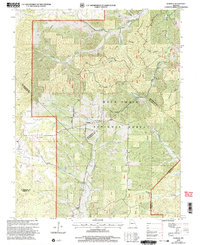 2000 Womack2003 Print · USGSSoutheast Missouri at the turn of the millennium reveals a rugged landscape where four counties meet within the national forest. Researchers can trace the river systems of the Castor River and Whitewater River or locate local landmarks like Silver Point Ch and McDowell Cem.
 - 2000 Map of Iron Mountain Lake, 2003 Print
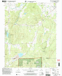 2000 Iron Mountain Lake2003 Print · USGSThe St. Francois Mountains area of Missouri is captured here just as the new millennium began, showing a landscape defined by mining history and timbered heights. Researchers can trace family roots through several rural burial sites like the German Cem and landmarks such as Stone Union Ch or the settlement of Doe Run.
 - 2000 Map of Parker Lake, 2003 Print
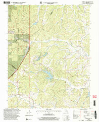 2000 Parker Lake2003 Print · USGSSoutheast Missouri at the turn of the millennium reveals a rugged network of forest lands and rural watercourses. Genealogists and local historians can locate several historic school sites, including Layton Sch and May Sch, alongside Parker Lake.
End of results
Showing maps 1-3 of 3
Top cities of Saint Francois County
- Farmington historical maps
- Park Hills historical maps
- Bonne Terre historical maps
- Desloge historical maps
- Bismarck historical maps
- Leadwood historical maps
See more
Frequently asked questions
- What are the different types of historical maps available for Saint Francois County?
- What is the oldest map of Saint Francois County?
- Where can I purchase historical maps of Saint Francois County for my home or office?
- Where can I download high-res historical maps of Saint Francois County?
- Are there historical topographic maps available for Saint Francois County?
- Is there historical aerial imagery available for Saint Francois County?
- Where are historical maps of Saint Francois County sourced from?