1950s Maps of Saint Francois County, Missouri
Explore 15 historic maps of Saint Francois County from the 1950s. These maps offer a rare glimpse into what life looked like during the 1950s — showing old roads, neighborhoods, homes, and landmarks that have changed or disappeared over time.
Whether you're researching your family's past, planning a metal detecting trip, or studying how Saint Francois County's landscape evolved across the 1950s, these high-resolution maps are a powerful tool for exploring the history of this region.
- Focus on a specific era: All maps on this page are from the 1950s, giving you a focused view of this time period.
- See what’s changed: Compare century-old streets, trails, and buildings to today's modern landscape using overlays and satellite layers.
- Research with precision: Use these maps for genealogy, historical research, land use analysis, or educational projects.
- View, download, or print: Maps are fully viewable online in high resolution, and can be downloaded or printed for your own records.
Start exploring Saint Francois County's history through authentic maps from the 1950s. This is your window into the past.
Saint Francois County, MO maps
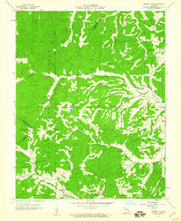
(15)- 1950 Map of Fredericktown
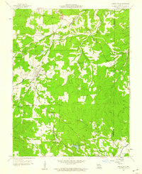
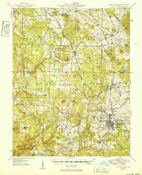 1950 Fredericktown1950 Print · USGSFredericktown and the surrounding mineral-rich hills are shown here just after the war, when mining and rail travel still anchored the local economy. Researchers can locate vanished rural schoolhouses like Brightstone Sch and trace the rail lines serving the Catherine Mines and Park City Mines.2 unique versions available
 - 1953 Map of Ironton
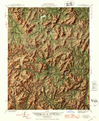 1953 Ironton1953 Print · USGSThe St. Francois Mountains of the Missouri Ozarks are captured here during the mid-century industrial era. Genealogists and historians can trace rail-side settlements like Arcadia and Ironton or find family landmarks such as Rebel Cem and White Sch.
 - 1953 Map of Rolla
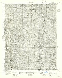
 1953 Rolla1953 Print · USGSSoutheast Missouri’s mining towns and timberlands are seen here at the start of the 1950s. Genealogists and historians can trace the rail-and-river economy through local hubs like Fredericktown and the lead-mining heritage of Potosi and Desloge.
 - 1954 Map of Rolla, 1970 Print
 1954 Rolla1970 Print · USGSThe Missouri Ozarks and the historic Lead Belt are captured in the late sixties, showing a landscape of deep river hollows and industrial mines. Researchers can trace the routes of the Missouri Pacific RR to extraction sites like the Iron Mountain Mine or Pea Ridge Mine.2 unique versions available
 - 1955 Map of De Soto SE
 1955 De Soto SE1955 Print · USGSJefferson and St. Francois counties in the early thirties reveal a landscape of ridge-top schools and river-valley railroads. Genealogists can trace family names at Joachim Cem or locate the old Tunnel Sta and Silver Springs Sta along the rail lines.
 - 1958 Map of Rolla
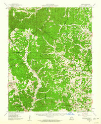
 1958 Rolla1958 Print · USGSThe Missouri Ozarks and the lead-rich hills of the southeast are captured here in the late fifties as timber and mining shaped the local economy. Researchers can locate family landmarks like the Rolla Cemetery or trace old rail lines including the Missouri-Illinois RR and St Louis-San Francisco RR.
 - 1958 Map of Irondale, 1959 Print
 1958 Irondale1959 Print · USGSIron County's mining and railroad heritage are on full display in the late 1950s near the Washington and St. Francois border. Researchers can trace the lineage of local families through Wallen Cem and locate historic operations like the Eversole Mine or Irondale Mine.3 unique versions available
 - 1958 Map of Mineral Point, 1959 Print
 1958 Mineral Point1959 Print · USGSWashington and St. Francois counties in the late fifties are defined by a landscape of industrial extraction and quiet rural crossroads. Researchers can trace family history at Accuilla Cole Cem, locate the Potosi Lookout Tower, or study the rail operations at Cadet and Mineral Point.3 unique versions available
 - 1958 Map of Flat River, 1959 Print
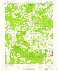
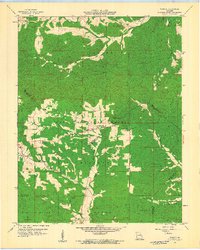
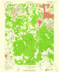 1958 Flat River1959 Print · USGSSt. Francois County is shown at the height of its industrial lead-mining era, characterized by massive tailings piles and a dense network of company towns. Researchers can trace ancestral roots through sites like St Johns Cem, the local Jr College, and the sprawling works at Rivermines and Leadwood.4 unique versions available
 - 1958 Map of Bonne Terre, 1959 Print
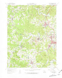 1958 Bonne Terre1959 Print · USGSThe Missouri Lead Belt is shown in full industrial detail during the late 1950s, centered on the mining hubs and rail lines of St. Francois County. Researchers can trace family roots through numerous rural sites like White Cem, Germania Sch, and the Fountain Farm Mine.2 unique versions available
 - 1958 Map of Bonne Terre, 1959 Print
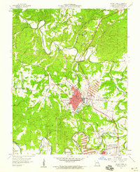 1958 Bonne Terre1959 Print · USGSMid-century St. Francois County reveals a complex mining landscape at the heart of the Lead Belt. Genealogists and local historians can trace family ties through Germania Cem and Settle Cem, or locate long-standing institutions like the Pleasant Mount Sch.4 unique versions available
 - 1959 Map of Rolla
 1959 Rolla1959 Print · USGSMid-century Missouri is defined here by the deep forests of the Ozarks and the industrial peaks of the St Francois Mountains. Genealogists and historians can trace the development of towns like Potosi and Fredericktown or locate rural landmarks like Dry Fork Church and the Phelps County Courthouse.
 - 1959 Map of Parker Lake, 1960 Print
 1959 Parker Lake1960 Print · USGSPerry County and the surrounding Ozark hills are captured here in the late fifties, showing a landscape of forest ridges and creek-bottom homesteads. Genealogists can trace family footprints near Baudendistel Sch, Whitewater Ch, and Parker Lake.3 unique versions available
 - 1959 Map of Higdon, 1960 Print
 1959 Higdon1960 Print · USGSThe rural borderlands of Madison, Perry, and Bollinger counties are captured here in the late fifties, defined by the winding Castor River and Whitewater River. Genealogists and historians can locate old mill sites like Hahns Mill, numerous country schools including Walnut Grove Sch, and family burial grounds like Underwood Cem.2 unique versions available
 - 1959 Map of Womack, 1960 Print
 1959 Womack1960 Print · USGSSoutheast Missouri’s forested hills and river headwaters are captured in the late fifties as rural life revolved around remote schoolhouses and forest lookouts. Researchers can trace family sites at McDowell Cem or locate community centers like Womack and Crossroads Sch.4 unique versions available
End of results
Showing maps 1-15 of 15
Top cities of Saint Francois County
- Farmington historical maps
- Park Hills historical maps
- Bonne Terre historical maps
- Desloge historical maps
- Bismarck historical maps
- Leadwood historical maps
See more
Frequently asked questions
- What are the different types of historical maps available for Saint Francois County?
- What is the oldest map of Saint Francois County?
- Where can I purchase historical maps of Saint Francois County for my home or office?
- Where can I download high-res historical maps of Saint Francois County?
- Are there historical topographic maps available for Saint Francois County?
- Is there historical aerial imagery available for Saint Francois County?
- Where are historical maps of Saint Francois County sourced from?