1900s (20th Century) Maps of Saline County, Missouri
Explore 42 historic maps of Saline County from the 1900s (20th Century). These maps offer a rare glimpse into what life looked like during the 1900s — showing old roads, neighborhoods, homes, and landmarks that have changed or disappeared over time.
Whether you're researching your family's past, planning a metal detecting trip, or studying how Saline County's landscape evolved across the 1900s, these high-resolution maps are a powerful tool for exploring the history of this region.
- Focus on a specific era: All maps on this page are from the 1900s, giving you a focused view of this time period.
- See what’s changed: Compare century-old streets, trails, and buildings to today's modern landscape using overlays and satellite layers.
- Research with precision: Use these maps for genealogy, historical research, land use analysis, or educational projects.
- View, download, or print: Maps are fully viewable online in high resolution, and can be downloaded or printed for your own records.
Start exploring Saline County's history through authentic maps from the 1900s. This is your window into the past.
Saline County, MO maps
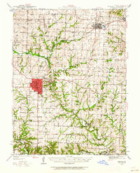
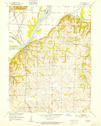
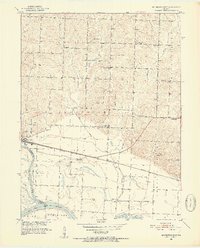
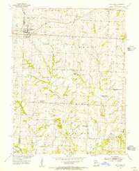
(42)- 1901 Map of Marshall
 1901 Marshall1901 Print · USGSCentral Missouri thrives along the river and rail lines at the turn of the century. Trace the early footprints of Marshall and Slater, or locate long-standing river landings and rural stations like Miami Station, Malta Bend, and Laynesville.5 unique versions available
 - 1939 Map of Sweet Springs
 1939 Sweet Springs1939 Print · USGSThe rural borderlands of Saline and Pettis Counties are captured here at the end of the 1930s as the rail and highway systems began to modernize the landscape. Genealogists can locate numerous country schoolhouses and churches like Sunny Dell Sch, Oak Grove Cem, and Houstonia.
 - 1940 Map of Sweet Springs
 1940 Sweet Springs1940 Print · USGSWestern Missouri in the late thirties is revealed here as a landscape of interconnected river valleys and tightly knit rural communities. Genealogists and historians can trace family roots through numerous country schools and landmarks like High Hill Cem, Bleak Mound, and the Missouri Pacific rail line.
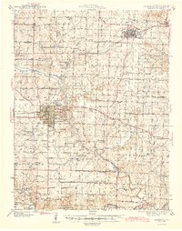
 - 1940 Map of Marshall, 1962 Print
 1940 Marshall1962 Print · USGSSaline County in the late Depression era shows a landscape of small crossroads communities and family-named schools. Genealogists can trace rural roots at Bucksnort Sch, Missouri Valley College, and family burial grounds like Sappington Cem.
 - 1941 Map of Sweet Springs
 1941 Sweet Springs1941 Print · USGSCentral Missouri farmland at the end of the Depression is defined here by the winding Blackwater River and the critical Missouri Pacific rail line. Genealogists and local historians can locate dozens of country schools and churches, such as Holy Cross Sch, Dunksburg, and the High Hill Cem.2 unique versions available
 - 1944 Map of Marshall
 1944 Marshall1944 Print · USGSSaline County centered on Marshall in the 1940s is a landscape of rural schools and intersecting rail lines. Genealogists can trace family roots through dozens of named sites like Sunset Hill Cem, Sulphur Springs Sch, and Blue Lick Springs.2 unique versions available
 - 1945 Map of Sweet Springs
 1945 Sweet Springs1945 Print · USGSCentral Missouri farmland at the end of the 1930s is revealed here, spanning the intersection of four counties. Genealogists can trace family roots through numerous rural landmarks like Holy Cross Ch, Weber Sch, and the isolated High Hill Cem.2 unique versions available
 - 1947 Map of Glasgow
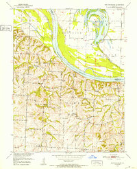
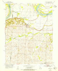
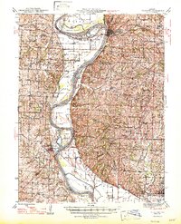 1947 Glasgow1947 Print · USGSThe Missouri River bottomlands in the mid-1940s reveal a landscape of shifting channels and established river towns. You can trace early settlement patterns through numerous rural landmarks like Sappington Cem, Boonesboro, and Farmers High Sch.2 unique versions available
 - 1947 Map of Jefferson City, 1949 Print
 1947 Jefferson City1949 Print · USGSCentral Missouri and the northern Ozarks come into focus in this late 1940s survey of the river-and-rail landscape. Genealogists and historians can trace the growth of Jefferson City and Sedalia or locate family roots near Bagnell Dam and the Lake of the Ozarks.
 - 1951 Map of Miami, 1952 Print
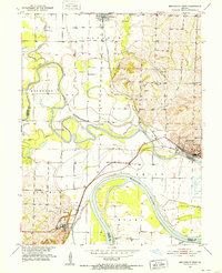
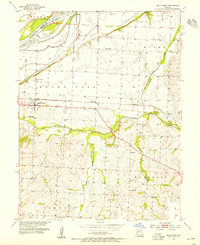
 1951 Miami1952 Print · USGSSaline and Carroll Counties meet along the Missouri River in the early fifties, showing a landscape of river-bottom rail lines and upland farming. Genealogists can trace family footprints at Burruss Sch, Harmony Ch, and the rural community of Sharon.2 unique versions available
 - 1951 Map of Brunswick West, 1952 Print
 1951 Brunswick West1952 Print · USGSThe river bottomlands of Chariton and Carroll Counties are captured here in the early 1950s, showing a landscape defined by the winding Missouri River. Genealogists and researchers can locate several rural schools such as Smith Sch and local burial sites like Allega Cem.4 unique versions available
 - 1951 Map of Miami Station, 1952 Print
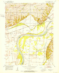 1951 Miami Station1952 Print · USGSCarroll and Saline counties sit divided by the winding Missouri River in the early fifties, showcasing a landscape of protected bottomlands and hilltop farmsteads. Researchers can trace rural life through family burial sites like Adkins Cem and vanished landmarks such as Miami Station and White Rock Sch.2 unique versions available
 - 1951 Map of Carrollton East, 1952 Print
 1951 Carrollton East1952 Print · USGSCarroll County at mid-century reveals a landscape defined by the winding Missouri River and a dense network of country schools. Researchers can trace the dual rail lines of the Wabash and Atchison Topeka and Santa Fe near Wakenda and Dietrich Sch.4 unique versions available
 - 1951 Map of Brunswick East, 1952 Print
 1951 Brunswick East1952 Print · USGSChariton County, Missouri, is captured in the early fifties as the riverfront economy and rural school system underwent significant shifts. Genealogists can trace family landmarks and defunct rural districts like Warden Sch and Prairie Chapel Cem along the Wabash line.3 unique versions available
 - 1951 Map of New Frankfort, 1952 Print
 1951 New Frankfort1952 Print · USGSThe Missouri River bluffs and bottomlands of Saline County appear here in the early fifties, documenting a landscape of rural schools and family cemeteries. Genealogists can trace the locations of New Frankfort Cem, High Hill Sch, and Prospect Ch.2 unique versions available
 - 1953 Map of Moberly
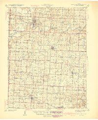
 1953 Moberly1953 Print · USGSMid-century north-central Missouri is documented here as a bustling intersection of river commerce and heavy rail. Researchers can trace historic family-named landmarks and transport hubs from the Missouri River corridor to the rail yards of Moberly, Chillicothe, and Macon.
 - 1953 Map of Nelson, 1955 Print
 1953 Nelson1955 Print · USGSMid-Missouri farming and river life are preserved here during the early fifties, where the Blackwater River and Lamine River meet. Researchers can locate vanished rural landmarks like Postal Sch, Millers Chapel, and the Raines Cemetery.2 unique versions available
 - 1953 Map of Longwood, 1955 Print
 1953 Longwood1955 Print · USGSThe borderlands of Saline and Pettis Counties come alive in the early 1950s, showing a landscape defined by the Blackwater River and rural township life. Genealogists and historians can locate family landmarks like Witcher Cem or trace the old roads near Marshall Junction and Longwood.2 unique versions available
 - 1953 Map of Blackburn, 1955 Print
 1953 Blackburn1955 Print · USGSThe Saline and Lafayette County line was a landscape of shifting rural education and rail-side commerce in the early 1950s. Genealogists can trace family names and community centers through sites like Blackburn Cem, Kennedy Sch, and the now-abandoned Carmean Sch.2 unique versions available
 - 1953 Map of Grand Pass, 1955 Print
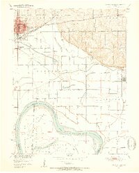
 1953 Grand Pass1955 Print · USGSMid-century Saline County comes into focus in this study of the river bluffs and bottomlands during the early fifties. Genealogists and local historians can locate the Mt Nebo Cem, trace the Missouri Pacific line, and find the Santa Fe Sch.2 unique versions available
 - 1953 Map of Shackleford, 1955 Print
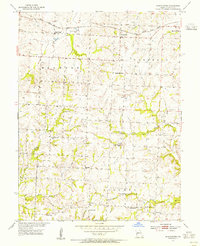 1953 Shackleford1955 Print · USGSSaline County’s agrarian heartland is shown in the early fifties, anchored by the rail stop at Shackleford and the rural crossroads of Herndon. Genealogists can trace family roots through numerous country schools and sites like Goshen Cem and Antioch Ch.2 unique versions available
 - 1953 Map of Malta Bend, 1955 Print
 1953 Malta Bend1955 Print · USGSMid-Missouri farming and rail life are centered on Malta Bend during the early fifties, where the Missouri Pacific connects small hubs like Stanhope. Genealogists can trace local roots through numerous landmarks including Lincoln Sch, Saline Ch, and Little Grove Cem.2 unique versions available
 - 1954 Map of Jefferson City
 1954 Jefferson City1954 Print · USGSCentral Missouri in the early postwar years showcases a landscape defined by the winding Lake of the Ozarks and the state capital at Jefferson City. Researchers can trace the mid-century rail networks of the Missouri Pacific RR and locate rural communities like Tuscumbia, St Elizabeth, and St Anthony.2 unique versions available
 - 1954 Map of Moberly, 1969 Print
 1954 Moberly1969 Print · USGSMid-century Missouri is captured here during a period of transition for its river towns and rail hubs. Genealogists and historians can trace the paths of the Wabash railroad through Moberly or explore the riverside layout of Lexington and Brunswick.3 unique versions available
 - 1955 Map of Jefferson City, 1967 Print
 1955 Jefferson City1967 Print · USGSCentral Missouri in the mid-fifties is defined by the winding Missouri River and the expanding reach of Lake of the Ozarks. Researchers can trace the rail corridors of the Missouri Pacific or locate the early footprint of Whiteman AFB and Jefferson City.4 unique versions available
Showing maps 1-25 of 42
Top cities of Saline County
- Marshall historical maps
- Slater historical maps
- Sweet Springs historical maps
- Malta Bend historical maps
- Gilliam historical maps
- Nelson historical maps
See more
Frequently asked questions
- What are the different types of historical maps available for Saline County?
- What is the oldest map of Saline County?
- Where can I purchase historical maps of Saline County for my home or office?
- Where can I download high-res historical maps of Saline County?
- Are there historical topographic maps available for Saline County?
- Is there historical aerial imagery available for Saline County?
- Where are historical maps of Saline County sourced from?