1960s Maps of Agency District, Montana
Explore 9 historic maps of Agency District from the 1960s. These maps offer a rare glimpse into what life looked like during the 1960s — showing old roads, neighborhoods, homes, and landmarks that have changed or disappeared over time.
Whether you're researching your family's past, planning a metal detecting trip, or studying how Agency District's landscape evolved across the 1960s, these high-resolution maps are a powerful tool for exploring the history of this region.
- Focus on a specific era: All maps on this page are from the 1960s, giving you a focused view of this time period.
- See what’s changed: Compare century-old streets, trails, and buildings to today's modern landscape using overlays and satellite layers.
- Research with precision: Use these maps for genealogy, historical research, land use analysis, or educational projects.
- View, download, or print: Maps are fully viewable online in high resolution, and can be downloaded or printed for your own records.
Start exploring Agency District's history through authentic maps from the 1960s. This is your window into the past.
Agency District, MT maps
(9)- 1964 Map of Threemile Reservoir, 1967 Print
 1964 Threemile Reservoir1967 Print · USGSNorth of the Milk River in the mid-sixties, this area of Blaine County shows the development of the Missouri River Basin. Genealogists and historians can trace the Fort Belknap Indian Reservation boundary and locate the Sacred Heart Ch near Threemile Reservoir.
 - 1964 Map of Coburg, 1967 Print
 1964 Coburg1967 Print · USGSThe rural plains of northern Montana are captured here in the 1960s, centered on the railroad siding of Coburg. Genealogists and historians can trace the Great Northern rail line and locate the Horn Cem near the banks of the Milk River.
 - 1964 Map of Fort Belknap Agency, 1967 Print
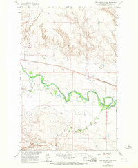
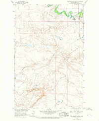 1964 Fort Belknap Agency1967 Print · USGSThe Fort Belknap Indian Reservation in the mid-sixties is centered on the Fort Belknap Agency along the winding Milk River. Researchers can trace the path of the Old Railroad Grade and locate landmarks like Snake Butte and the local Cem.
 - 1964 Map of Big Coulee, 1967 Print
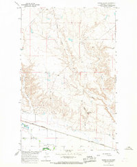
 1964 Big Coulee1967 Print · USGSBlaine County ranchlands and the western edge of the reservation appear in the mid-sixties as part of the Missouri River Basin project. Researchers can trace the Fort Belknap Indian Reservation Boundary and locate local landmarks like Snake Butte and the Snake Butte Sch.
 - 1964 Map of Grable Coulee, 1967 Print
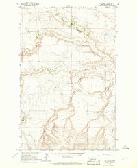
 1964 Grable Coulee1967 Print · USGSBlaine County's river valley and northern prairie are captured in the mid-1960s as irrigation and rail infrastructure shaped the plains. Researchers can trace the path of the Great Northern railroad and locate water sources like Thirtymile Reservoir and Grable Coulee Spring.
 - 1964 Map of Savoy, 1967 Print
 1964 Savoy1967 Print · USGSThe Milk River valley and the Fort Belknap Indian Reservation are shown in the mid-1960s, a period of managed irrigation and rail-side growth. Trace old property lines near Savoy, the Great Northern railroad, and the Fort Belknap Cem.
 - 1964 Map of Weigand Reservoir, 1967 Print
 1964 Weigand Reservoir1967 Print · USGSThe northern Montana prairie comes into focus during the 1960s, showing the intersection of the Fort Belknap Indian Reservation and the county line. Trace the local hydrology through landmarks like Weigand Reservoir, Old Woman Lake, and a rural Mine.
 - 1964 Map of Fort Belknap Siding, 1967 Print
 1964 Fort Belknap Siding1967 Print · USGSBlaine County ranching and rail transport are centered along the Milk River in the mid-1960s. Trace the irrigation network of the Fort Belknap Canal and the operations at Fort Belknap Siding on the Great Northern line.
 - 1964 Map of Harlem, 1967 Print
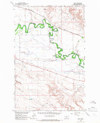
 1964 Harlem1967 Print · USGSThe northern Milk River valley comes into focus during the mid-sixties, showing the intersection of the Fort Belknap Indian Reservation and the town of Harlem. Researchers can trace the path of the Great Northern railway, find the town Cem, and locate the Rodeo Ground.
End of results
Showing maps 1-9 of 9
Top cities near Agency District
Top neighborhoods of Agency District
Frequently asked questions
- What are the different types of historical maps available for Agency District?
- What is the oldest map of Agency District?
- Where can I purchase historical maps of Agency District for my home or office?
- Where can I download high-res historical maps of Agency District?
- Are there historical topographic maps available for Agency District?
- Is there historical aerial imagery available for Agency District?
- Where are historical maps of Agency District sourced from?