1990s Maps of Carbon County, Montana
Explore 22 historic maps of Carbon County from the 1990s. These maps offer a rare glimpse into what life looked like during the 1990s — showing old roads, neighborhoods, homes, and landmarks that have changed or disappeared over time.
Whether you're researching your family's past, planning a metal detecting trip, or studying how Carbon County's landscape evolved across the 1990s, these high-resolution maps are a powerful tool for exploring the history of this region.
- Focus on a specific era: All maps on this page are from the 1990s, giving you a focused view of this time period.
- See what’s changed: Compare century-old streets, trails, and buildings to today's modern landscape using overlays and satellite layers.
- Research with precision: Use these maps for genealogy, historical research, land use analysis, or educational projects.
- View, download, or print: Maps are fully viewable online in high resolution, and can be downloaded or printed for your own records.
Start exploring Carbon County's history through authentic maps from the 1990s. This is your window into the past.
Carbon County, MT maps
(22)- 1991 Map of Castle Mountain, 1997 Print
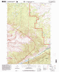
 1991 Castle Mountain1997 Print · USGSThe high alpine country of the Carbon County border is captured here during the 1990s as it spans three national forests. Researchers can trace the glaciated terrain of the Absaroka - Beartooth Wilderness through landmarks like Castle Rock Spire and Sundance Mountain.
 - 1991 Map of Fossil Lake, 1997 Print
 1991 Fossil Lake1997 Print · USGSThe high Beartooth Plateau along the Montana-Wyoming border is captured here in the early nineties, showing a landscape defined by glacial lakes and wilderness. Researchers can trace the alpine headwaters of the Broadwater River or locate remote landmarks like Mount Rosebud and Upper Aero Lake.
 - 1996 Map of Mackay Ranch, 1999 Print
 1996 Mackay Ranch1999 Print · USGSThe foothills of the Absaroka Range meet Carbon County ranchlands in the late twentieth century. Researchers can trace historic water rights and family land use through features like the Mackay Ranch, Roscoe Cem, and the Peabody Ditch.
 - 1996 Map of Red Lodge West, 1999 Print
 1996 Red Lodge West1999 Print · USGSThe Beartooth foothills come alive in the mid-nineties as the town of Red Lodge transitions into the high country of Custer National Forest. Researchers can trace the local development of the Red Lodge Mountain Ski Area, the historic Draper School, and the path of the Meeteetse Road.
 - 1996 Map of Mystery Cave, 1999 Print
 1996 Mystery Cave1999 Print · USGSThe Pryor Mountains during the mid-nineties show a landscape defined by wild horse management and national forest boundaries. Researchers can trace land use patterns through mines, prospects, and landmarks like Mystery Cave and Devil Canyon Overlook.
 - 1996 Map of Sylvan Peak, 1999 Print
 1996 Sylvan Peak1999 Print · USGSThe Absaroka Beartooth Wilderness and Custer National Forest are shown in high detail during the late twentieth century. Researchers can trace alpine terrain from Sylvan Peak to the waters of Calamity Falls and Timberline Lake.
 - 1996 Map of Big Ice Cave, 1999 Print
 1996 Big Ice Cave1999 Print · USGSThe high Montana plateaus of Carbon County are shown in detail during the late twentieth century, where forest land meets tribal territory. Researchers can trace remote homesteads like Greenough Ranch and locate distinctive landmarks such as Big Ice Cave and Harsten Flat.
 - 1996 Map of East Pryor Mountain, 1999 Print
 1996 East Pryor Mountain1999 Print · USGSThe Pryor Mountains in the mid-1990s show a landscape of tribal lands and national forests at the Big Horn County line. Researchers can locate remote landmarks like the Buffalo Jump, the Dry Head Ranch, and isolated Graves sites.
 - 1996 Map of Bear Canyon, 1999 Print
 1996 Bear Canyon1999 Print · USGSThe high country of the Pryor Mountains meets the Wyoming border in the mid-nineties. Trace remote water sources like Hard Luck Well and the rugged cuts of King Canyon and Bear Canyon.
 - 1996 Map of Emerald Lake, 1999 Print
 1996 Emerald Lake1999 Print · USGSStillwater and Carbon counties meet in this high-altitude Montana landscape during the late twentieth century, where forest management gives way to protected wilderness. You can trace early school sites and ranching outposts like Bedford School and Hash Ranch or locate remote high-mountain waters including Crater Lake and Emerald Lake.
 - 1996 Map of Roscoe, 1999 Print
 1996 Roscoe1999 Print · USGSThe Carbon County ranchlands near the Beartooth foothills are documented here in the late twentieth century. Family historians can trace local lineages through homesteads like the Joe Boggio Ranch, Rankin Place, and the Tony Cem burial ground.
 - 1996 Map of Indian Spring, 1999 Print
 1996 Indian Spring1999 Print · USGSThe northern slopes of the Pryor Mountains come alive in the late twentieth century at the boundary of the Crow Indian Reservation. Researchers can locate remote outposts like the Sage Creek Work Center, trace the rugged Graham Trail, and identify scattered mineral Prospects.
 - 1996 Map of Tolman Flat, 1999 Print
 1996 Tolman Flat1999 Print · USGSCrossing the Montana-Wyoming border in the late nineties, this area captures the transition from high-desert flats to national forest highlands. Researchers can trace the historic Meeteese Trail and locate the Grove Creek Mine set against the Tolman Flat landscape.
 - 1996 Map of Red Lodge East, 1999 Print
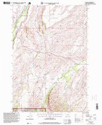
 1996 Red Lodge East1999 Print · USGSCarbon County's coal mining and ranching roots are well-preserved here in the mid-1990s as the high benches drop into the coulees east of Red Lodge. Genealogists and historians can trace the legacy of industrial sites like Smith Mine and local landmarks such as Clear Creek School.
 - 1996 Map of Red Pryor Mountain, 1999 Print
 1996 Red Pryor Mountain1999 Print · USGSThe high canyons and plateaus of Carbon County are shown in the late twentieth century as a mosaic of mining claims and protected ranges. Researchers can trace land use through local landmarks like Tillett Ranch and several named mines, including the Old Glory Mine and Swamp Frog Mine.
 - 1996 Map of Bowler, 1999 Print
 1996 Bowler1999 Print · USGSThe Montana-Wyoming border country comes alive in this late-nineties survey of the high plains and mountain breaks. Researchers can trace the quiet history of the region through the Bowler Cem, find old prospects near Black Butte, and follow the Bent Trail into the depths of Timber Canyon.
 - 1996 Map of Black Pyramid Mountain, 1999 Print
 1996 Black Pyramid Mountain1999 Print · USGSThe high Beartooth range along the Montana and Wyoming border comes into focus in the mid-nineties. Researchers can locate alpine mining sites like the Open Pit Mines and Prospect alongside landmarks such as Black Pyramid Mountain and Greenough Lake.
 - 1996 Map of Granite Peak, 1999 Print
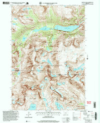 1996 Granite Peak1999 Print · USGSHigh in the Beartooth Range during the late twentieth century, this survey tracks the permanent ice and alpine waters of Montana's highest point. Researchers can locate remote features like the Montana Power Dam, Sky Top Glacier, and the aptly named Froze to Death Mountain.2 unique versions available
 - 1996 Map of Alpine, 1999 Print
 1996 Alpine1999 Print · USGSThe Beartooth Wilderness in the mid-1990s was a landscape of high-altitude glacial lakes and isolated settlements. Researchers can trace the drainages of West Rosebud Lake and East Rosebud Lake while locating the remote Phantom Glacier and Alpine trailhead.
 - 1996 Map of Silver Run Peak, 1999 Print
 1996 Silver Run Peak1999 Print · USGSHigh-altitude plateaus and glacial lakes define this Montana and Wyoming border region as it was surveyed in the mid-nineties. Researchers can trace the wild forest boundaries near Silver Run Peak and locate remote water bodies like Jasper Lake and Sundance Lake.
 - 1996 Map of Mount Maurice, 1999 Print
 1996 Mount Maurice1999 Print · USGSThe Montana-Wyoming borderlands appear at the end of the twentieth century as a high-wilderness landscape where two national forests meet. Genealogists and historians can trace the paths near Piney Dell or explore the rugged heights of Mount Maurice and the Westminster Spires.
 - 1996 Map of Bare Mountain, 1999 Print
 1996 Bare Mountain1999 Print · USGSThe high Montana backcountry of the mid-1990s is captured here, showing the dramatic rise from the West Fork Rock Creek to the high Silver Run Plateau. Hikers and local historians can trace the paths to Camp Senia, Lake Gertrude, and the Silver Run Ski Touring National Recreation Trail.
End of results
Showing maps 1-22 of 22
Top cities of Carbon County
- Red Lodge historical maps
- Bridger historical maps
- Joliet historical maps
- Fromberg historical maps
- Bearcreek historical maps
Frequently asked questions
- What are the different types of historical maps available for Carbon County?
- What is the oldest map of Carbon County?
- Where can I purchase historical maps of Carbon County for my home or office?
- Where can I download high-res historical maps of Carbon County?
- Are there historical topographic maps available for Carbon County?
- Is there historical aerial imagery available for Carbon County?
- Where are historical maps of Carbon County sourced from?