1980s Maps of Carbon County, Montana
Explore 16 historic maps of Carbon County from the 1980s. These maps offer a rare glimpse into what life looked like during the 1980s — showing old roads, neighborhoods, homes, and landmarks that have changed or disappeared over time.
Whether you're researching your family's past, planning a metal detecting trip, or studying how Carbon County's landscape evolved across the 1980s, these high-resolution maps are a powerful tool for exploring the history of this region.
- Focus on a specific era: All maps on this page are from the 1980s, giving you a focused view of this time period.
- See what’s changed: Compare century-old streets, trails, and buildings to today's modern landscape using overlays and satellite layers.
- Research with precision: Use these maps for genealogy, historical research, land use analysis, or educational projects.
- View, download, or print: Maps are fully viewable online in high resolution, and can be downloaded or printed for your own records.
Start exploring Carbon County's history through authentic maps from the 1980s. This is your window into the past.
Carbon County, MT maps
(16)- 1980 Map of Cody, 1982 Print
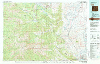 1980 Cody1982 Print · USGSThe Cody region in the early 1980s reveals a rugged wilderness of the Shoshone National Forest meeting the plains. Researchers can trace the Burlington Northern rail line and locate landmarks like Painter Mine and Buffalo Bill Reservoir.3 unique versions available
 - 1980 Map of Powell, 1982 Print
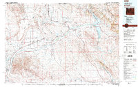 1980 Powell1982 Print · USGSThe Bighorn Basin in the 1980s shows a landscape where irrigation and rail transformed the high desert near the Montana border. Researchers can trace the path of the Burlington Northern line through historic stops like Garland, Frannie, and Deaver.
 - 1986 Map of Granite Peak
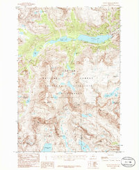 1986 Granite Peak1986 Print · USGSThe high Beartooth range in the mid-1980s is captured here in a period of pristine wilderness and glacial study. Researchers can trace the rugged topography of Granite Peak and the surrounding ice fields like Granite Glacier and Hidden Glacier.2 unique versions available
 - 1986 Map of Sylvan Peak
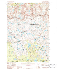
 1986 Sylvan Peak1986 Print · USGSCarbon County high country in the mid-1980s is defined by the high tablelands and glacial basins of the Absaroka-Beartooth Wilderness. Hikers and researchers can trace the Pack Trail past Sylvan Lake to remote landmarks like Calamity Falls and Quinnebaugh Meadows.
 - 1986 Map of Castle Mountain
 1986 Castle Mountain1986 Print · USGSThe high Beartooth range along the Montana and Wyoming border is shown here in the mid-1980s, just as these wilderness boundaries were being established. Hikers and explorers can trace remote routes like the Sierra Trail and Impasse Trail past landmarks like Sundance Glacier and Charlie Falls.2 unique versions available
 - 1986 Map of Bare Mountain
 1986 Bare Mountain1986 Print · USGSThe Beartooth Range high country is captured in this mid-1980s survey during a period of expanding federal wilderness protection. Researchers can trace remote alpine trails and high-basin water sources such as Lake Gertrude, Silver Run Lakes, and the grounds at Camp Senia.
 - 1986 Map of Alpine
 1986 Alpine1986 Print · USGSThe Beartooth Mountains are captured here in the mid-1980s, revealing a landscape of high-altitude lakes and pack trails. Study the trail access to Alpine or trace the drainage from Phantom Glacier past Froze-to-Death Lake and Rainbow Lake.
 - 1986 Map of Black Pyramid Mountain
 1986 Black Pyramid Mountain1986 Print · USGSThe high Beartooth Mountains near the Montana-Wyoming line are shown in the mid-eighties as a landscape of alpine plateaus and remote mineral exploration. Researchers can trace historic access via Pack Trail routes leading to Open Pit Mines and the shores of Snowbank Lake.2 unique versions available
 - 1986 Map of Mount Maurice
 1986 Mount Maurice1986 Print · USGSThe Beartooth foothills in the 1980s come into focus on this study of the Montana-Wyoming borderlands. Researchers can trace high-country landmarks like Mount Maurice and Wapiti Mtn, or locate the isolated settlement at Piney Dell and the trails near Rock Roadside Park.
 - 1986 Map of Silver Run Peak
 1986 Silver Run Peak1986 Print · USGSThe Montana-Wyoming border region is documented here in the mid-1980s, showcasing the high-elevation wilderness of the Beartooth Range. Hikers and researchers can trace the intricate networks of glacial basins and peaks like Silver Run Peak, Bears Tooth, and Albino Lake.
 - 1986 Map of Fossil Lake
 1986 Fossil Lake1986 Print · USGSThe high mountain reaches of the Montana-Wyoming border appear in this 1980s survey, documenting the point where three National Forests meet. Trace high-altitude landmarks like Fossil Lake, Mount Rosebud, and the winding Pack Trail through the Absaroka-Beartooth Wilderness.2 unique versions available
 - 1986 Map of Red Lodge West
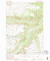
 1986 Red Lodge West1986 Print · USGSThe foothills of Carbon County meet the high peaks during the mid-eighties as the town of Red Lodge transitions into the wilderness. Trace local landmarks like the Cemetery, Rodeo Ground, and the dramatic Limestone Palisades above the creek forks.
 - 1987 Map of Badger Basin
 1987 Badger Basin1987 Print · USGSPark County, Wyoming, near the Montana line, is shown in the late 1980s as a hub of river-valley irrigation and industrial activity. Researchers can trace the water-management systems of the Clarks Fork Yellowstone River, including the Sirrine DITCH and several Aqueduct segments.
 - 1989 Map of Bridger
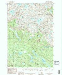
 1989 Bridger1989 Print · USGSThe river valleys and mountain ranges of south-central Montana come alive in the late eighties as the region balanced ranching and reservation life. Researchers can trace the Burlington Northern line through Bridger or locate Pryor within the Crow Indian Reservation.
 - 1989 Map of Billings
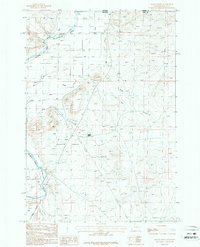
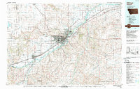 1989 Billings1989 Print · USGSThe Billings area in the late eighties shows a major regional hub at the height of its rail and river influence. Genealogists and historians can trace the development of outlying towns like Worden and Park City or the boundaries of the Crow Indian Reservation.
 - 1989 Map of Red Lodge
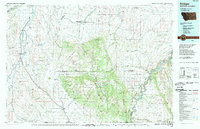
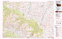 1989 Red Lodge1989 Print · USGSThe Beartooth Mountains and the Montana-Wyoming border come alive in this late 1980s map of the high plateau country. Genealogists and historians can trace the mining history of Bearcreek through the Brophy Mine and Foster Mine or locate the rural Church Hill.
End of results
Showing maps 1-16 of 16
Top cities of Carbon County
- Red Lodge historical maps
- Bridger historical maps
- Joliet historical maps
- Fromberg historical maps
- Bearcreek historical maps
Frequently asked questions
- What are the different types of historical maps available for Carbon County?
- What is the oldest map of Carbon County?
- Where can I purchase historical maps of Carbon County for my home or office?
- Where can I download high-res historical maps of Carbon County?
- Are there historical topographic maps available for Carbon County?
- Is there historical aerial imagery available for Carbon County?
- Where are historical maps of Carbon County sourced from?