1990s Maps of Cascade County, Montana
Explore 17 historic maps of Cascade County from the 1990s. These maps offer a rare glimpse into what life looked like during the 1990s — showing old roads, neighborhoods, homes, and landmarks that have changed or disappeared over time.
Whether you're researching your family's past, planning a metal detecting trip, or studying how Cascade County's landscape evolved across the 1990s, these high-resolution maps are a powerful tool for exploring the history of this region.
- Focus on a specific era: All maps on this page are from the 1990s, giving you a focused view of this time period.
- See what’s changed: Compare century-old streets, trails, and buildings to today's modern landscape using overlays and satellite layers.
- Research with precision: Use these maps for genealogy, historical research, land use analysis, or educational projects.
- View, download, or print: Maps are fully viewable online in high resolution, and can be downloaded or printed for your own records.
Start exploring Cascade County's history through authentic maps from the 1990s. This is your window into the past.
Cascade County, MT maps
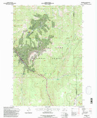
(17)- 1993 Map of Dearborn River
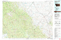 1993 Dearborn River1993 Print · USGSThe Montana wilderness and the Front Range come alive in this early 1990s overview of the high country near Augusta. Outdoor historians and researchers can trace the Continental Divide Trail or locate remote sites like Copper Camp and Milford Colony.
 - 1995 Map of Highwood Baldy
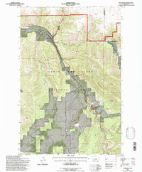
 1995 Highwood Baldy1995 Print · USGSThe Highwood Mountains in the mid-1990s offer a detailed view of the rugged terrain where Cascade, Chouteau, and Judith Basin counties meet. Researchers can trace the legacy of rural communities through sites like the Big Willow Cemetery, Mountain View Sch, and the Highwood Creek Community Hall.2 unique versions available
 - 1995 Map of Raynesford, 1997 Print
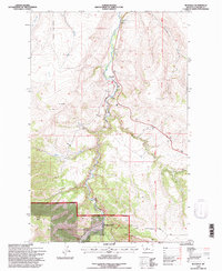
 1995 Raynesford1997 Print · USGSRaynesford sits at a critical junction of rail and river in the mid-1990s, nestled between the coulees and the Highwood peaks. Researchers can trace the Burlington Northern line through the valley or locate local landmarks like the Golladay site and Kibbey Canyon.
 - 1995 Map of Kings Hill, 1997 Print
 1995 Kings Hill1997 Print · USGSKings Hill Pass and the surrounding National Forest are captured here in the mid-nineties as a winter recreation destination. Researchers can trace the high-altitude trails around Porphyry Peak Lookout or locate the settlement of Forest Green near Sheep Creek.2 unique versions available
 - 1995 Map of Riceville, 1997 Print
 1995 Riceville1997 Print · USGSIn the Little Belt Mountains during the mid-nineties, this area shows a landscape shaped by forest management and the path of Belt Creek. Trace the path of the Old Railroad Grade near Riceville or locate Camp Don Bosco along the canyon floor.
 - 1995 Map of Neihart, 1997 Print
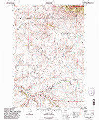
 1995 Neihart1997 Print · USGSNeihart and the Little Belt Mountains are captured here in the mid-1990s, showcasing a landscape shaped by high-altitude mining. Genealogists and historians can locate numerous claims like the Silver Dyke Mine and Broadwater Mines near Neihart.
 - 1995 Map of Evans, 1997 Print
 1995 Evans1997 Print · USGSThe area surrounding Evans in the mid-1990s showcases a transition from open Montana coulees to the high timber of the Lewis and Clark National Forest. Researchers can trace old drainage routes like Sand Coulee Creek and locate local landmarks such as Tiger Butte and scattered Gravel Pits.
 - 1995 Map of Belt Park Butte, 1997 Print
 1995 Belt Park Butte1997 Print · USGSHigh in the Little Belts during the mid-nineties, this survey captures the mining and forest history of the Neihart area. Trace early land use through family-named landmarks like Johannesburg, Neihart Cem, and Rocking Chair Park.
 - 1995 Map of Millegan, 1997 Print
 1995 Millegan1997 Print · USGSThe Smith River canyon country in the mid-1990s reveals a rugged landscape where the Lewis and Clark National Forest meets private ranch lands. Researchers can trace the remote settlement at Millegan, locate the Dick Anderson Cabin, and follow primitive 4WD trails across Millegan Hill.
 - 1995 Map of Deep Creek Park, 1997 Print
 1995 Deep Creek Park1997 Print · USGSThe Little Belt Mountains of Central Montana are shown here in the mid-1990s during a period of active Forest Service management. Researchers can trace land use via noted prospects and local landmarks like Simmons Park, Kings Hill Butte, and the Figure 8 Loop.
 - 1995 Map of Moose Mountain, 1997 Print
 1995 Moose Mountain1997 Print · USGSThe high Little Belt Mountains of Meagher County are captured here in the mid-1990s, dominated by the Lewis and Clark National Forest. Trace family-named landmarks and infrastructure like Kings Hill, Holstrom Ditch, and Jumping Creek.
 - 1995 Map of Barker, 1997 Print
 1995 Barker1997 Print · USGSThe Little Belt Mountains during the mid-1990s reveal a landscape defined by mining history and forest management. Researchers can locate the mountain settlements of Hughesville and Barker, alongside the Barker Cem and various Mine sites.
 - 1995 Map of Bubbling Springs, 1997 Print
 1995 Bubbling Springs1997 Print · USGSThe high meadows and research lands of the Lewis and Clark National Forest are shown here in the mid-1990s. Researchers can locate mineral Prospects, the Tenderfoot Creek Experimental Forest, and named meadows like Iron Mines Park.
 - 1995 Map of Thunder Mountain, 1997 Print
 1995 Thunder Mountain1997 Print · USGSThe high peaks of the Little Belt Mountains are captured here during the mid-nineties, showing the rugged management area of the Kings Hill Ranger District. Researchers can trace old mining interest through numerous prospects and follow backcountry routes like the Circle Trail.
 - 1995 Map of Monarch, 1997 Print
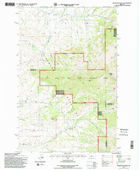
 1995 Monarch1997 Print · USGSMonarch and the surrounding Little Belt Mountains are shown during the mid-1990s as the area balanced its industrial past with forest recreation. Trace the path of the Old Railroad Grade along Belt Creek and locate local landmarks like Saint Thomas Camp or Keegan Peak.2 unique versions available
 - 1995 Map of Blankenbaker Flats, 1997 Print
 1995 Blankenbaker Flats1997 Print · USGSThe Little Belt Mountains of Cascade and Meagher counties are shown in the mid-1990s, dominated by the high terrain of the Lewis and Clark National Forest. Researchers can trace the rugged drainages of Logging Creek and Deep Creek or locate the namesake Blankenbaker Flats.
 - 1995 Map of Monarch NE, 1997 Print
 1995 Monarch NE1997 Print · USGSThe high Montana interior near the Cascade and Judith Basin county line comes into focus in the mid-1990s. Researchers can trace historic survey markers like GLO Post 26 and named drainages such as Monarch Canyon and Ford Coulee.
End of results
Showing maps 1-17 of 17
Top cities of Cascade County
- Great Falls historical maps
- Cascade historical maps
- Belt historical maps
- Stockett historical maps
- Neihart historical maps
Frequently asked questions
- What are the different types of historical maps available for Cascade County?
- What is the oldest map of Cascade County?
- Where can I purchase historical maps of Cascade County for my home or office?
- Where can I download high-res historical maps of Cascade County?
- Are there historical topographic maps available for Cascade County?
- Is there historical aerial imagery available for Cascade County?
- Where are historical maps of Cascade County sourced from?