1970s Maps of Cascade County, Montana
Explore 17 historic maps of Cascade County from the 1970s. These maps offer a rare glimpse into what life looked like during the 1970s — showing old roads, neighborhoods, homes, and landmarks that have changed or disappeared over time.
Whether you're researching your family's past, planning a metal detecting trip, or studying how Cascade County's landscape evolved across the 1970s, these high-resolution maps are a powerful tool for exploring the history of this region.
- Focus on a specific era: All maps on this page are from the 1970s, giving you a focused view of this time period.
- See what’s changed: Compare century-old streets, trails, and buildings to today's modern landscape using overlays and satellite layers.
- Research with precision: Use these maps for genealogy, historical research, land use analysis, or educational projects.
- View, download, or print: Maps are fully viewable online in high resolution, and can be downloaded or printed for your own records.
Start exploring Cascade County's history through authentic maps from the 1970s. This is your window into the past.
Cascade County, MT maps
(17)- 1971 Map of Boston Coulee School, 1974 Print
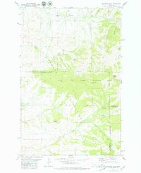
 1971 Boston Coulee School1974 Print · USGSThe Smith River canyon dominates this Cascade County landscape in the early seventies, where the Boston Coulee School served a remote ranching community. Researchers can trace land features like Chicken Coulee, Murphy Coulee, and an old mineral Prospect.
 - 1971 Map of Deep Creek Park, 1974 Print
 1971 Deep Creek Park1974 Print · USGSThe high Divide country of Montana is captured here in the early seventies, spanning the border of Cascade and Meagher Counties. Local historians and hikers can trace primitive routes to Simmons Park, Desolation Peak, and the waters of Temple Gulch.
 - 1971 Map of Spanish Coulee School, 1975 Print
 1971 Spanish Coulee School1975 Print · USGSThe Cascade County foothills in the early seventies reveal a landscape of deep coulees and river bends. Researchers can trace the ranching life around the Spanish Coulee Sch and find small industrial markers like the Mine or the Gaging Sta along the Smith River.
 - 1971 Map of Calvert, 1975 Print
 1971 Calvert1975 Print · USGSCascade County ranching country is captured here in the early seventies, showing a landscape defined by deep coulees and seasonal springs. Researchers can trace the rural infrastructure around Calvert, including the Calvert Sch and landmarks like Black Butte.
 - 1971 Map of Conway Ridge, 1975 Print
 1971 Conway Ridge1975 Print · USGSThe high range of the Montana-Meagher county line comes into focus in the 1970s, showing a landscape defined by water and altitude. Researchers can trace the drainages of Hound Creek and Coal Creek or locate landmarks like Streeter Hill and Mowing Machine Coulee.
 - 1971 Map of Millegan, 1975 Print
 1971 Millegan1975 Print · USGSThe ranching landscape of Cascade County is captured here in the early 1970s, focused on the winding river canyons and high prairies. Trace old access routes along the Smith River and the small settlement at Millegan or explore family landmarks like Simmons Park.
 - 1971 Map of Evans, 1975 Print
 1971 Evans1975 Print · USGSThe settlement of Evans and the northern fringe of the National Forest are captured here in the early 1970s. Trace the rural landscape through family-named drainages and terrain features like Tiger Butte, Half Breed Creek, and Bayes Coulee.
 - 1971 Map of Blankenbaker Flats, 1975 Print
 1971 Blankenbaker Flats1975 Print · USGSThe high country of the Little Belt Mountains is captured here in the early 1970s, spanning the Cascade and Meagher county line. Researchers can trace old mountain routes like the Pack Trail and locate isolated Prospects near Monument Ridge.
 - 1975 Map of Belt SE
 1975 Belt SE1975 Print · USGSCascade County ranching country is captured in the mid-seventies, showing the intricate landscape of the high plains before modern expansion. Local researchers can trace the settlement at Blythe and the winding drainages of Otter Creek and Cora Creek.
 - 1975 Map of Belt NW
 1975 Belt NW1975 Print · USGSCascade County in the mid-1970s reveals a high-contrast landscape of strip-cropping and river-valley industry. Trace the historic town limits of Belt along the banks of Belt Creek and locate the prominent landmark of Belt Butte.
 - 1975 Map of Belt NE
 1975 Belt NE1975 Print · USGSCentral Montana ranching country is captured during the mid-1970s in this detailed aerial study of the foothills northeast of Belt. Genealogists and land historians can trace the paths of Big Willow Creek and North Willow Creek to identify historical property lines and traditional grazing lands.
 - 1975 Map of Belt SW
 1975 Belt SW1975 Print · USGSCentral Montana ranching and river geography are captured in this mid-seventies aerial study of the plateau above the Highwood Mountains. Genealogists and researchers can trace the agricultural landscape surrounding Armington and the deep valleys of Belt Creek and Neel Creek.
 - 1975 Map of Canyon Ferry Dam, 1994 Print
 1975 Canyon Ferry Dam1994 Print · USGSThe Missouri River and Big Belt Mountains define this Montana landscape during the mid-seventies. Genealogists and historians can trace old mining sites like the Snowback Mine and industrial settlements including White City and Louisville.
 - 1976 Map of Choteau
 1976 Choteau1976 Print · USGSThe Montana Rocky Mountain Front meets the plains in the 1970s, showcasing the high-altitude wilderness and the irrigation-fed ranching country. Trace the Great Northern Railway through Choteau or locate rural landmarks like the Farmington Cemetery and Gibson Reservoir.
 - 1976 Map of Great Falls North, 1990 Print
 1976 Great Falls North1990 Print · USGSNorth of the Missouri River in the mid-seventies, this survey shows a region defined by extensive irrigation projects and the growing footprint of Great Falls. Researchers can trace the Burlington Northern rail lines through Dutton or locate the sprawling Benton Lake National Wildlife Refuge.
 - 1976 Map of Great Falls South, 1994 Print
 1976 Great Falls South1994 Print · USGSCascade County in the mid-seventies reveals a landscape defined by the winding Missouri River and the high peaks of the Little Belt Mountains. Researchers can trace the heritage of mining settlements like Centerville, Stockett, and Number Seven or explore the boundaries of the Lewis and Clark National Forest.
 - 1979 Map of Highwood Baldy
 1979 Highwood Baldy1979 Print · USGSThe Highwood Mountains in the late seventies remain a landscape of remote ranching outposts and high-country forests. Genealogists and local historians can locate the Big Willow Cemetery, Mountain View Sch, and the Highwood Creek Community Hall.2 unique versions available
End of results
Showing maps 1-17 of 17
Top cities of Cascade County
- Great Falls historical maps
- Cascade historical maps
- Belt historical maps
- Stockett historical maps
- Neihart historical maps
Frequently asked questions
- What are the different types of historical maps available for Cascade County?
- What is the oldest map of Cascade County?
- Where can I purchase historical maps of Cascade County for my home or office?
- Where can I download high-res historical maps of Cascade County?
- Are there historical topographic maps available for Cascade County?
- Is there historical aerial imagery available for Cascade County?
- Where are historical maps of Cascade County sourced from?