1970s Maps of Custer County, Montana
Explore 26 historic maps of Custer County from the 1970s. These maps offer a rare glimpse into what life looked like during the 1970s — showing old roads, neighborhoods, homes, and landmarks that have changed or disappeared over time.
Whether you're researching your family's past, planning a metal detecting trip, or studying how Custer County's landscape evolved across the 1970s, these high-resolution maps are a powerful tool for exploring the history of this region.
- Focus on a specific era: All maps on this page are from the 1970s, giving you a focused view of this time period.
- See what’s changed: Compare century-old streets, trails, and buildings to today's modern landscape using overlays and satellite layers.
- Research with precision: Use these maps for genealogy, historical research, land use analysis, or educational projects.
- View, download, or print: Maps are fully viewable online in high resolution, and can be downloaded or printed for your own records.
Start exploring Custer County's history through authentic maps from the 1970s. This is your window into the past.
Custer County, MT maps
(26)- 1971 Map of Brandenberg NW, 1974 Print
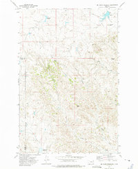
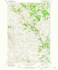
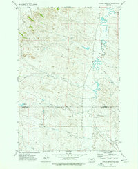
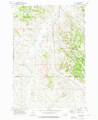
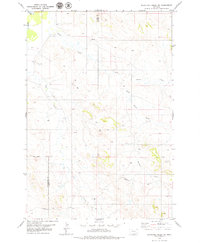
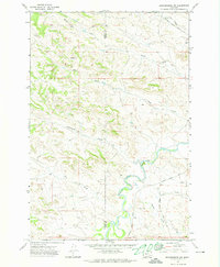 1971 Brandenberg NW1974 Print · USGSCuster County ranching country and the meandering river valley are captured here in the early 1970s. Researchers can trace land use through features like the Tongue River, various scattered wells, and remote routes such as Moon Creek Road.
 - 1971 Map of Hayes Point, 1974 Print
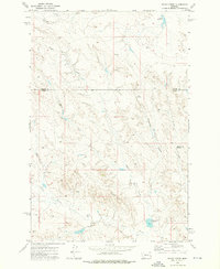
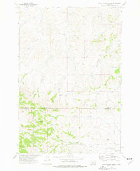
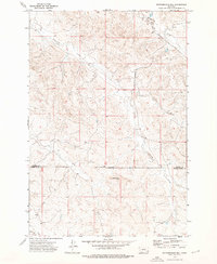
 1971 Hayes Point1974 Print · USGSSoutheastern Montana ranching country is documented here in the early seventies as the county line meets the national forest boundary. Researchers can trace historic access routes like Liscom Road and Beaver Creek Road past landmarks such as Hayes Point and Mullins Coulee.2 unique versions available
 - 1971 Map of HS School, 1974 Print
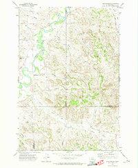
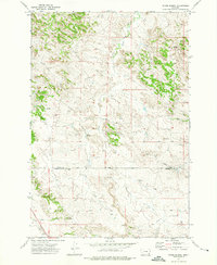
 1971 HS School1974 Print · USGSThe Tongue River valley in eastern Montana is captured here during the early 1970s, showing a remote landscape of ranches and coulees. Researchers can locate the H S School and trace the paths of Cow Creek and Garden Creek through the river breaks.
 - 1971 Map of Brandenberg, 1974 Print
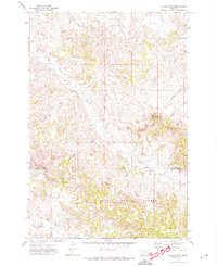
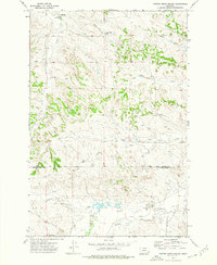
 1971 Brandenberg1974 Print · USGSThe Tongue River valley meets the rugged breaks of Custer County in the early 1970s. Trace local landmarks like Brandenberg, find the isolated Grave near Goodale Creek, and follow the winding path of Beaver Creek Road.
 - 1972 Map of Mc Clure Reservoir, 1975 Print
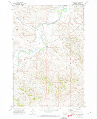
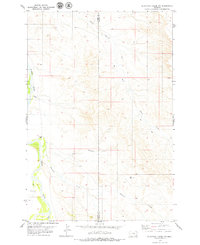
 1972 Mc Clure Reservoir1975 Print · USGSHigh plains ranching country along the Prairie and Custer County line is documented here in the early seventies. Researchers can trace remote water sources and cattle trails like Bootlegger Spring, Mc Clure Reservoir, and the Calypso Trail.
 - 1972 Map of Physic Creek, 1976 Print
 1972 Physic Creek1976 Print · USGSThe borderlands of Prairie and Custer counties come into focus in the early 1970s, showing a landscape shaped by ranching and water management. Researchers can locate remote land improvements and water sources like Swede Dam, Ingersol Buttes, and the Physic Creek Reservoir.
 - 1973 Map of Harris Buttes, 1976 Print
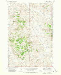
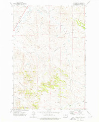 1973 Harris Buttes1976 Print · USGSCuster County in the early 1970s shows a landscape of high buttes and seasonal creek beds typical of eastern Montana. Trace family landmarks and land features like Harris Buttes, Wild Horse Mountain, and the winding path of Pumpkin Creek.
 - 1973 Map of Saddle Horse Butte, 1976 Print
 1973 Saddle Horse Butte1976 Print · USGSCuster County ranching country is mapped here in the early seventies, centered on the landmark of Saddle Horse Butte. Researchers can trace old routes like Powderville Road and locate remote points such as Anderson and the bends of Mizpah Creek.
 - 1973 Map of Carey-Malone School, 1976 Print
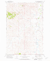
 1973 Carey-Malone School1976 Print · USGSCuster County ranching country is shown in the early 1970s, focused on the remote educational and water infrastructure of the era. Genealogists and local historians can locate the Carey-Malone School and trace the many Well and Spring sites along Foster Creek.
 - 1973 Map of Maxwell Butte, 1976 Print
 1973 Maxwell Butte1976 Print · USGSCuster County ranching country is captured here in the early seventies, showing a landscape defined by its vital water sources and remote roads. Genealogists and historians can trace routes along Powderville Road or locate landmarks like Maxwell Butte and Spring Creek.
 - 1973 Map of North Stacey School, 1976 Print
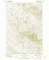
 1973 North Stacey School1976 Print · USGSThe Montana ranching country south of Miles City is captured here during the 1970s. Researchers can locate the North Stacey School and North Stacey Cem, or trace family landmarks like Castle Rock and the waters of Starvation Creek.2 unique versions available
 - 1973 Map of Kirkpatrick Hill, 1976 Print
 1973 Kirkpatrick Hill1976 Print · USGSCuster County ranching country is documented in the 1970s, showing a remote landscape shaped by watercourses and rimrocks. Researchers can locate early rural school sites like Ash Creek Sch, the SY School, and the grounds of the Allen Ranch.
 - 1973 Map of Witcher Reservoir, 1976 Print
 1973 Witcher Reservoir1976 Print · USGSSoutheast Montana's high plains are mapped during the 1970s, showing a remote landscape divided by the Custer and Powder River county line. Genealogists and researchers can trace the winding paths of Mizpah Creek and Big Bobcat Creek or locate the solitary Witcher Reservoir.
 - 1973 Map of Rattlesnake Hill, 1976 Print
 1973 Rattlesnake Hill1976 Print · USGSSoutheastern Montana ranching country is captured here during the early seventies at the boundary of Custer and Powder River counties. Local historians and land researchers can locate isolated water sources like Spring and Well or trace the drainages of Horse Creek and Little Corral Creek.
 - 1973 Map of Divide School, 1976 Print
 1973 Divide School1976 Print · USGSEastern Montana ranching country comes into focus in the early seventies at the border of Custer and Powder River counties. Researchers can locate the Divide School and trace the paths of Sand Creek, Dick Creek, and Bobcat Creek across the plains.
 - 1973 Map of Foster Creek School, 1976 Print
 1973 Foster Creek School1976 Print · USGSIn the early 1970s, this portion of the Montana ranchlands sat at the intersection of Custer and Powder River Counties. Genealogists and researchers can trace local landmarks like Foster Creek School, the Green Ranch, and the settlement of Jandell.
 - 1973 Map of Volborg, 1976 Print
 1973 Volborg1976 Print · USGSSoutheastern Montana's high plains come to life in the early 1970s, centered on the ranching outpost of Volborg. Researchers can trace old water rights and section boundaries along Pumpkin Creek and identify local landmarks like Flat Butte or the Landing Strip.
 - 1973 Map of Fourmile Creek, 1977 Print
 1973 Fourmile Creek1977 Print · USGSEastern Montana ranch lands are captured here in the early 1970s, showcasing a landscape of deep coulees and vital water sources. Trace the path of Tongue River or locate remote wells and springs near Fourmile Creek and Foster Creek Road.
 - 1979 Map of Blacktail Creek NW
 1979 Blacktail Creek NW1979 Print · USGSSoutheast Montana rangeland meets the Powder River in the late seventies, showing a landscape defined by its vital water sources and remote boundaries. Genealogists and researchers can trace local land use through flowing wells, scattered jeep trails, and the convergence of Blacktail Creek and Alkali Creek.
 - 1979 Map of Mills Creek East
 1979 Mills Creek East1979 Print · USGSCuster County ranching country is captured here in the late seventies, showing a landscape shaped by the Powder River. Researchers can locate isolated water sources and early landmarks like Shaw, Jones Reservoir, and Dead Horse Creek.
 - 1979 Map of Blacktail Creek SW
 1979 Blacktail Creek SW1979 Print · USGSSoutheastern Montana ranching country is documented here in the late seventies at the junction of three counties. Genealogists and researchers can trace local routes like Powderville Road or locate water sources at Whitetail Creek and various Spring sites.
 - 1979 Map of Forsyth
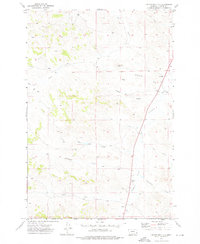
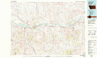 1979 Forsyth1979 Print · USGSThe Yellowstone River valley is captured here in the late seventies, showing a landscape defined by competing rail lines and riverside towns. Researchers can trace the routes of the Burlington Northern, locate the Rosebud State Rec Area, or find old outposts like Hathaway and Sheffield.
 - 1979 Map of Powderville
 1979 Powderville1979 Print · USGSSoutheast Montana ranching country is captured here in the late seventies, centered on the community of Powderville. Local historians and genealogists can locate the Boothill Cem, the Hunt Sch, and landmarks like Soldiers Mount along the Powder River.
 - 1979 Map of Mills Creek West
 1979 Mills Creek West1979 Print · USGSCuster County ranching country is shown in detail during the late 1970s, revealing a landscape shaped by water management. Researchers can trace land features like Love Reservoir, Monarch Creek, and the many Drill Hole sites of the era.
 - 1979 Map of Angela
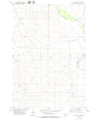
 1979 Angela1979 Print · USGSEastern Montana rangeland at the end of the seventies reveals a vast network of watercourses and isolated ranching outposts. Trace family land near Angela or locate remote landmarks like Steamboat Rock, Dinosaur Dam, and the intersection of four different county lines.
Showing maps 1-25 of 26
Top cities of Custer County
Frequently asked questions
- What are the different types of historical maps available for Custer County?
- What is the oldest map of Custer County?
- Where can I purchase historical maps of Custer County for my home or office?
- Where can I download high-res historical maps of Custer County?
- Are there historical topographic maps available for Custer County?
- Is there historical aerial imagery available for Custer County?
- Where are historical maps of Custer County sourced from?