1980s Maps of Custer County, Montana
Explore 16 historic maps of Custer County from the 1980s. These maps offer a rare glimpse into what life looked like during the 1980s — showing old roads, neighborhoods, homes, and landmarks that have changed or disappeared over time.
Whether you're researching your family's past, planning a metal detecting trip, or studying how Custer County's landscape evolved across the 1980s, these high-resolution maps are a powerful tool for exploring the history of this region.
- Focus on a specific era: All maps on this page are from the 1980s, giving you a focused view of this time period.
- See what’s changed: Compare century-old streets, trails, and buildings to today's modern landscape using overlays and satellite layers.
- Research with precision: Use these maps for genealogy, historical research, land use analysis, or educational projects.
- View, download, or print: Maps are fully viewable online in high resolution, and can be downloaded or printed for your own records.
Start exploring Custer County's history through authentic maps from the 1980s. This is your window into the past.
Custer County, MT maps
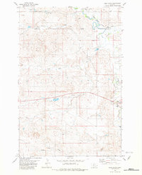
(16)- 1980 Map of Lame Deer
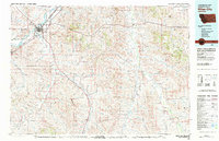
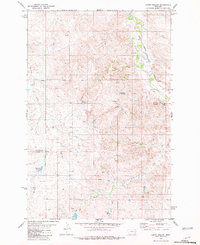
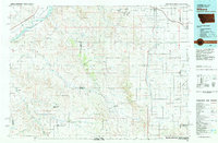
 1980 Lame Deer1980 Print · USGSHigh plains ranching and coal mining define this corner of Montana as the eighties began. Researchers can trace the rail lines of the Burlington Northern and locate sites like Colstrip, Jimtown, and the Big Sky Strip Mine.
 - 1980 Map of Terry, 1981 Print
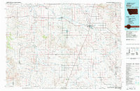
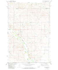
 1980 Terry1981 Print · USGSEastern Montana's rail and river networks are preserved here as they appeared in the early eighties. Genealogists and historians can trace the paths of two major railroads through Terry and Kinsey or locate family landmarks near Broadview Bench and Eagle Butte.
 - 1980 Map of Miles City, 1982 Print
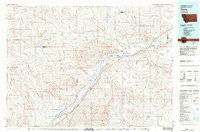
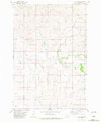
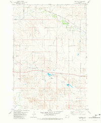
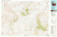
 1980 Miles City1982 Print · USGSCuster County was a vital rail and river corridor in the late 1970s, anchored by the confluence of the Yellowstone River and Tongue River. Researchers can trace the paths of the Burlington Northern railroad and find the Beebe (Site) among the ridges of The Pine Hills.
 - 1981 Map of Baker
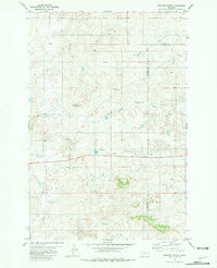
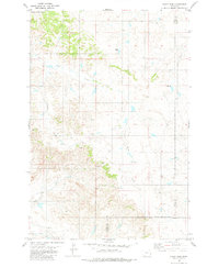
 1981 Baker1981 Print · USGSThe Montana-North Dakota borderlands are captured here in the early 1980s, showcasing the high plains ranching and rail corridor. Genealogists can locate rural landmarks like Lame Jones School and the Milwaukee Road railroad route through Plevna and Ismay.
 - 1981 Map of Bracket Butte
 1981 Bracket Butte1981 Print · USGSEastern Montana ranching country comes into focus at the Custer and Fallon county line in the early eighties. Genealogists can locate family landmarks such as Cottonwood School, Cottonwood Cemetery, and the Mc Kee Well near Bracket Butte.
 - 1981 Map of Loony Hollow
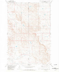
 1981 Loony Hollow1981 Print · USGSEastern Montana ranching country is captured here in the early 1980s along the Milwaukee Road corridor. Genealogists and historians can trace the Prairie-Custer County line or locate isolated landmarks like a lone Grave and Archdale Reservoir.
 - 1981 Map of Ismay North
 1981 Ismay North1981 Print · USGSCuster and Prairie Counties are captured here in the early eighties, centered on the railroad town of Ismay. Researchers can trace the Milwaukee Road line as it follows O'Fallon Creek past local landmarks like the Storage Bin and various Flowing Wells.
 - 1981 Map of Ayer Spring
 1981 Ayer Spring1981 Print · USGSEastern Montana rangeland at the borders of Prairie, Custer, and Fallon counties is documented here in the early eighties. Researchers can trace land use through the network of Well sites and water sources like Ayer Spring and Pennel Creek.
 - 1981 Map of Hooky Dam
 1981 Hooky Dam1981 Print · USGSSoutheastern Montana ranching country is documented here in the early 1980s where Custer, Fallon, and Carter counties meet. Genealogists and local historians can trace land use through landmarks like the Rodeo Ground, Hooky Dam, and Lumpjaw Spr.
 - 1981 Map of Ismay South
 1981 Ismay South1981 Print · USGSThe high plains of Eastern Montana are documented here in the early eighties, showing the critical path of the Chicago Milwaukee St Paul and Pacific railroad. Genealogists and historians can trace water rights and land use through landmarks like Rieger Dam, O'Fallon Creek, and Scroggin Creek.
 - 1981 Map of North Fork Alkali Creek
 1981 North Fork Alkali Creek1981 Print · USGSThe borderlands of Custer and Carter counties come into focus during the early eighties, showing a landscape defined by ranching and resource exploration. Local historians can trace water management sites like Cold Springs Dam and find evidence of industrial survey work at the Drill Hole.
 - 1981 Map of Westmore
 1981 Westmore1981 Print · USGSEastern Montana ranch lands are captured here in the early eighties, centered on the rail-side community of Westmore. Genealogists and historians can trace family land via section lines, located near O'Fallon Creek and the Chicago Milwaukee St Paul and Pacific railroad.
 - 1981 Map of Foundation Spring
 1981 Foundation Spring1981 Print · USGSThe Montana rangelands along the Custer and Fallon County line appear here in the early eighties, defined by essential water sources and livestock infrastructure. Researchers can trace the path of Locate Creek and identify landmarks like Foundation Spring and the local Gravel Pit.
 - 1981 Map of Wibaux, 1982 Print
 1981 Wibaux1982 Print · USGSThe Montana and North Dakota borderlands come into focus in the early 1980s, showcasing a landscape shaped by the BURLINGTON NORTHERN railroad and the Yellowstone River. Researchers can trace the rail corridor through Wibaux and Yates or locate isolated landmarks like Graveyard Hill and Johnstone Dam.
 - 1982 Map of Ekalaka, 1983 Print
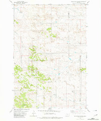
 1982 Ekalaka1983 Print · USGSEastern Montana ranching country and the tri-state border lands are meticulously documented in the early 1980s. Local historians can trace the remote settlement of Ekalaka, the landmarks of Medicine Rocks, and the rugged profiles of Chalk Buttes and Long Pine Hills.
 - 1983 Map of Forsyth
 1983 Forsyth1983 Print · USGSEastern Montana's high plains and river valleys come into focus in the early eighties as the rail-and-ranching economy centered on the Yellowstone River. Researchers can trace the development of small rail towns like Hysham, Angela, and Ingomar alongside the Burlington Northern line.
End of results
Showing maps 1-16 of 16
Top cities of Custer County
Frequently asked questions
- What are the different types of historical maps available for Custer County?
- What is the oldest map of Custer County?
- Where can I purchase historical maps of Custer County for my home or office?
- Where can I download high-res historical maps of Custer County?
- Are there historical topographic maps available for Custer County?
- Is there historical aerial imagery available for Custer County?
- Where are historical maps of Custer County sourced from?