1960s Maps of Fergus County, Montana
Explore 3 historic maps of Fergus County from the 1960s. These maps offer a rare glimpse into what life looked like during the 1960s — showing old roads, neighborhoods, homes, and landmarks that have changed or disappeared over time.
Whether you're researching your family's past, planning a metal detecting trip, or studying how Fergus County's landscape evolved across the 1960s, these high-resolution maps are a powerful tool for exploring the history of this region.
- Focus on a specific era: All maps on this page are from the 1960s, giving you a focused view of this time period.
- See what’s changed: Compare century-old streets, trails, and buildings to today's modern landscape using overlays and satellite layers.
- Research with precision: Use these maps for genealogy, historical research, land use analysis, or educational projects.
- View, download, or print: Maps are fully viewable online in high resolution, and can be downloaded or printed for your own records.
Start exploring Fergus County's history through authentic maps from the 1960s. This is your window into the past.
Fergus County, MT maps
(3)- 1964 Map of Wolf Creek Falls, 1966 Print
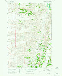 1964 Wolf Creek Falls1966 Print · USGSThe central Montana plains appear in the mid-1960s as a landscape of wide plateaus and deep coulees carved by the Judith River. Researchers can trace the drainage patterns of Wolf Creek Falls or locate the remote Gravel Pit and fencelines.
 - 1964 Map of Anderson Bridge, 1966 Print
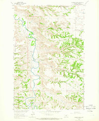 1964 Anderson Bridge1966 Print · USGSThe Judith River cuts through the Fergus County high plains in the mid-1960s, a landscape defined by deep coulees and isolated crossings. Researchers can trace the original river course and find locations like Anderson Bridge, Bear Springs Bench, and Salt Creek.
 - 1964 Map of Spring Coulee, 1966 Print
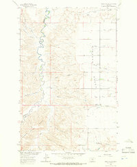 1964 Spring Coulee1966 Print · USGSThe ranching country of Fergus County is captured in the mid-1960s as it straddles the rugged breaks of the Arrow Creek canyon. Genealogists and local historians can trace family ties at the Everson Cem, the Lincoln Sch, and the Everson Community Hall.2 unique versions available
End of results
Showing maps 1-3 of 3
Top cities of Fergus County
- Lewistown historical maps
- Denton historical maps
- Moore historical maps
- Winifred historical maps
- Grass Range historical maps
Frequently asked questions
- What are the different types of historical maps available for Fergus County?
- What is the oldest map of Fergus County?
- Where can I purchase historical maps of Fergus County for my home or office?
- Where can I download high-res historical maps of Fergus County?
- Are there historical topographic maps available for Fergus County?
- Is there historical aerial imagery available for Fergus County?
- Where are historical maps of Fergus County sourced from?