1990s Maps of Creston, Montana
Explore 2 historic maps of Creston from the 1990s. These maps offer a rare glimpse into what life looked like during the 1990s — showing old roads, neighborhoods, homes, and landmarks that have changed or disappeared over time.
Whether you're researching your family's past, planning a metal detecting trip, or studying how Creston's landscape evolved across the 1990s, these high-resolution maps are a powerful tool for exploring the history of this region.
- Focus on a specific era: All maps on this page are from the 1990s, giving you a focused view of this time period.
- See what’s changed: Compare century-old streets, trails, and buildings to today's modern landscape using overlays and satellite layers.
- Research with precision: Use these maps for genealogy, historical research, land use analysis, or educational projects.
- View, download, or print: Maps are fully viewable online in high resolution, and can be downloaded or printed for your own records.
Start exploring Creston's history through authentic maps from the 1990s. This is your window into the past.
Creston, MT maps
(2)- 1991 Map of Creston, 1995 Print
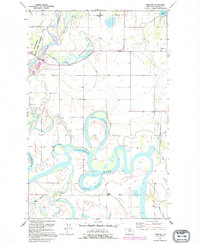 1991 Creston1995 Print · USGSFlathead Valley's intricate network of oxbows and sloughs is captured here during the late twentieth century. Researchers can trace rural school locations like Fairview Sch and Egan Sch or explore the shifting banks of the Flathead River and Egan Slough.
 - 1994 Map of Creston, 1996 Print
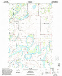 1994 Creston1996 Print · USGSThe Flathead River valley in the mid-1990s reveals a complex landscape of riparian wetlands and rural settlements. Trace local history at the Fair Mont Egan School or follow the intricate oxbows of Egan Slough and Church Slough.
End of results
Showing maps 1-2 of 2
Top cities near Creston
Frequently asked questions
- What are the different types of historical maps available for Creston?
- What is the oldest map of Creston?
- Where can I purchase historical maps of Creston for my home or office?
- Where can I download high-res historical maps of Creston?
- Are there historical topographic maps available for Creston?
- Is there historical aerial imagery available for Creston?
- Where are historical maps of Creston sourced from?