1960s Maps of Kalispell, Montana
Explore 5 historic maps of Kalispell from the 1960s. These maps offer a rare glimpse into what life looked like during the 1960s — showing old roads, neighborhoods, homes, and landmarks that have changed or disappeared over time.
Whether you're researching your family's past, planning a metal detecting trip, or studying how Kalispell's landscape evolved across the 1960s, these high-resolution maps are a powerful tool for exploring the history of this region.
- Focus on a specific era: All maps on this page are from the 1960s, giving you a focused view of this time period.
- See what’s changed: Compare century-old streets, trails, and buildings to today's modern landscape using overlays and satellite layers.
- Research with precision: Use these maps for genealogy, historical research, land use analysis, or educational projects.
- View, download, or print: Maps are fully viewable online in high resolution, and can be downloaded or printed for your own records.
Start exploring Kalispell's history through authentic maps from the 1960s. This is your window into the past.
Kalispell, MT maps
(5)- 1960 Map of Kalispell
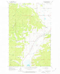
 1960 Kalispell1960 Print · USGSNorthwest Montana in the late fifties is defined by the mountain corridors of the Great Northern Railway and the vast reaches of Glacier National Park. Researchers can trace the legacy of timber and mining towns like Libby, Rexford, and Whitefish, or locate landmarks such as the Snowshoe Mine.
 - 1961 Map of Kalispell
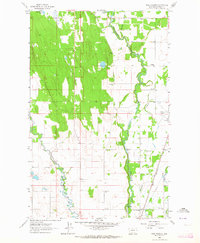
 1961 Kalispell1961 Print · USGSNorthwestern Montana at the start of the 1960s shows a landscape of timber-driven rail towns and the sprawling wild lands of Glacier National Park. Genealogists and historians can trace the route of the Great Northern through mountain passes or locate old settlements like Fortine, Trego, and Warland.
 - 1962 Map of Rose Crossing, 1964 Print
 1962 Rose Crossing1964 Print · USGSFlathead County in the early sixties showcases a landscape defined by river confluences and rural schoolhouses. Researchers can trace the Great Northern line and locate community hubs like Rose Crossing, Midway Grange, and Trinity Cem.3 unique versions available
 - 1962 Map of Blue Grass Ridge, 1964 Print
 1962 Blue Grass Ridge1964 Print · USGSFlathead County ranching and timberlands are captured here in the early sixties as the Smith Valley rural community thrived. Genealogists can trace family holdings and local landmarks like Stillwater Grange, Boorman Sch, and the Spring Creek Cem.3 unique versions available
 - 1962 Map of Kalispell, 1964 Print
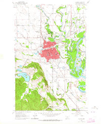 1962 Kalispell1964 Print · USGSKalispell and the surrounding Flathead Valley were expanding in the early sixties as new neighborhoods pushed toward the rivers. Genealogists and local historians can locate several major burying grounds, including Conrad Mem Cem, and trace the rural school system at Demersville Sch or Spring Creek Sch.3 unique versions available
End of results
Showing maps 1-5 of 5
Top cities near Kalispell
Top neighborhoods of Kalispell
- Kalispell South historical maps
- Northwest historical maps
- Southwest historical maps
- Empire Estates historical maps
- Northridge Heights historical maps
- Kalispell North historical maps
See more
Frequently asked questions
- What are the different types of historical maps available for Kalispell?
- What is the oldest map of Kalispell?
- Where can I purchase historical maps of Kalispell for my home or office?
- Where can I download high-res historical maps of Kalispell?
- Are there historical topographic maps available for Kalispell?
- Is there historical aerial imagery available for Kalispell?
- Where are historical maps of Kalispell sourced from?