1990s Maps of Kalispell, Montana
Explore 4 historic maps of Kalispell from the 1990s. These maps offer a rare glimpse into what life looked like during the 1990s — showing old roads, neighborhoods, homes, and landmarks that have changed or disappeared over time.
Whether you're researching your family's past, planning a metal detecting trip, or studying how Kalispell's landscape evolved across the 1990s, these high-resolution maps are a powerful tool for exploring the history of this region.
- Focus on a specific era: All maps on this page are from the 1990s, giving you a focused view of this time period.
- See what’s changed: Compare century-old streets, trails, and buildings to today's modern landscape using overlays and satellite layers.
- Research with precision: Use these maps for genealogy, historical research, land use analysis, or educational projects.
- View, download, or print: Maps are fully viewable online in high resolution, and can be downloaded or printed for your own records.
Start exploring Kalispell's history through authentic maps from the 1990s. This is your window into the past.
Kalispell, MT maps
(4)- 1991 Map of Blue Grass Ridge, 1995 Print
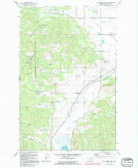 1991 Blue Grass Ridge1995 Print · USGSThe ranching country of Smith Valley is shown here in the 1990s as a community of small rural schools and family-held lands. Genealogists and local historians can trace legacy properties like Keller Ranch or locate burials at Spring Creek Cem and landmarks like Stillwater Grange.
 - 1994 Map of Blue Grass Ridge, 1997 Print
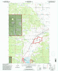 1994 Blue Grass Ridge1997 Print · USGSThe Flathead Valley's ranching and conservation history is preserved here as it appeared in the mid-nineties. Genealogists and local historians can locate family landmarks like Keller Ranch, trace the grounds of Boorman Sch, or explore the protected wetlands of Smith Lake.
 - 1994 Map of Kalispell, 1997 Print
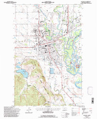 1994 Kalispell1997 Print · USGSKalispell and its river valleys appear in this mid-nineties survey during a period of steady growth and civic development. Genealogists and historians can trace family roots through the Conrad Memorial Cem, the Flathead Co High Sch, and landmarks like the Conrad Mansion.
 - 1994 Map of Rose Crossing, 1997 Print
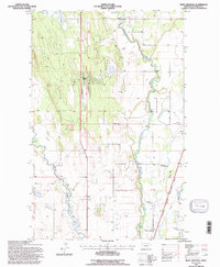 1994 Rose Crossing1997 Print · USGSThe Flathead Valley in the 1990s shows a landscape of river meanders and expanding infrastructure. Trace local development near Happy Valley or find family history at Trinity Cem and the Helena Flats Sch.
End of results
Showing maps 1-4 of 4
Top cities near Kalispell
Top neighborhoods of Kalispell
- Kalispell South historical maps
- Northwest historical maps
- Southwest historical maps
- Empire Estates historical maps
- Northridge Heights historical maps
- Kalispell North historical maps
See more
Frequently asked questions
- What are the different types of historical maps available for Kalispell?
- What is the oldest map of Kalispell?
- Where can I purchase historical maps of Kalispell for my home or office?
- Where can I download high-res historical maps of Kalispell?
- Are there historical topographic maps available for Kalispell?
- Is there historical aerial imagery available for Kalispell?
- Where are historical maps of Kalispell sourced from?