Old Maps of Lake County, Montana for Genealogy
Trace your family roots with 369 historic maps of Lake County. These high-res maps reveal old neighborhoods, homesites, landmarks, and streets — helping you uncover where your ancestors lived and how the area evolved over time.
- Explore historic neighborhoods: Identify where your relatives may have lived in the 1800s or 1900s.
- Compare maps over time: Trace the changes in streets, buildings, and landmarks for multi-generational research.
- Perfect for genealogy & ancestry research: Used by family historians and researchers to map out lineage and migration.
These maps are an incredible resource for exploring your personal connection to Lake County's past.
Lake County, MT maps
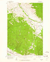
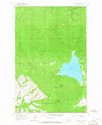
(369)- 1914 Map of Nyack
 1914 Nyack1914 Print · USGSThe Middle Fork Flathead River corridor is captured here during the early days of Glacier National Park. Historians and researchers can trace the Great Northern rail line through remote stops at Nyack, Essex, and Java.3 unique versions available
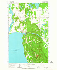
 - 1920 Map of Flathead Lake
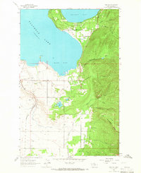
 1920 Flathead Lake1920 Print · USGSWestern Montana at the dawn of the twenties reveals a landscape being transformed by irrigation and rail. Genealogists can trace family roots in early settlements like Polson, Ronan, and Dayton, or locate landmarks such as Wild Horse I. and the Pablo Reservoir.
 - 1921 Map of Elbow Lake
 1921 Elbow Lake1921 Print · USGSThe Montana wilderness near Missoula is captured here during the early 1920s, showcasing the transition of the former reservation lands. Genealogists and hikers can trace early routes like the Gordon Trail and locate historical landmarks such as Gordon Ranch and Holland Lake R.S.
 - 1943 Map of Kalispell
 1943 Kalispell1943 Print · USGSThe Flathead Valley's mid-century rail and river networks are preserved here as Kalispell expanded. Genealogists and historians can trace defunct river crossings like Therriaults Ferry, the old Demersville site, and the rail path of the Somers Kalispell Br.
 - 1955 Map of Choteau, 1978 Print
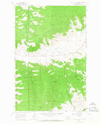
 1955 Choteau1978 Print · USGSWestern Montana during the mid-fifties is captured here as a land of rugged high-country wilderness and vital eastern plains irrigation. Genealogists and historians can locate remote outposts like Condon, the communal Miller Colony, and the rail stops of the Chicago Milwaukee St Paul and Pacific.
 - 1956 Map of Wallace, 1966 Print
 1956 Wallace1966 Print · USGSWestern Montana and the Idaho panhandle meet in this mid-century survey of the Bitterroot and Cabinet Mountains. Genealogists and historians can trace the rail-and-river economy through the Northern Pacific line and settlements like Thompson Falls or St. Ignatius.3 unique versions available
 - 1957 Map of Choteau
 1957 Choteau1957 Print · USGSMontana's mountain front meets the eastern plains in the mid-fifties, showing the transition from forested wilderness to irrigated ranch land. Genealogists and historians can trace the rail lines of the Great Northern and find settlements like Choteau, Augusta, and Seeley Lake.
 - 1957 Map of Kalispell, 1967 Print
 1957 Kalispell1967 Print · USGSNorthwest Montana in the late fifties showcases a mountain landscape transitioning between wilderness and industry. Genealogists and researchers can trace the Great Northern rail corridor through Kalispell and Whitefish, or locate landmarks like the Montana Soldiers Home and Hungry Horse Reservoir.3 unique versions available
 - 1958 Map of Choteau
 1958 Choteau1958 Print · USGSMontana's front range meets the high wilderness in the late fifties, where the Great Northern railway connects ranching towns to the eastern plains. Researchers can trace the development of irrigation at Bynum Reservoir or locate remote camps like the Big Prairie District Ranger Station and Helmville.2 unique versions available
 - 1959 Map of Arlee, 1961 Print
 1959 Arlee1961 Print · USGSThe Flathead Indian Reservation and Jocko River valley are shown here in the late fifties, during a period of established ranching and rail activity. Genealogists and historians can locate family landmarks like Nielson Ranch, the Mission Ch, and the Frenchtown Cem.3 unique versions available
 - 1960 Map of Kalispell
 1960 Kalispell1960 Print · USGSNorthwest Montana in the late fifties is defined by the mountain corridors of the Great Northern Railway and the vast reaches of Glacier National Park. Researchers can trace the legacy of timber and mining towns like Libby, Rexford, and Whitefish, or locate landmarks such as the Snowshoe Mine.
 - 1960 Map of Wallace
 1960 Wallace1960 Print · USGSNorthwestern Montana and the Idaho panhandle are captured in the late fifties, showing the vast Flathead Indian Reservation and the mining districts of the Bitterroot Range. Researchers can trace the rail lines of the Northern Pacific or locate early sites like the Morning Mine and the National Bison Range.
 - 1960 Map of Cut Bank, 1968 Print
 1960 Cut Bank1968 Print · USGSThe high peaks of the Rockies meet the eastern plains in the 1960s, showing the intersection of federal lands and the Blackfeet Indian Reservation. Trace the path of the Great Northern railway and find local landmarks like the Blackfoot Boarding School and Family Mission Cem.3 unique versions available
 - 1961 Map of Kalispell
 1961 Kalispell1961 Print · USGSNorthwestern Montana at the start of the 1960s shows a landscape of timber-driven rail towns and the sprawling wild lands of Glacier National Park. Genealogists and historians can trace the route of the Great Northern through mountain passes or locate old settlements like Fortine, Trego, and Warland.
 - 1962 Map of Choteau
 1962 Choteau1962 Print · USGSThe Rocky Mountain Front meets the western plains in the early 1960s, showing a landscape defined by the Continental Divide. Genealogists and researchers can trace the tracks of the Great Northern and find settlements like Choteau, Augusta, and Bynum.
 - 1962 Map of Bigfork, 1964 Print
 1962 Bigfork1964 Print · USGSThe Flathead Valley and the shores of Bigfork are captured here during the early sixties, showing a landscape of timber management and lakeside settlement. Researchers can locate the Big Fork Dam, the McCaffery Lookout Tower, and local landmarks like Little Brown Ch and Bethany Ch.3 unique versions available
 - 1963 Map of Cut Bank
 1963 Cut Bank1963 Print · USGSNorthern Montana’s mountain passes and high plains are captured here in the early 1960s. Genealogists and historians can trace the Great Northern rail stops from Browning to Ethridge or locate the remote outposts at Polebridge and Babb.
 - 1964 Map of Bull Island
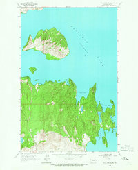
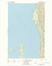 1964 Bull Island1964 Print · USGSFlathead Lake and its eastern shoreline appear here in the mid-1960s, showing the early recreational and tribal land patterns. Trace the unique geography of Finley Point, the islands at The Narrows, and the inlets of Yellow Bay and Blue Bay.4 unique versions available
 - 1964 Map of Cut Bank
 1964 Cut Bank1964 Print · USGSGlacier National Park and the Blackfeet Indian Reservation meet in the early sixties at the triple divide of North America. Researchers can trace the Great Northern Railway through mountain passes and locate local landmarks like the Blackfoot Boarding School and Apgar Village.
 - 1964 Map of Buffalo Bridge
 1964 Buffalo Bridge1964 Print · USGSThe Flathead River valley comes into focus in the mid-sixties, showing the intersection of reservation life and rural development. Trace local community roots at Valley View Sch or follow the water from Loon Lake to the Pablo Canal.2 unique versions available
 - 1964 Map of Wild Horse Island, 1966 Print
 1964 Wild Horse Island1966 Print · USGSFlathead Lake in the mid-1960s reveals a quiet shoreline of isolated camps and rugged island interiors. Trace local landmarks like Lindisfarne (Camp Marshall) and geographical features from White Swan Bay to Wymore Lake.
 - 1964 Map of East Bay, 1966 Print
 1964 East Bay1966 Print · USGSThe southern shores of Flathead Lake come into focus in the mid-1960s, showing a landscape defined by the water and the rising Mission Mountains. Researchers can trace the path of the Northern Pacific railroad or locate features like Finley Point and the Pablo Feeder Canal.2 unique versions available
 - 1964 Map of Irvine Lookout Tower, 1966 Print
 1964 Irvine Lookout Tower1966 Print · USGSThe Hog Heaven Range and the Flathead Indian Reservation are captured here in the mid-1960s. Researchers can locate remote outposts like Hog Heaven Lookout Tower and ranching landmarks such as Pablo Ranch and Bower Ranch.
 - 1964 Map of Dixon, 1966 Print
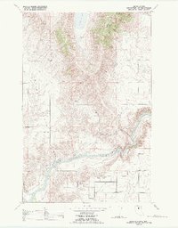
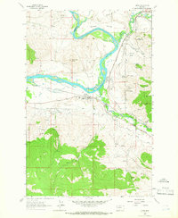 1964 Dixon1966 Print · USGSThe Flathead and Jocko rivers meet in this 1960s survey of the Sanders and Lake County line. Researchers can trace the mid-century rail-and-water economy through features like the Northern Pacific railroad, Dixon Indian Chapel, and the National Bison Range.
 - 1964 Map of Lake Mary Ronan, 1966 Print
 1964 Lake Mary Ronan1966 Print · USGSIn the mid-1960s, the shores of Lake Mary Ronan were surrounded by the timbered slopes of the Flathead National Forest. You can trace old access routes through the Hog Heaven Range and find remote landmarks like Rock Spring and Big Meadows.
Showing maps 1-25 of 369
Top cities of Lake County
Frequently asked questions
- What are the different types of historical maps available for Lake County?
- What is the oldest map of Lake County?
- Where can I purchase historical maps of Lake County for my home or office?
- Where can I download high-res historical maps of Lake County?
- Are there historical topographic maps available for Lake County?
- Is there historical aerial imagery available for Lake County?
- Where are historical maps of Lake County sourced from?