
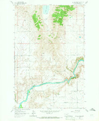
1964 Map of Buffalo Bridge
USGS Topo · Published 1964About this map
The Flathead River carves a deep, winding path through this portion of the Flathead Indian Reservation, where the landscape transitions from the open Ravine Flats to higher elevations. At the center of the local community infrastructure is the Valley View Sch and the Valley View Community Center, which serve as the primary social landmarks in this rural landscape. The map captures a moment of mid-century development under the Bureau of Indian Affairs, detailing the essential water management systems like the Pablo Canal and the northern presence of Loon Lake. Along the river banks, the eponymous Buffalo Bridge and a nearby Substation indicate the points where transportation and utility networks intersect the water. This survey is particularly useful for observing how the land was subdivided and utilized within the reservation boundaries during the 1960s.
Find a feature on this map
13 named features on this map. Tap any name to fly to it.
Don’t see what you’re looking for? This feature index may not catch every label — zoom into the map to look around manually.
Map Details
Editions of this 1964 Buffalo Bridge Map
2 editions found
Other maps of this area

1920 · Flathead Lake
USGS Topo · 1:125,000

1956 · Wallace
USGS Topo · 1:250,000

1960 · Wallace
USGS Topo · 1:250,000

1964 · Wild Horse Island
USGS Topo · 1:24,000

1964 · Irvine Lookout Tower
USGS Topo · 1:24,000

1964 · Elmo
USGS Topo · 1:24,000

1964 · Polson
USGS Topo · 1:24,000

1964 · Lower Crow Reservoir
USGS Topo · 1:24,000

1965 · Oliver Point
USGS Topo · 1:24,000
1965 · Irvine Hill
USGS Topo · 1:24,000