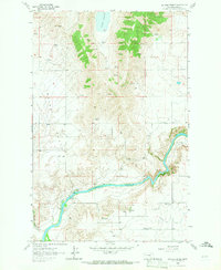
1964 Map of Buffalo Bridge
USGS Topo · Published 1966About this map
The Flathead River snakes through the southern half of this landscape, its steep embankments punctuated by the Buffalo Bridge and the White Bridge. This mid-1960s survey captures a rural Montana landscape within the Flathead Indian Reservation, defined by the contrast between the level Irvine Flats to the west and the numerous natural springs emerging from the rising terrain to the north and east. The concentration of springs around Loon Lake and throughout the higher elevations suggests a critical water network for the local ranching or agricultural operations of the era.
Find a feature on this map
11 named features on this map. Tap any name to fly to it.
Don’t see what you’re looking for? This feature index may not catch every label — zoom into the map to look around manually.
Map Details
Editions of this 1964 Buffalo Bridge Map
2 editions found
Other maps of this area

1920 · Flathead Lake
USGS Topo · 1:125,000

1956 · Wallace
USGS Topo · 1:250,000

1960 · Wallace
USGS Topo · 1:250,000

1964 · Buffalo Bridge
USGS Topo · 1:24,000

1964 · Wild Horse Island
USGS Topo · 1:24,000

1964 · Irvine Lookout Tower
USGS Topo · 1:24,000

1964 · Elmo
USGS Topo · 1:24,000

1964 · Polson
USGS Topo · 1:24,000

1964 · Lower Crow Reservoir
USGS Topo · 1:24,000

1965 · Oliver Point
USGS Topo · 1:24,000