1910s Maps of McCone County, Montana
Explore 7 historic maps of McCone County from the 1910s. These maps offer a rare glimpse into what life looked like during the 1910s — showing old roads, neighborhoods, homes, and landmarks that have changed or disappeared over time.
Whether you're researching your family's past, planning a metal detecting trip, or studying how McCone County's landscape evolved across the 1910s, these high-resolution maps are a powerful tool for exploring the history of this region.
- Focus on a specific era: All maps on this page are from the 1910s, giving you a focused view of this time period.
- See what’s changed: Compare century-old streets, trails, and buildings to today's modern landscape using overlays and satellite layers.
- Research with precision: Use these maps for genealogy, historical research, land use analysis, or educational projects.
- View, download, or print: Maps are fully viewable online in high resolution, and can be downloaded or printed for your own records.
Start exploring McCone County's history through authentic maps from the 1910s. This is your window into the past.
McCone County, MT maps
(7)- 1912 Map of Chelsea
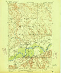
 1912 Chelsea1912 Print · USGSNortheastern Montana at the start of the twentieth century shows the intersection of the Fort Peck Indian Reservation and the Great Plains rail economy. Trace early settlements like Chelsea and Nickwall along the Missouri River and the Great Northern tracks.2 unique versions available
 - 1912 Map of Poplar
 1912 Poplar1912 Print · USGSThe High Plains of northeastern Montana are captured here just before the first World War, centered on the confluence of two major waterways. Genealogists and historians can trace early railroad siding stops like Sprole and Arthur along the Great Northern line and through the Fort Peck Indian Reservation.
 - 1914 Map of Nashua, 1965 Print
 1914 Nashua1965 Print · USGSNortheastern Montana ranching and rail life are captured here in the early twentieth century. Researchers can trace rural school locations like Panton School and Galpin School or locate early family holdings such as Nichols Ranch.
 - 1915 Map of Frazer
 1915 Frazer1915 Print · USGSThe Missouri River valley in the years before the Great War shows a burgeoning rail corridor through the Fort Peck Indian Reservation. Trace the early tracks of the Great Northern and find the small stops at Frazer and Kintyre.3 unique versions available
 - 1915 Map of Oswego
 1915 Oswego1915 Print · USGSNortheast Montana at the height of the homesteading era centers on the Oswego rail stop and the wide Missouri River. Genealogists and historians can trace early land patterns across the Fort Peck Indian Reservation and locate landmarks like Three Buttes and the Great Northern rail line.2 unique versions available
 - 1916 Map of Nashua
 1916 Nashua1916 Print · USGSNortheastern Montana at the height of the homesteading era reveals the vital connection between the rail lines and river valleys. Genealogists and historians can locate early rural schoolhouses like Penton School and Galpin School or trace the Great Northern tracks through Nashua.3 unique versions available
 - 1916 Map of Wolf Point
 1916 Wolf Point1916 Print · USGSWolf Point and the Missouri River valley are captured here in the years before the First World War. Researchers can trace the early railroad corridor of the Great Northern and find rural landmarks like Oldtown, Macon, and the Randolph School.2 unique versions available
End of results
Showing maps 1-7 of 7
Top cities of McCone County
Frequently asked questions
- What are the different types of historical maps available for McCone County?
- What is the oldest map of McCone County?
- Where can I purchase historical maps of McCone County for my home or office?
- Where can I download high-res historical maps of McCone County?
- Are there historical topographic maps available for McCone County?
- Is there historical aerial imagery available for McCone County?
- Where are historical maps of McCone County sourced from?