1900s (20th Century) Maps of Melstone, Montana
Explore 7 historic maps of Melstone from the 1900s (20th Century). These maps offer a rare glimpse into what life looked like during the 1900s — showing old roads, neighborhoods, homes, and landmarks that have changed or disappeared over time.
Whether you're researching your family's past, planning a metal detecting trip, or studying how Melstone's landscape evolved across the 1900s, these high-resolution maps are a powerful tool for exploring the history of this region.
- Focus on a specific era: All maps on this page are from the 1900s, giving you a focused view of this time period.
- See what’s changed: Compare century-old streets, trails, and buildings to today's modern landscape using overlays and satellite layers.
- Research with precision: Use these maps for genealogy, historical research, land use analysis, or educational projects.
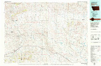
- View, download, or print: Maps are fully viewable online in high resolution, and can be downloaded or printed for your own records.
Start exploring Melstone's history through authentic maps from the 1900s. This is your window into the past.
Melstone, MT maps
(7)- 1954 Map of Forsyth, 1966 Print
 1954 Forsyth1966 Print · USGSThe Yellowstone River valley and the northern high plains are captured here in the mid-1950s during a period of expanding energy and rail infrastructure. Genealogists and historians can trace rail sidings and cattle-country outposts like Ingomar, Vananda, and Angela.3 unique versions available
 - 1957 Map of Forsyth
 1957 Forsyth1957 Print · USGSSouth-central Montana in the late fifties is captured here through its dual-river geography and emergent energy economy. Researchers can trace the path of the Northern Pacific through Forsyth, locate the Ragged Point Oil Field, and find early sidings like Ahles Siding.
 - 1958 Map of Forsyth
 1958 Forsyth1958 Print · USGSMid-century Montana comes alive along the Yellowstone River and the competing transcontinental rail lines. Local historians can trace the legacy of the Northern Pacific through Forsyth or explore early oil developments at the Ragged Point Oil Field.
 - 1962 Map of Queens Point, 1965 Print
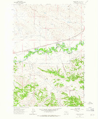 1962 Queens Point1965 Print · USGSCentral Montana’s Musselshell River valley is captured here in the early sixties, showing a landscape defined by the railroad and irrigation. Trace the path of the Chicago Milwaukee St Paul and Pacific near Melstone or find named landmarks like Queens Point.2 unique versions available
 - 1963 Map of Melstone, 1965 Print
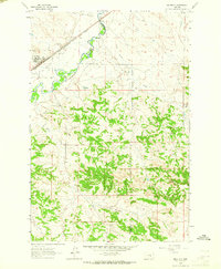 1963 Melstone1965 Print · USGSIn the early sixties, the Musselshell River valley remained a critical corridor for the Milwaukee Road. Trace the rail infrastructure through Melstone and Bascom, alongside water features like Wilson Coulee and Twin Tops.2 unique versions available
 - 1979 Map of Melstone
 1979 Melstone1979 Print · USGSThe ranching and rail corridors of central Montana are preserved in this late 1970s survey. Genealogists and historians can trace the Milwaukee Road through settlements like Melstone, Ingomar, and Sumatra along the Musselshell River.
 - 1983 Map of Forsyth
 1983 Forsyth1983 Print · USGSEastern Montana's high plains and river valleys come into focus in the early eighties as the rail-and-ranching economy centered on the Yellowstone River. Researchers can trace the development of small rail towns like Hysham, Angela, and Ingomar alongside the Burlington Northern line.
End of results
Showing maps 1-7 of 7
Frequently asked questions
- What are the different types of historical maps available for Melstone?
- What is the oldest map of Melstone?
- Where can I purchase historical maps of Melstone for my home or office?
- Where can I download high-res historical maps of Melstone?
- Are there historical topographic maps available for Melstone?
- Is there historical aerial imagery available for Melstone?
- Where are historical maps of Melstone sourced from?