1960s Maps of Richland County, Montana
Explore 22 historic maps of Richland County from the 1960s. These maps offer a rare glimpse into what life looked like during the 1960s — showing old roads, neighborhoods, homes, and landmarks that have changed or disappeared over time.
Whether you're researching your family's past, planning a metal detecting trip, or studying how Richland County's landscape evolved across the 1960s, these high-resolution maps are a powerful tool for exploring the history of this region.
- Focus on a specific era: All maps on this page are from the 1960s, giving you a focused view of this time period.
- See what’s changed: Compare century-old streets, trails, and buildings to today's modern landscape using overlays and satellite layers.
- Research with precision: Use these maps for genealogy, historical research, land use analysis, or educational projects.
- View, download, or print: Maps are fully viewable online in high resolution, and can be downloaded or printed for your own records.
Start exploring Richland County's history through authentic maps from the 1960s. This is your window into the past.
Richland County, MT maps
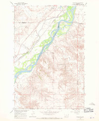
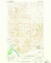
(22)- 1966 Map of Savage, 1970 Print
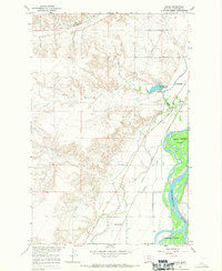
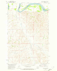
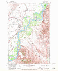 1966 Savage1970 Print · USGSRichland County at the edge of the river bottom in the mid-sixties shows a landscape defined by irrigation and early frontier trails. Genealogists and historians can trace the foundations of Savage, locate the Riverview Cem, and follow the historic Lewis and Clark Trail.2 unique versions available
 - 1966 Map of Crane NE, 1970 Print
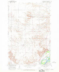
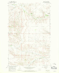 1966 Crane NE1970 Print · USGSRichland County, Montana, was a landscape of high plains ranching and vital rail transport during the mid-sixties. Researchers can trace the path of the Great Northern railway as it skirts Fox Creek or locate local landmarks like the Natural Corral and Vaux Reservoir No 2.
 - 1966 Map of Savage SE, 1970 Print
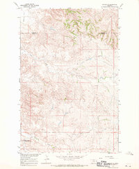 1966 Savage SE1970 Print · USGSEastern Montana's high plains and deep coulees are captured in this mid-century survey of Wibaux County. Researchers can trace the rugged drainage patterns of Dry Creek and Devils Canyon or locate local landmarks like Valentine Flat.
 - 1966 Map of Crane NW, 1970 Print
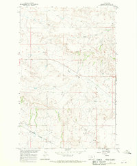 1966 Crane NW1970 Print · USGSRichland County, Montana, is captured in the mid-sixties as a landscape of remote ranchlands and critical water sources. Trace the local geography through family-named landmarks and infrastructure like Getty, the Gravel Pit, and the winding Great Northern Creek.
 - 1966 Map of Savage SW, 1970 Print
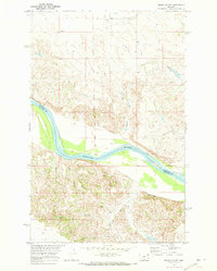
 1966 Savage SW1970 Print · USGSThe Yellowstone River corridor in eastern Montana is captured here in the mid-1960s, showing the intersection of Dawson and Richland counties. Trace the historic Lewis and Clark Trail, the Northern Pacific railroad, and the Main Pacific Canal.
 - 1966 Map of Intake, 1970 Print
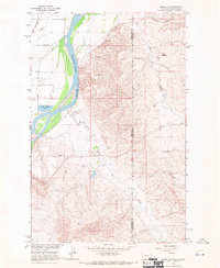
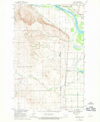
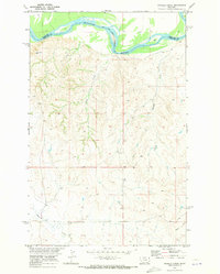
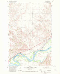 1966 Intake1970 Print · USGSThe Yellowstone River valley in the mid-1960s shows a landscape of coordinated irrigation and rail transport. Researchers can trace the Lewis and Clark Trail past the Diversion Dam and the settlement of Intake.
 - 1966 Map of Piche, 1970 Print
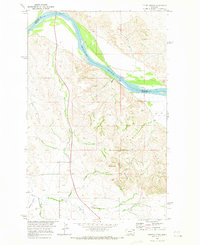
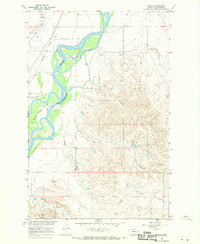 1966 Piche1970 Print · USGSRichland County, Montana, is shown here in the mid-1960s as the Yellowstone River valley supports a rail-and-canal economy. Researchers can trace the Northern Pacific line through Piché or explore the river islands and Main Canal.
 - 1966 Map of Knife River Mine, 1970 Print
 1966 Knife River Mine1970 Print · USGSRichland County, Montana, was a landscape of industrial energy and river-valley agriculture in the mid-1960s. Genealogists and historians can trace the lignite operations at the Knife River Mine and follow the rail corridor through Peabody to the Yellowstone River at Valentine Flat.2 unique versions available
 - 1966 Map of Crane, 1970 Print
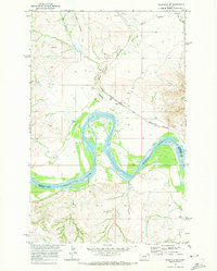
 1966 Crane1970 Print · USGSThe Yellowstone River valley is captured here in the mid-1960s, showing a landscape defined by irrigation and river transport. Trace the historic Lewis and Clark Trail and local landmarks like Crane Cem, Log Ch, and the community of Hoffmanville.
 - 1966 Map of Sidney NE, 1970 Print
 1966 Sidney NE1970 Print · USGSThe Montana and North Dakota border comes alive in the mid-1960s as the Yellowstone River carves through the high plains. Researchers can trace the Great Northern rail line or locate industrial markers like the Thief Mine and McGlynn Dam.2 unique versions available
 - 1966 Map of Skaar NW, 1971 Print
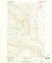
 1966 Skaar NW1971 Print · USGSEastern Montana ranching country is captured here just before the 1970s, right along the NORTH DAKOTA STATE LINE. Genealogists and historians can locate the Clark Sch and trace local water sources like Shadwell Creek and Elm Coulee.
 - 1966 Map of Sidney, 1971 Print
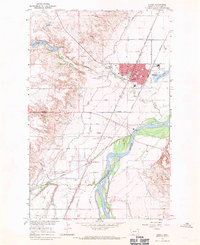 1966 Sidney1971 Print · USGSSidney and the surrounding Richland County plains are captured in the mid-1960s as a thriving rail and agricultural hub. Trace the development of local institutions from St Philomena Sch and the County Fairground to the Newlon Cem.2 unique versions available
 - 1966 Map of Allard Ranch, 1971 Print
 1966 Allard Ranch1971 Print · USGSEastern Montana rangeland near the Dawson and Richland county line is captured here in the mid-sixties. Researchers can trace the development of Allard Ranch and locate specific water sources like Burns Creek and various Spring sites.
 - 1966 Map of Larson School, 1971 Print
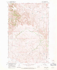
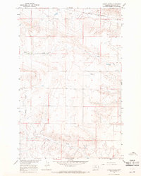 1966 Larson School1971 Print · USGSRichland County's high plains are captured in the mid-1960s, showing a landscape shaped by ranching and rail. Researchers can locate Larson Sch, trace the Great Northern tracks, and follow watercourses like Fox Creek and Crane Creek.
 - 1968 Map of Dore, 1971 Print
 1968 Dore1971 Print · USGSThe Montana-North Dakota borderlands in the late sixties come alive through this survey of the Missouri River confluence. Genealogists and historians can trace the small rail stops of Dore and Nohly alongside the Fort Buford State Historic Site.2 unique versions available
 - 1968 Map of Bainville SE, 1971 Print
 1968 Bainville SE1971 Print · USGSThe Missouri River borderlands at the end of the sixties show a landscape of deep coulees and vital rail lines. Trace the historic grounds of the Fort Union Trading Post, the vanished streets near Mondak Cem, and the tracks of the Great Northern railroad.2 unique versions available
 - 1969 Map of Cedar Coulee, 1973 Print
 1969 Cedar Coulee1973 Print · USGSThe Missouri River Basin in the late sixties shows a landscape of deep coulees and frontier history along the Roosevelt and Richland county line. Genealogists and historians can trace the Old Fort Buford Military Reservation Boundary and locate small operations like Three Mine.2 unique versions available
 - 1969 Map of Culbertson, 1973 Print
 1969 Culbertson1973 Print · USGSCulbertson and the Missouri River bottomlands are captured here in the late sixties as the regional rail and ranching economy thrived. Researchers can find Hillside Cem, the historic Burlington Northern line, and the local Rodeo Ground.2 unique versions available
 - 1969 Map of Twomile Creek, 1973 Print
 1969 Twomile Creek1973 Print · USGSEastern Montana rangeland meets the Missouri River in the late sixties, showing the transition from tribal lands to county territory. Researchers can trace the Fort Peck Indian Reservation Bdy and find local landmarks like Charlie and Devils Elbow.2 unique versions available
 - 1969 Map of Three Buttes, 1973 Print
 1969 Three Buttes1973 Print · USGSRichland County, Montana, was a landscape of deep coulees and river bends at the end of the sixties. Trace the rugged drainage patterns of Hardscrabble Creek or locate the lonely Gaging Sta and Jeep Trail along the Missouri River.2 unique versions available
 - 1969 Map of Bainville SW, 1973 Print
 1969 Bainville SW1973 Print · USGSThe Missouri River bottomlands in the late sixties reveal a landscape of rural industry and transport. Trace family history at Nohly Cem or follow the tracks of the Burlington Northern near Lanark and Lakeside.2 unique versions available
 - 1969 Map of Dugout Creek, 1973 Print
 1969 Dugout Creek1973 Print · USGSThe Missouri River breaks along the Richland and Roosevelt county line in the late sixties. Researchers can trace the winding paths of Hardscrabble Creek and Dugout Creek or locate a high-plains Mine and the landmark known as Boulder.3 unique versions available
End of results
Showing maps 1-22 of 22
Top cities of Richland County
Frequently asked questions
- What are the different types of historical maps available for Richland County?
- What is the oldest map of Richland County?
- Where can I purchase historical maps of Richland County for my home or office?
- Where can I download high-res historical maps of Richland County?
- Are there historical topographic maps available for Richland County?
- Is there historical aerial imagery available for Richland County?
- Where are historical maps of Richland County sourced from?