1930s Maps of Stillwater County, Montana
Explore 5 historic maps of Stillwater County from the 1930s. These maps offer a rare glimpse into what life looked like during the 1930s — showing old roads, neighborhoods, homes, and landmarks that have changed or disappeared over time.
Whether you're researching your family's past, planning a metal detecting trip, or studying how Stillwater County's landscape evolved across the 1930s, these high-resolution maps are a powerful tool for exploring the history of this region.
- Focus on a specific era: All maps on this page are from the 1930s, giving you a focused view of this time period.
- See what’s changed: Compare century-old streets, trails, and buildings to today's modern landscape using overlays and satellite layers.
- Research with precision: Use these maps for genealogy, historical research, land use analysis, or educational projects.
- View, download, or print: Maps are fully viewable online in high resolution, and can be downloaded or printed for your own records.
Start exploring Stillwater County's history through authentic maps from the 1930s. This is your window into the past.
Stillwater County, MT maps
(5)- 1932 Map of Red Lodge No 2
 1932 Red Lodge No 21932 Print · USGSCarbon County ranching country is documented in detail during the early 1930s, showing a landscape organized around mountain streams and rural post offices. Genealogists can locate family-named landmarks and country schools like Inderland Sch, Jackson Sch, and the community at Fishtail.
 - 1932 Map of Red Lodge No 1
 1932 Red Lodge No 11932 Print · USGSCarbon County ranching and early energy infrastructure are on display in this early 1930s survey of the northern Beartooth foothills. Genealogists and historians can trace the rail corridor between Roberts and Boyd or locate industrial sites like the Gas Control Sta.
 - 1932 Map of Nye No 1
 1932 Nye No 11932 Print · USGSStillwater and Carbon counties appear here in the early 1930s, as ranching settlements met the mountain wilderness. Genealogists and local historians can trace the foundations of Fishtail, locate the Dean PO, and follow trails into the Beartooth National Forest.
 - 1932 Map of Nye No 2
 1932 Nye No 21932 Print · USGSStillwater County’s high country comes into focus in the early 1930s, showing the early infrastructure of the national forests. Genealogists and historians can locate the Nye PO, trace the irrigation networks of Horseman Flats, and find remote landmarks like Beartooth Ranch.
 - 1939 Map of Mt Wood, 1941 Print
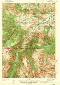 1939 Mt Wood1941 Print · USGSStillwater County comes alive in the late thirties, documenting a rugged mining and ranching frontier within the Custer National Forest. Genealogists and historians can trace local landmarks like Nye, the Benbow Mine, and the Limestone Sch.4 unique versions available
End of results
Showing maps 1-5 of 5
Top cities of Stillwater County
Frequently asked questions
- What are the different types of historical maps available for Stillwater County?
- What is the oldest map of Stillwater County?
- Where can I purchase historical maps of Stillwater County for my home or office?
- Where can I download high-res historical maps of Stillwater County?
- Are there historical topographic maps available for Stillwater County?
- Is there historical aerial imagery available for Stillwater County?
- Where are historical maps of Stillwater County sourced from?