1960s Maps of Stillwater County, Montana
Explore 2 historic maps of Stillwater County from the 1960s. These maps offer a rare glimpse into what life looked like during the 1960s — showing old roads, neighborhoods, homes, and landmarks that have changed or disappeared over time.
Whether you're researching your family's past, planning a metal detecting trip, or studying how Stillwater County's landscape evolved across the 1960s, these high-resolution maps are a powerful tool for exploring the history of this region.
- Focus on a specific era: All maps on this page are from the 1960s, giving you a focused view of this time period.
- See what’s changed: Compare century-old streets, trails, and buildings to today's modern landscape using overlays and satellite layers.
- Research with precision: Use these maps for genealogy, historical research, land use analysis, or educational projects.
- View, download, or print: Maps are fully viewable online in high resolution, and can be downloaded or printed for your own records.
Start exploring Stillwater County's history through authentic maps from the 1960s. This is your window into the past.
Stillwater County, MT maps
(2)- 1965 Map of Bozeman
 1965 Bozeman1965 Print · USGSSouthwestern Montana's river valleys and mountain ranges appear in detail during the early 1960s. Genealogists and historians can trace rail-era settlements like Trident, locate the Anceney School, and see the early footprint of Montana State College.
 - 1969 Map of Laurel, 1970 Print
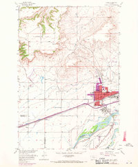 1969 Laurel1970 Print · USGSThe confluence of the Yellowstone and Clarks Fork rivers defines this Montana landscape during the late sixties. Genealogists and researchers can trace the growth of Laurel through its churches, schools like Trewin Sch, and the extensive Burlington Northern rail yards.
End of results
Showing maps 1-2 of 2
Top cities of Stillwater County
Frequently asked questions
- What are the different types of historical maps available for Stillwater County?
- What is the oldest map of Stillwater County?
- Where can I purchase historical maps of Stillwater County for my home or office?
- Where can I download high-res historical maps of Stillwater County?
- Are there historical topographic maps available for Stillwater County?
- Is there historical aerial imagery available for Stillwater County?
- Where are historical maps of Stillwater County sourced from?