1970s Maps of Sweet Grass County, Montana
Explore 7 historic maps of Sweet Grass County from the 1970s. These maps offer a rare glimpse into what life looked like during the 1970s — showing old roads, neighborhoods, homes, and landmarks that have changed or disappeared over time.
Whether you're researching your family's past, planning a metal detecting trip, or studying how Sweet Grass County's landscape evolved across the 1970s, these high-resolution maps are a powerful tool for exploring the history of this region.
- Focus on a specific era: All maps on this page are from the 1970s, giving you a focused view of this time period.
- See what’s changed: Compare century-old streets, trails, and buildings to today's modern landscape using overlays and satellite layers.
- Research with precision: Use these maps for genealogy, historical research, land use analysis, or educational projects.
- View, download, or print: Maps are fully viewable online in high resolution, and can be downloaded or printed for your own records.
Start exploring Sweet Grass County's history through authentic maps from the 1970s. This is your window into the past.
Sweet Grass County, MT maps
(7)- 1972 Map of Battleship Butte, 1975 Print
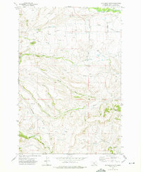 1972 Battleship Butte1975 Print · USGSSweet Grass County ranching country is captured here in the early seventies, showing a landscape defined by its irrigation and water rights. Genealogists and local historians can locate Melville Cem, the Settlement Community Hall, and the prominent Battleship Butte.
 - 1972 Map of Porcupine Butte, 1975 Print
 1972 Porcupine Butte1975 Print · USGSThe high ranchlands of Sweet Grass and Wheatland counties are captured here in the early 1970s. Trace the complex irrigation networks of the Hart Parker Ditch and the lonely Landing Strip near the base of Porcupine Butte.
 - 1972 Map of Loco Mountain, 1976 Print
 1972 Loco Mountain1976 Print · USGSThe Crazy Mountains of Montana come alive in the early 1970s, showcasing a high wilderness of overlapping national forests and county lines. Trace historical access routes via the Pack Trail and Jeep Trail near Lebo Peak and Elk Lake.
 - 1972 Map of Rein Lake, 1976 Print
 1972 Rein Lake1976 Print · USGSSweet Grass and Wheatland counties come together in the early 1970s, showcasing a landscape of high-country ranching and forest preserves. Genealogists and historians can locate the Hopkins Cem and trace early irrigation systems like the Tronrud Ditch near the American Fork Ranch.
 - 1972 Map of Amelong Creek, 1976 Print
 1972 Amelong Creek1976 Print · USGSThe high country of Sweet Grass County in the early seventies is meticulously documented in this backcountry survey. Researchers can trace historic access routes like the Pack Trail and Jeep Trail near Big Timber Guard Station and Half Moon Campground.2 unique versions available
 - 1972 Map of Crazy Peak, 1976 Print
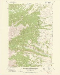
 1972 Crazy Peak1976 Print · USGSThe high ridges and glacial basins of Park and Sweet Grass counties are captured in the early seventies. Trace mountain routes along the Big Timber Canyon Trail and find remote alpine waters like Thunder Rapids Lake and Grasshopper Glacier.3 unique versions available
 - 1979 Map of Big Timber
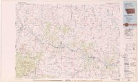 1979 Big Timber1979 Print · USGSThe Yellowstone River valley is the lifeline of this Montana region in the late seventies, where rail and road connect historic river towns. Trace the development of communities like Big Timber and Columbus, or locate rural landmarks like Ross Mine and Riverside Inn.
End of results
Showing maps 1-7 of 7
Top cities of Sweet Grass County
Frequently asked questions
- What are the different types of historical maps available for Sweet Grass County?
- What is the oldest map of Sweet Grass County?
- Where can I purchase historical maps of Sweet Grass County for my home or office?
- Where can I download high-res historical maps of Sweet Grass County?
- Are there historical topographic maps available for Sweet Grass County?
- Is there historical aerial imagery available for Sweet Grass County?
- Where are historical maps of Sweet Grass County sourced from?