1980s Maps of Sweet Grass County, Montana
Explore 18 historic maps of Sweet Grass County from the 1980s. These maps offer a rare glimpse into what life looked like during the 1980s — showing old roads, neighborhoods, homes, and landmarks that have changed or disappeared over time.
Whether you're researching your family's past, planning a metal detecting trip, or studying how Sweet Grass County's landscape evolved across the 1980s, these high-resolution maps are a powerful tool for exploring the history of this region.
- Focus on a specific era: All maps on this page are from the 1980s, giving you a focused view of this time period.
- See what’s changed: Compare century-old streets, trails, and buildings to today's modern landscape using overlays and satellite layers.
- Research with precision: Use these maps for genealogy, historical research, land use analysis, or educational projects.
- View, download, or print: Maps are fully viewable online in high resolution, and can be downloaded or printed for your own records.
Start exploring Sweet Grass County's history through authentic maps from the 1980s. This is your window into the past.
Sweet Grass County, MT maps
(18)- 1985 Map of Upper Glaston Lake
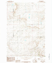
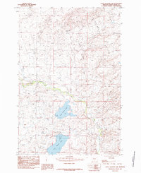 1985 Upper Glaston Lake1985 Print · USGSSweet Grass County in the mid-1980s was a landscape defined by ranching and the management of mountain runoff. Researchers can trace the path of the Upper Sweet Grass Canal and Lower Sweet Grass Canal as they feed into Upper Glaston Lake.
 - 1985 Map of Jim Creek
 1985 Jim Creek1985 Print · USGSThe Montana plains near the three-county corner of Wheatland, Sweet Grass, and Golden Valley are captured here during the mid-1980s. Researchers can trace the varied topography of the Cayuse Hills and the winding paths of Jim Creek and Potato Creek.
 - 1985 Map of Locomotive Butte SW
 1985 Locomotive Butte SW1985 Print · USGSThe triple-border intersection of Golden Valley, Sweet Grass, and Stillwater counties is captured here in the mid-1980s. Researchers can trace the winding paths of Sixshooter Creek and Whitney Creek or locate the prominent rise of Knob Hill.
 - 1985 Map of Gougley Creek
 1985 Gougley Creek1985 Print · USGSSweet Grass County's high-country ranching landscape is captured here in the mid-1980s, revealing the intricate drainage patterns of the Cayuse Hills. Researchers can trace old livestock routes and land markers through Fredrickson Coulee, Sheep Shed Coulee, and Gougley Creek.
 - 1985 Map of Progress
 1985 Progress1985 Print · USGSThe ranchlands of central Montana come into focus in the mid-1980s, centered on the small settlement of Progress. Researchers can trace the winding paths of Fish Creek and Simmons Creek or locate landmarks like Chinemans Hat and the local Gravel Pit.
 - 1985 Map of Melville NW
 1985 Melville NW1985 Print · USGSIn the mid-1980s, the borderlands between Wheatland and Sweet Grass counties remained a landscape of high ridges and winding water. Researchers can trace the drainage of Fish Creek and locate landmarks like the Radio Tower and the settlement of Johnson.
 - 1985 Map of Gibson SW
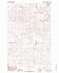
 1985 Gibson SW1985 Print · USGSSweet Grass County ranching country is documented here during the mid-eighties as it appeared before modern development. Researchers can trace the drainages of Sourdough Creek and locate the settlement of Simmons near the Cayuse Hills.
 - 1985 Map of Melville
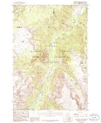
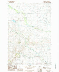 1985 Melville1985 Print · USGSSweet Grass County ranchlands come into sharp focus in the mid-eighties, centering on the settlement of Melville. Researchers can trace the sophisticated irrigation networks of the Upper Sweet Grass Canal and landmarks like Wheeler Butte.
 - 1985 Map of Gibson
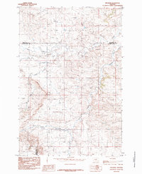
 1985 Gibson1985 Print · USGSGolden Valley and Sweet Grass counties are captured in the mid-1980s, centered on the rural settlement of Gibson. Genealogists and historians can trace the intricate waterways of North Fork Big Coulee Creek and Sixshooter Creek across this high-plains landscape.
 - 1986 Map of Cathedral Point
 1986 Cathedral Point1986 Print · USGSThe Stillwater River valley in the mid-eighties shows a high-country landscape governed by the Absaroka-Beartooth Wilderness. Trace the Pack Trail past Sioux Charley Lake and identify the summits of Cathedral Peak and Twin Peaks.
 - 1986 Map of Meyer Mountain
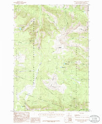
 1986 Meyer Mountain1986 Print · USGSThe high Beartooth wilderness is captured here in the mid-1980s, documenting a landscape shaped by mining and forest management. Researchers can trace historic pack trails and find remote landmarks like Mountain View Lake, Squaw Pass, and the mining site at Limestone.
 - 1986 Map of Pinnacle Mountain
 1986 Pinnacle Mountain1986 Print · USGSThe high Beartooth Range comes into sharp focus in the mid-eighties as three Montana counties meet in a landscape of alpine lakes and peaks. Trace the remote headwaters of the Stillwater River and find isolated landmarks like Lake of the Woods, Pinnacle Mountain, and Horseshoe Basin.
 - 1986 Map of Tumble Mountain
 1986 Tumble Mountain1986 Print · USGSSweet Grass and Stillwater counties are captured here in the mid-1980s, showcasing a high-altitude landscape of glacial lakes and wilderness peaks. Outdoorsmen and researchers can trace the Pack Trail network past Lake Surrender, Chalice Peak, and Wounded Man Lake.2 unique versions available
 - 1986 Map of Picket Pin Mountain
 1986 Picket Pin Mountain1986 Print · USGSSweet Grass County in the mid-1980s reveals a high-country wilderness defined by the Boulder River and the towering Picket Pin Mountain. Researchers can trace old Pack Trails, high-altitude Glaciers, and mineral Prospects near Iron Mountain.
 - 1987 Map of Chrome Mountain
 1987 Chrome Mountain1987 Print · USGSThe Boulder River corridor in southern Montana is shown in the late 1980s as a intersection of wilderness and mineral interest. Researchers can trace the remote infrastructure of the Gallatin National Forest, including the Chrome mine site, Flemming Bridge, and Camp-on-the-Boulder.
 - 1987 Map of Mount Douglas
 1987 Mount Douglas1987 Print · USGSThe high peaks and wilderness river forks of Sweet Grass County are documented here in the late twentieth century. Researchers can trace remote backcountry outposts like Fourmile Guard Station and established sites such as Christikon and Hicks Park Campground.
 - 1987 Map of Haystack Peak, 1988 Print
 1987 Haystack Peak1988 Print · USGSThe high Absaroka Range is captured in the late 1980s, revealing a landscape of remote mining history and protected wilderness. Trace the foundations of Independence and the Independence Mine or locate high-country landmarks like Haystack Peak and Lake Kathleen.
 - 1989 Map of Red Lodge
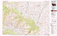 1989 Red Lodge1989 Print · USGSThe Beartooth Mountains and the Montana-Wyoming border come alive in this late 1980s map of the high plateau country. Genealogists and historians can trace the mining history of Bearcreek through the Brophy Mine and Foster Mine or locate the rural Church Hill.
End of results
Showing maps 1-18 of 18
Top cities of Sweet Grass County
Frequently asked questions
- What are the different types of historical maps available for Sweet Grass County?
- What is the oldest map of Sweet Grass County?
- Where can I purchase historical maps of Sweet Grass County for my home or office?
- Where can I download high-res historical maps of Sweet Grass County?
- Are there historical topographic maps available for Sweet Grass County?
- Is there historical aerial imagery available for Sweet Grass County?
- Where are historical maps of Sweet Grass County sourced from?