1900s (20th Century) Maps of Kevin, Montana
Explore 7 historic maps of Kevin from the 1900s (20th Century). These maps offer a rare glimpse into what life looked like during the 1900s — showing old roads, neighborhoods, homes, and landmarks that have changed or disappeared over time.
Whether you're researching your family's past, planning a metal detecting trip, or studying how Kevin's landscape evolved across the 1900s, these high-resolution maps are a powerful tool for exploring the history of this region.
- Focus on a specific era: All maps on this page are from the 1900s, giving you a focused view of this time period.
- See what’s changed: Compare century-old streets, trails, and buildings to today's modern landscape using overlays and satellite layers.
- Research with precision: Use these maps for genealogy, historical research, land use analysis, or educational projects.
- View, download, or print: Maps are fully viewable online in high resolution, and can be downloaded or printed for your own records.
Start exploring Kevin's history through authentic maps from the 1900s. This is your window into the past.
Kevin, MT maps
(7)- 1939 Map of Sunburst, 1941 Print
 1939 Sunburst1941 Print · USGSToole County's oil boom and border-town life are preserved in this late 1930s survey of the northern Montana plains. Trace the early petroleum economy through Ohio Camp and Texas Pacific Camp or find family roots at Willshaw Sch.3 unique versions available
 - 1943 Map of Shelby, 1946 Print
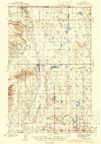
 1943 Shelby1946 Print · USGSToole County ranching and rail life are documented here during the 1940s as the regional economy transitioned between cattle and oil. Genealogists can trace family holdings like Roberts Ranch and Holstad Ranch or locate early rural school sites such as Aloe Sch.2 unique versions available
 - 1954 Map of Shelby, 1967 Print
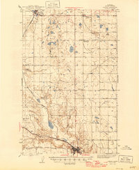
 1954 Shelby1967 Print · USGSNorthern Montana's Hi-Line is captured in the mid-fifties, showing a landscape shaped by the Great Northern rail and early oil development. Trace family roots in Shelby and Conrad, or locate rural landmarks like Goose Bill Butte and the Rocky Boys Indian Reservation.3 unique versions available
 - 1958 Map of Shelby
 1958 Shelby1958 Print · USGSNorthern Montana’s high plains and the Sweetgrass Hills come to life in the late fifties as the Tiber Dam begins to reshape the Marias River valley. Genealogists and historians can trace rail-town lineages along the Great Northern line and locate sites like the Hull Coal Mine or Sweet Grass.
 - 1984 Map of Sweet Grass Hills
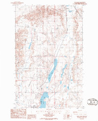
 1984 Sweet Grass Hills1984 Print · USGSThe High Plains of Toole County meet the Canadian border in the early eighties, showcasing a landscape of isolated buttes and essential water coulees. Researchers can trace the Burlington Northern line through Sunburst or locate the Mt Dermott Mine tucked into West Butte.
 - 1986 Map of Kevin North
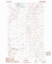
 1986 Kevin North1986 Print · USGSNorthern Montana oil country is captured here in the mid-1980s, centered on the settlements of Sunburst and Kevin. Researchers can trace the extensive OIL FIELD infrastructure, the BURLINGTON NORTHERN line, and a TANK FARM (ABANDONED).
 - 1986 Map of Kevin South
 1986 Kevin South1986 Print · USGSToole County in the mid-eighties shows a landscape deeply integrated with the energy industry and rail transport. Researchers can trace the infrastructure of the Kevin Sunburst Oil Field and Burlington Northern railroad near Potter Ranch.
End of results
Showing maps 1-7 of 7
Top cities near Kevin
Frequently asked questions
- What are the different types of historical maps available for Kevin?
- What is the oldest map of Kevin?
- Where can I purchase historical maps of Kevin for my home or office?
- Where can I download high-res historical maps of Kevin?
- Are there historical topographic maps available for Kevin?
- Is there historical aerial imagery available for Kevin?
- Where are historical maps of Kevin sourced from?