1960s Maps of Glenvil, Nebraska
Explore 4 historic maps of Glenvil from the 1960s. These maps offer a rare glimpse into what life looked like during the 1960s — showing old roads, neighborhoods, homes, and landmarks that have changed or disappeared over time.
Whether you're researching your family's past, planning a metal detecting trip, or studying how Glenvil's landscape evolved across the 1960s, these high-resolution maps are a powerful tool for exploring the history of this region.
- Focus on a specific era: All maps on this page are from the 1960s, giving you a focused view of this time period.
- See what’s changed: Compare century-old streets, trails, and buildings to today's modern landscape using overlays and satellite layers.
- Research with precision: Use these maps for genealogy, historical research, land use analysis, or educational projects.
- View, download, or print: Maps are fully viewable online in high resolution, and can be downloaded or printed for your own records.
Start exploring Glenvil's history through authentic maps from the 1960s. This is your window into the past.
Glenvil, NE maps
(4)- 1969 Map of Hastings East, 1971 Print
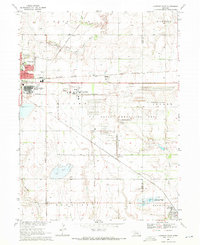 1969 Hastings East1971 Print · USGSThe prairie east of Hastings in the late sixties is dominated by a sprawling defense landscape and rail corridors. Trace the infrastructure of the U S Naval Ammunition Depot (Abandoned) or locate family sites like St Pauls Ch and Inland Cem.
 - 1969 Map of Fairfield NW, 1971 Print
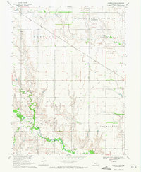 1969 Fairfield NW1971 Print · USGSClay County at the end of the sixties was a landscape of quiet prairie settlements and military remnants. Genealogists and historians can trace the Little Blue River past Spring Ranch Cem and explore the site of the U S Naval Ammunition Depot (Abandoned).
 - 1969 Map of Inland, 1971 Print
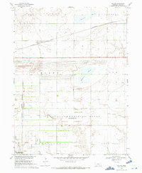 1969 Inland1971 Print · USGSClay County at the end of the 1960s shows a landscape shaped by both agriculture and the massive U S Naval Ammunition Depot (Abandoned). Genealogists can locate several key burial sites including Inland Cem and Zion Cem, or trace the rail routes of the Burlington Northern.
 - 1969 Map of Pauline, 1972 Print
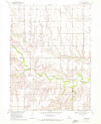 1969 Pauline1972 Print · USGSThe rural agricultural landscapes of south-central Nebraska are captured here in the late sixties, centered on the Little Blue River valley. Genealogists and local historians can trace the foundations of Pauline and locate landmarks like Hanover Ch and School No 75.
End of results
Showing maps 1-4 of 4
Top cities near Glenvil
- Hastings historical maps
- Harvard historical maps
- Blue Hill historical maps
- Clay Center historical maps
- Blaine historical maps
- Fairfield historical maps
See more
Frequently asked questions
- What are the different types of historical maps available for Glenvil?
- What is the oldest map of Glenvil?
- Where can I purchase historical maps of Glenvil for my home or office?
- Where can I download high-res historical maps of Glenvil?
- Are there historical topographic maps available for Glenvil?
- Is there historical aerial imagery available for Glenvil?
- Where are historical maps of Glenvil sourced from?