1970s Maps of Kearney County, Nebraska
Explore 6 historic maps of Kearney County from the 1970s. These maps offer a rare glimpse into what life looked like during the 1970s — showing old roads, neighborhoods, homes, and landmarks that have changed or disappeared over time.
Whether you're researching your family's past, planning a metal detecting trip, or studying how Kearney County's landscape evolved across the 1970s, these high-resolution maps are a powerful tool for exploring the history of this region.
- Focus on a specific era: All maps on this page are from the 1970s, giving you a focused view of this time period.
- See what’s changed: Compare century-old streets, trails, and buildings to today's modern landscape using overlays and satellite layers.
- Research with precision: Use these maps for genealogy, historical research, land use analysis, or educational projects.
- View, download, or print: Maps are fully viewable online in high resolution, and can be downloaded or printed for your own records.
Start exploring Kearney County's history through authentic maps from the 1970s. This is your window into the past.
Kearney County, NE maps
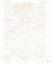
(6)- 1970 Map of Axtell West, 1972 Print
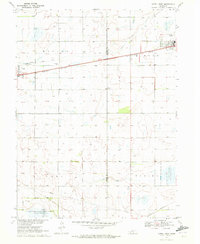 1970 Axtell West1972 Print · USGSThe rural prairie of Phelps and Kearney counties comes into focus in the early 1970s, showcasing the intricate irrigation network of the Mirage Canal. Local researchers can trace the rail corridor of the Burlington Northern through Axtell and Funk, or locate family sites like Fridhem Cem.
 - 1970 Map of Kearney SE, 1972 Print
 1970 Kearney SE1972 Print · USGSSoutheast of Kearney in the 1970s, the Nebraska prairie was defined by a mix of historic military boundaries and modern water engineering. Researchers can trace the Old Fort Kearney Military Reservation Boundary and the path of the Phelps County Canal.
 - 1970 Map of Axtell East, 1972 Print
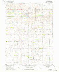
 1970 Axtell East1972 Print · USGSKearney County's agricultural heartland is documented in the early seventies as the rail lines and wildlife areas shaped the local landscape. Researchers can locate family sites near Bethpage Mission, Bethany Ch, or the rural Keene Cem.
 - 1970 Map of Wilcox, 1972 Print
 1970 Wilcox1972 Print · USGSIn the early 1970s, the rural junction of Kearney and Phelps counties featured a landscape of conservation basins and rail corridors. Researchers can locate the Freewater Cem and St Johns Cem, or trace the path of the Burlington Northern and an Old Railroad Grade.
 - 1970 Map of Kearney SW, 1972 Print
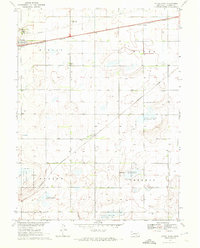
 1970 Kearney SW1972 Print · USGSThe Nebraska plains southwest of Kearney show a landscape of high divides and agricultural engineering during the early seventies. Genealogists can trace property lines near North Creek or locate landmarks like the Aqueduct and Canal in Mirage.
 - 1970 Map of Hildreth, 1972 Print
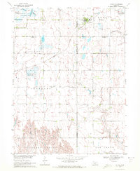
 1970 Hildreth1972 Print · USGSThe rural agricultural landscapes of Franklin and Kearney counties are captured here in the early 1970s. Genealogists can trace family footprints through Hildreth Cem, St Peters Cem, and the small settlement at Moline.
End of results
Showing maps 1-6 of 6
Top cities of Kearney County
- Minden historical maps
- Axtell historical maps
- Wilcox historical maps
- Newark historical maps
- Lowell historical maps
- Heartwell historical maps
See more
Frequently asked questions
- What are the different types of historical maps available for Kearney County?
- What is the oldest map of Kearney County?
- Where can I purchase historical maps of Kearney County for my home or office?
- Where can I download high-res historical maps of Kearney County?
- Are there historical topographic maps available for Kearney County?
- Is there historical aerial imagery available for Kearney County?
- Where are historical maps of Kearney County sourced from?