1960s Maps of Keith County, Nebraska
Explore 4 historic maps of Keith County from the 1960s. These maps offer a rare glimpse into what life looked like during the 1960s — showing old roads, neighborhoods, homes, and landmarks that have changed or disappeared over time.
Whether you're researching your family's past, planning a metal detecting trip, or studying how Keith County's landscape evolved across the 1960s, these high-resolution maps are a powerful tool for exploring the history of this region.
- Focus on a specific era: All maps on this page are from the 1960s, giving you a focused view of this time period.
- See what’s changed: Compare century-old streets, trails, and buildings to today's modern landscape using overlays and satellite layers.
- Research with precision: Use these maps for genealogy, historical research, land use analysis, or educational projects.
- View, download, or print: Maps are fully viewable online in high resolution, and can be downloaded or printed for your own records.
Start exploring Keith County's history through authentic maps from the 1960s. This is your window into the past.
Keith County, NE maps
(4)- 1961 Map of Big Springs, 1963 Print
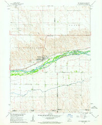 1961 Big Springs1963 Print · USGSSettlement and irrigation define the Nebraska-Colorado borderlands in the early sixties, centered on the South Platte River. Researchers can trace the Union Pacific rail corridor and find local landmarks like the Big Springs Cem and Cottonwood Corner Sch.2 unique versions available
 - 1961 Map of Brule, 1963 Print
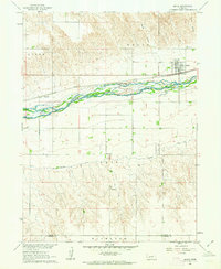 1961 Brule1963 Print · USGSBrule and the surrounding Keith County plains are captured here in the early 1960s as a vital corridor for rail and irrigation. Genealogists and local historians can trace family-named sites like Megeath and School No 61 alongside the winding South Platte River.
 - 1961 Map of Brule SE, 1963 Print
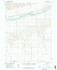 1961 Brule SE1963 Print · USGSIn the early 1960s, the Nebraska plains near the South Platte River remained a landscape of rural schoolhouses and rail-side industry. Genealogists and researchers can trace the locations of School No 9, Searle Airport, and the Union Pacific line.2 unique versions available
 - 1967 Map of North Platte
 1967 North Platte1967 Print · USGSThe Nebraska Sand Hills and the Platte River valley meet in the 1960s, showing a landscape shaped by water management and rail. Genealogists can trace rural school districts like the Prairie Dell School or find landmarks like the Scott Lookout Tower and Geo P Kingsley Dam.
End of results
Showing maps 1-4 of 4
Top cities of Keith County
Frequently asked questions
- What are the different types of historical maps available for Keith County?
- What is the oldest map of Keith County?
- Where can I purchase historical maps of Keith County for my home or office?
- Where can I download high-res historical maps of Keith County?
- Are there historical topographic maps available for Keith County?
- Is there historical aerial imagery available for Keith County?
- Where are historical maps of Keith County sourced from?