1980s Maps of Sioux County, Nebraska
Explore 36 historic maps of Sioux County from the 1980s. These maps offer a rare glimpse into what life looked like during the 1980s — showing old roads, neighborhoods, homes, and landmarks that have changed or disappeared over time.
Whether you're researching your family's past, planning a metal detecting trip, or studying how Sioux County's landscape evolved across the 1980s, these high-resolution maps are a powerful tool for exploring the history of this region.
- Focus on a specific era: All maps on this page are from the 1980s, giving you a focused view of this time period.
- See what’s changed: Compare century-old streets, trails, and buildings to today's modern landscape using overlays and satellite layers.
- Research with precision: Use these maps for genealogy, historical research, land use analysis, or educational projects.
- View, download, or print: Maps are fully viewable online in high resolution, and can be downloaded or printed for your own records.
Start exploring Sioux County's history through authentic maps from the 1980s. This is your window into the past.
Sioux County, NE maps
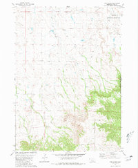
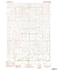
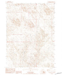
(36)- 1980 Map of Horn, 1981 Print
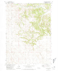
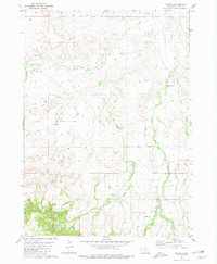
 1980 Horn1981 Print · USGSDawes County in the late 1970s shows a landscape of wide-open ranching country and railroad infrastructure. Genealogists and local historians can trace the community around the Willowdale Sch, the small siding at Horn, and the remote Cem near Benedict Buttes.
 - 1980 Map of Kyle Creek, 1981 Print
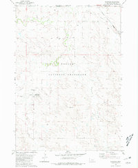
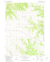
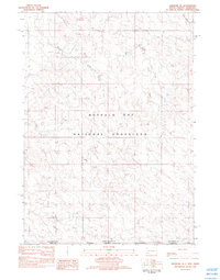
 1980 Kyle Creek1981 Print · USGSIn Sioux County during the 1980s, the White River corridor served as the primary artery for the Chicago and North Western railroad. Trace the local rural infrastructure at Hillview Sch and follow the branching waters of Kyle Creek and Borngrover Creek.
 - 1980 Map of Montrose, 1981 Print
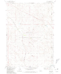
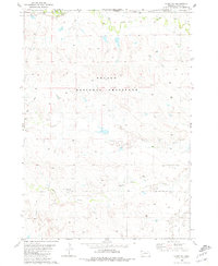
 1980 Montrose1981 Print · USGSSioux County ranching country and frontier history meet in the early eighties at the South Dakota border. Researchers can find the site of Montrose, trace old ranch boundaries like Wasserburger Ranch, and locate the Pioneer Cem or the Warbonnet Battlefield Mon.
 - 1980 Map of Smiley Canyon, 1981 Print
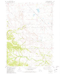
 1980 Smiley Canyon1981 Print · USGSThe Nebraska Panhandle's public lands are on full display in the late 1970s, showcasing the intersection of state parks and national forests. Trace the Chicago and North Western rail line through Smiley Canyon or locate Johnson Lake within Fort Robinson State Park.
 - 1980 Map of Story, 1981 Print
 1980 Story1981 Print · USGSSioux County ranching life in the early eighties is meticulously detailed on this map of the Nebraska-South Dakota borderlands. Researchers can locate established family holdings like the Story Ranch and Locker Ranch amid the sprawling Oglala National Grassland.
 - 1980 Map of Five Points, 1981 Print
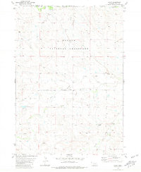
 1980 Five Points1981 Print · USGSSioux County, Nebraska, is shown during the late 1970s, revealing a landscape of high plains ranching and public grasslands. Researchers can trace land use patterns near the Licket Ranch or locate natural landmarks like Five Points and Beans Canyon.
 - 1980 Map of Andrews, 1981 Print
 1980 Andrews1981 Print · USGSSioux County ranching country and federal forest lands are captured here in the early 1980s. Genealogists and local historians can trace the Chicago and North Western rail line through Andrews or locate water sources like Soldier Spring and Tucker Creek.
 - 1980 Map of Orella, 1981 Print
 1980 Orella1981 Print · USGSSioux County, Nebraska, is seen here during the late 1970s as a landscape of isolated ranching outposts and prairie conservation. Genealogists and researchers can trace the rail siding at Orella and landmarks like Sugar Loaf Butte and Twin Butte.
 - 1980 Map of Roundtop, 1981 Print
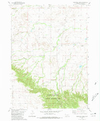
 1980 Roundtop1981 Print · USGSWestern Nebraska rangeland in the late seventies is captured here within the Oglala National Grassland and along the Sioux and Dawes County border. Researchers can locate remote rural institutions and landmarks like Union Star Cem, Roundtop Sch, and Toadstool Park.
 - 1980 Map of Dead Mans Creek, 1981 Print
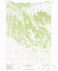
 1980 Dead Mans Creek1981 Print · USGSDawes and Sioux Counties appear here in the early eighties as a landscape of timbered ridges and public land. Researchers can trace the rugged drainages of Dead Mans Creek and Starvation Gulch or locate the Cochran State Wayside Area along the forest boundary.
 - 1980 Map of Story NE, 1981 Print
 1980 Story NE1981 Print · USGSSioux County ranching country is captured here in the early 1980s as it borders South Dakota. Researchers can trace family-named landmarks and water sources like Wasserburger Ranch, Miller Ranch, and the winding Antelope Creek.
 - 1980 Map of Crawford, 1981 Print
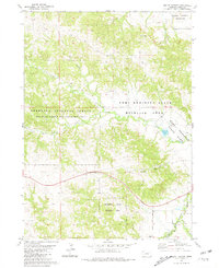
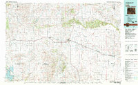
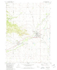 1980 Crawford1981 Print · USGSCrawford served as a vital rail and river junction in the Nebraska panhandle during the early eighties. Researchers can trace the layout of Fort Robinson State Park, locate the St John Cem, and explore landmarks like Lovers Leap Butte.
 - 1980 Map of Warbonnet Ranch, 1981 Print
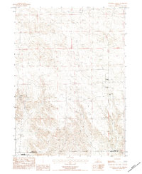
 1980 Warbonnet Ranch1981 Print · USGSSioux County ranching country is captured here during the early 1980s, showing a landscape of high-plains drainages and remote outposts. Researchers can trace land use at Warbonnet Ranch, find the Campground in Monroe Canyon, and follow the winding path of Dirty Jim Creek.
 - 1980 Map of Glen, 1981 Print
 1980 Glen1981 Print · USGSSioux County ranch lands and rail corridors are captured here in the late seventies. Family historians can locate the Glendale Cem and District No 33 Sch along the river valley near the Chicago and North Western railroad.
 - 1980 Map of Bodarc, 1981 Print
 1980 Bodarc1981 Print · USGSSioux County ranching country is captured here in the late twentieth century, showing a landscape of wide-open grazing lands and essential water sources. Genealogists and local historians can locate family landmarks like Wickersham Ranch, Bodarc Sch, and the uniquely named Lady in the Shoe.
 - 1981 Map of Lance Creek, 1983 Print
 1981 Lance Creek1983 Print · USGSEastern Wyoming at the start of the 1980s reveals a high-plains landscape dominated by the energy industry and complex drainage systems. Researchers can trace the footprints of the Kaye Oil Field and Clareton Oil Field or follow the waters of the Cheyenne River and Robbers Roost Creek.
 - 1982 Map of Crowe Dam
 1982 Crowe Dam1982 Print · USGSThe High Plains borderlands of South Dakota and Nebraska are captured here in the early 1980s, showing a vast expanse of open range and federal land. Researchers can trace the drainage of Indian Creek and Coal Creek or locate landmarks like Crowe Dam.
 - 1982 Map of Ardmore
 1982 Ardmore1982 Print · USGSThe South Dakota and Nebraska borderlands come into focus in the early 1980s, centered on the railroad town of Ardmore. Genealogists and historians can trace the local drainage system near Hunter Hill and the vast extent of the Buffalo Gap National Grassland.
 - 1982 Map of Wallace Ranch
 1982 Wallace Ranch1982 Print · USGSThe South Dakota and Nebraska borderlands in the early eighties were a sprawling expanse of open range. Researchers can trace historic ranching sites like Wallace Ranch and Barkley Ranch situated among the drainages of Indian Creek and Alkali Creek.
 - 1982 Map of Ardmore SE
 1982 Ardmore SE1982 Print · USGSThe high plains along the South Dakota and Nebraska border appear in the early 1980s as a vast expanse of public grazing lands. Researchers can trace the drainage patterns of Mule Creek and Hay Creek across the Buffalo Gap National Grassland.
 - 1982 Map of Lusk, 1983 Print
 1982 Lusk1983 Print · USGSNiobrara County and the surrounding high plains are shown in the early eighties as the Chicago and North Western line linked remote cattle towns. Researchers can trace the path of the Niobrara River or locate community hubs like Node, Keeline, and Prairie Center.
 - 1983 Map of University Lake SE, 1984 Print
 1983 University Lake SE1984 Print · USGSSioux and Scotts Bluff counties are shown in the early eighties as a landscape of remote cattle operations and protected prairie. Genealogists and local historians can locate specific family holdings like Prickett Ranch and the various Applegate properties.
 - 1983 Map of Kilpatrick Lake NW, 1984 Print
 1983 Kilpatrick Lake NW1984 Print · USGSThe high plains on the Sioux and Box Butte county line appear here in the early 1980s as a land of expansive cattle operations. Genealogists and local historians can trace legacy family holdings such as the Hood Ranch, Locker Ranch, and I B Henderson Ranch along the winding Snake Creek.
 - 1983 Map of Marsland SW, 1984 Print
 1983 Marsland SW1984 Print · USGSWestern Nebraska's high plains transition into rugged ranchland in the early 1980s. Local history researchers can locate family sites like the Bohemian Pioneer Cem and trace the survey line of Sioux Co Box Butte Co.
 - 1983 Map of Chalk Buttes NE, 1984 Print
 1983 Chalk Buttes NE1984 Print · USGSSioux County ranching country is captured here in the early eighties as a network of creek beds and high-ground markers. Researchers can trace the path of Dry Spottetail Creek or locate utility landmarks like the Radio Tower and Gravel Pit.
Showing maps 1-25 of 36
Frequently asked questions
- What are the different types of historical maps available for Sioux County?
- What is the oldest map of Sioux County?
- Where can I purchase historical maps of Sioux County for my home or office?
- Where can I download high-res historical maps of Sioux County?
- Are there historical topographic maps available for Sioux County?
- Is there historical aerial imagery available for Sioux County?
- Where are historical maps of Sioux County sourced from?