1990s Maps of Sioux County, Nebraska
Explore 5 historic maps of Sioux County from the 1990s. These maps offer a rare glimpse into what life looked like during the 1990s — showing old roads, neighborhoods, homes, and landmarks that have changed or disappeared over time.
Whether you're researching your family's past, planning a metal detecting trip, or studying how Sioux County's landscape evolved across the 1990s, these high-resolution maps are a powerful tool for exploring the history of this region.
- Focus on a specific era: All maps on this page are from the 1990s, giving you a focused view of this time period.
- See what’s changed: Compare century-old streets, trails, and buildings to today's modern landscape using overlays and satellite layers.
- Research with precision: Use these maps for genealogy, historical research, land use analysis, or educational projects.
- View, download, or print: Maps are fully viewable online in high resolution, and can be downloaded or printed for your own records.
Start exploring Sioux County's history through authentic maps from the 1990s. This is your window into the past.
Sioux County, NE maps
(5)- 1990 Map of Carpenter Ranch, 1995 Print
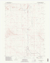 1990 Carpenter Ranch1995 Print · USGSThe high plains of the Nebraska Panhandle meet the Wyoming border in the 1990s, revealing a landscape shaped by ranching and irrigation. Researchers can trace land use through named features like Carpenter Ranch, the Interstate Canal, and several family-named landmarks like Milligan Windmill.2 unique versions available
 - 1990 Map of Torrington SE, 1995 Print
 1990 Torrington SE1995 Print · USGSThe Wyoming and Nebraska borderlands come alive in the 1990s as the North Platte River meets a legacy of westward migration. Trace the historic Emigrant Trail near Hunton Meadows and explore the vast irrigation network of the Interstate Canal.
 - 1990 Map of Lone Sand Hill, 1995 Print
 1990 Lone Sand Hill1995 Print · USGSThe High Plains straddle the state line in the 1990s where the fence lines of Wyoming and Nebraska meet. Researchers can trace the topography surrounding Lone Sand Hill and locate vital water infrastructure like the solitary well near the Goshen County border.
 - 1990 Map of Spoon Butte, 1995 Print
 1990 Spoon Butte1995 Print · USGSThe high plains borderland between Wyoming and Nebraska is shown here as it remained in the early nineties. Genealogists and local historians can trace the topography around Spoon Butte and follow the natural water routes of Sheep Creek and George Draw.
 - 1993 Map of Hot Springs
 1993 Hot Springs1993 Print · USGSThe southern Black Hills and Nebraska borderlands are captured here in the late twentieth century, showing a landscape of national forests and grasslands. You can trace the Black Hills Ordnance Depot near Igloo and follow the Burlington Northern rail lines through Edgemont.
End of results
Showing maps 1-5 of 5
Frequently asked questions
- What are the different types of historical maps available for Sioux County?
- What is the oldest map of Sioux County?
- Where can I purchase historical maps of Sioux County for my home or office?
- Where can I download high-res historical maps of Sioux County?
- Are there historical topographic maps available for Sioux County?
- Is there historical aerial imagery available for Sioux County?
- Where are historical maps of Sioux County sourced from?