Old Maps of Sioux County, Nebraska for Metal Detecting
Plan your next treasure hunt with 264 historic maps of Sioux County. Find old homesites, ghost towns, trails, and gathering spots that may be lost to time — perfect for identifying promising metal detecting locations.
- Locate forgotten sites: Uncover places like long-lost settlements, abandoned rail lines, or gathering spots.
- Plan better hunts: Use map overlays combined with LiDAR or satellite views to narrow in on historically rich areas.
- Made for detectorists: Thousands of hobbyists use these maps to discover relics, coins, and hidden history.
Use these historic maps to boost your research and find new opportunities beneath the surface of Sioux County.
Sioux County, NE maps
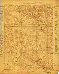
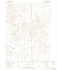
(264)- 1896 Map of Patrick
 1896 Patrick1896 Print · USGSEastern Wyoming ranching life is frozen in time during the mid-1890s, when family-run operations dominated the high plains. Genealogists can trace early homesteads like Nolan's Ranch, Sturdivant's Ranch, and the early settlement at Torrington.7 unique versions available
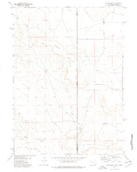
 - 1899 Map of Whistle Creek
 1899 Whistle Creek1899 Print · USGSSioux County's ranching frontier is frozen in time during the late nineteenth century, showing a landscape where water meant survival. Genealogists and historians can trace old wagon routes like the Spottedtail Trail and find early cattle outposts like Agate and Corbin's Ranch.4 unique versions available
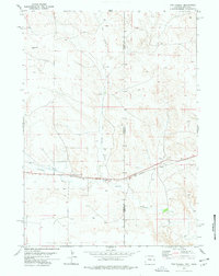
 - 1902 Map of Edgemont
 1902 Edgemont1902 Print · USGSThe Black Hills frontier meets the Nebraska plains at the turn of the century, centered on the rail hub of Edgemont. Trace early settlements and rail stops like Minnekahta, Ardmore, and the Quarry as they appeared in this early 1902 survey.4 unique versions available
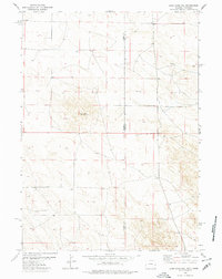
 - 1951 Map of Marsland
 1951 Marsland1951 Print · USGSThe High Plains of Box Butte County are captured here in the early fifties, centered on the railroad town of Marsland. Genealogists and local historians can trace a vanished rural school system through sites like School No 26 and locate family landmarks such as St Marys Ch.3 unique versions available
 - 1951 Map of Kilpatrick Lake
 1951 Kilpatrick Lake1951 Print · USGSIn the mid-century ranchlands of western Nebraska, the landscape is defined by family homesteads and the vital waters of Snake Creek. Researchers can trace the heritage of local estates like Hall Ranch and Henderson Ranch or locate the Severson Cem.2 unique versions available
 - 1954 Map of Torrington, 1963 Print
 1954 Torrington1963 Print · USGSEastern Wyoming and the Nebraska borderlands are captured here during the mid-fifties, showing a landscape shaped by the Platte River and the Laramie Range. Researchers can trace deep history at the Fort Laramie National Historical Site, the Old Doty Ranch Site, and along the Old Fetterman Road.4 unique versions available
 - 1955 Map of Hot Springs, 1958 Print
 1955 Hot Springs1958 Print · USGSThe Black Hills and South Dakota badlands are captured here in the mid-fifties, during a peak of military and industrial activity. Researchers can locate the Black Hills Ordnance Depot, early Uranium Mines, and historic rail stops like Pringle or Oglala.5 unique versions available
 - 1955 Map of Newcastle, 1963 Print
 1955 Newcastle1963 Print · USGSThe high plains of eastern Wyoming and western South Dakota are captured in the mid-fifties, showing a landscape of sprawling ranches and emerging oil fields. Researchers can locate family landmarks like Saunders Ranch, trace the Chicago Burlington & Quincy RR, and explore small rail towns such as Osage and Edgemont.2 unique versions available
 - 1955 Map of Alliance, 1966 Print
 1955 Alliance1966 Print · USGSThe Nebraska panhandle comes into sharp focus during the mid-fifties, showing a landscape defined by the Niobrara River and the expanding Sand Hills. Researchers can trace the grounds of Fort Robinson, locate Saint Marys Church, or follow the Chicago Burlington and Quincy rail line through Hemingford.3 unique versions available
 - 1957 Map of Alliance
 1957 Alliance1957 Print · USGSNorthwest Nebraska in the mid-fifties is captured here as a landscape of rail hubs, sprawling cattle ranches, and the eastern edge of the dunes. Genealogists and historians can trace rail lines through Alliance and Chadron or locate landmarks like Saint Marys Church and the Agate Spring Fossil Beds.
 - 1958 Map of Torrington
 1958 Torrington1958 Print · USGSEastern Wyoming and the Nebraska borderlands are captured in the late fifties, showcasing a landscape of high plains ranching and river-fed industry. Trace the historic paths of the Union Pacific railroad and find legacy sites like Fort Laramie and Sunrise.
 - 1958 Map of Alliance
 1958 Alliance1958 Print · USGSNorthwestern Nebraska in the late fifties shows a landscape shaped by the legacy of the high plains frontier and modern agricultural expansion. Genealogists and historians can trace rail-line settlements and landmarks like Fort Robinson and the Agate Spring Fossil Beds.
 - 1958 Map of Newcastle
 1958 Newcastle1958 Print · USGSThe high plains of eastern Wyoming meet the Black Hills in the late fifties, showcasing a landscape of rail-connected towns and historic trails. Trace the path of the Chicago Burlington & Quincy RR through Newcastle or locate the Bozeman Trail Monument and Summitt Ridge Lookout Tower.
 - 1963 Map of Chalk Buttes, 1965 Print
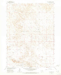 1963 Chalk Buttes1965 Print · USGSSioux County ranching country is captured here during the mid-twentieth century as part of the Missouri River Basin development program. Researchers can locate family landmarks like Hatch Ranch and Spurior Place alongside remote water sources like Goodman Windmill.
 - 1963 Map of Torrington SE, 1965 Print
 1963 Torrington SE1965 Print · USGSThe high plains of the Wyoming-Nebraska border are captured here in the early 1960s, showing the intersection of pioneer history and modern irrigation. Researchers can trace the path of the Emigrant Trail near the North Platte River and locate local sites like Hunton Meadows and Henry.
 - 1963 Map of Erdman Ranch, 1965 Print
 1963 Erdman Ranch1965 Print · USGSHigh plains ranching and intricate canal irrigation meet along the Sioux and Scotts Bluff county line in the early sixties. Genealogists and historians can locate the Erdman Ranch, the Spottedtail Community Hall, and family-named landmarks like the Selby Windmill.
 - 1963 Map of Dry Sheep Creek, 1965 Print
 1963 Dry Sheep Creek1965 Print · USGSSioux and Scotts Bluff counties are shown at the height of their mid-century irrigation boom, where the High Plains were transformed by an expansive canal network. Researchers can trace family-named landmarks like Springer Ranch and rural centers such as Roach and Pleasant Grove Ch.
 - 1963 Map of Carpenter Ranch, 1965 Print
 1963 Carpenter Ranch1965 Print · USGSThe Wyoming and Nebraska high plains are captured here in the early sixties, showing a ranching landscape tied to the state line. Genealogists and historians can locate family outposts like Duncan Place, James, and numerous named water points including Wildy Windmill.2 unique versions available
 - 1963 Map of University Lake, 1965 Print
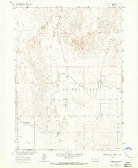
 1963 University Lake1965 Print · USGSSioux County ranching country is captured in the early sixties as the irrigation networks of the High Plains were fully established. Researchers can trace historic family operations like Wind Springs Ranch and F-X Ranch or locate early water features such as University Lake.
 - 1974 Map of Spoon Butte, 1978 Print
 1974 Spoon Butte1978 Print · USGSThe high plains straddling the Wyoming and Nebraska border are captured here in the mid-1970s, showcasing a landscape defined by water and ranching. Genealogists and historians can trace the intersection of Goshen and Sioux counties near Spoon Butte and Sheep Creek.2 unique versions available
 - 1977 Map of Van Tassell, 1978 Print
 1977 Van Tassell1978 Print · USGSThe Wyoming and Nebraska borderlands in the late seventies show a landscape of isolated ranching and rail transport. Genealogists and historians can trace the Chicago and North Western line past Van Tassell and locate the local Cem and Steamboat Rock.
 - 1977 Map of Van Tassell SE, 1978 Print
 1977 Van Tassell SE1978 Print · USGSThe high plains borderland where Wyoming and Nebraska meet is captured in the late 1970s, showcasing a tri-county boundary. Researchers can trace the intersection of Niobrara and Sioux counties alongside local landmarks like a Gravel Pit and numerous Well sites.
 - 1978 Map of Torrington
 1978 Torrington1978 Print · USGSSoutheast Wyoming in the late seventies reveals a landscape shaped by the North Platte River and a dense network of major rail lines. Researchers can locate the Fort Laramie National Historic Site, the Camp Guernsey Training Area, and original stops along the Union Pacific railroad.2 unique versions available
 - 1978 Map of Lone Sand Hill
 1978 Lone Sand Hill1978 Print · USGSThe high plains along the state line between Wyoming and Nebraska come into focus in the late seventies. Researchers can trace land boundaries across Goshen Co and Sioux Co while locating landmarks like the prominent Lone Sand Hill.2 unique versions available
 - 1978 Map of Harrison West, 1979 Print
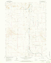
 1978 Harrison West1979 Print · USGSSioux County life in the late 1970s centers on the railroad crossroads of Harrison and the surrounding High Plains. Researchers can trace the Chicago and North Western line, locate the Cem, and see the layout of the County Fairground.
Showing maps 1-25 of 264
Frequently asked questions
- What are the different types of historical maps available for Sioux County?
- What is the oldest map of Sioux County?
- Where can I purchase historical maps of Sioux County for my home or office?
- Where can I download high-res historical maps of Sioux County?
- Are there historical topographic maps available for Sioux County?
- Is there historical aerial imagery available for Sioux County?
- Where are historical maps of Sioux County sourced from?