1960s Maps of Washington County, Nebraska
Explore 7 historic maps of Washington County from the 1960s. These maps offer a rare glimpse into what life looked like during the 1960s — showing old roads, neighborhoods, homes, and landmarks that have changed or disappeared over time.
Whether you're researching your family's past, planning a metal detecting trip, or studying how Washington County's landscape evolved across the 1960s, these high-resolution maps are a powerful tool for exploring the history of this region.
- Focus on a specific era: All maps on this page are from the 1960s, giving you a focused view of this time period.
- See what’s changed: Compare century-old streets, trails, and buildings to today's modern landscape using overlays and satellite layers.
- Research with precision: Use these maps for genealogy, historical research, land use analysis, or educational projects.
- View, download, or print: Maps are fully viewable online in high resolution, and can be downloaded or printed for your own records.
Start exploring Washington County's history through authentic maps from the 1960s. This is your window into the past.
Washington County, NE maps
(7)- 1966 Map of Nickerson, 1967 Print
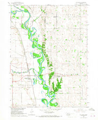 1966 Nickerson1967 Print · USGSThe Elkhorn River valley in the mid-1960s was a critical junction of rail and water, where the Chicago and North Western and Chicago Burlington and Quincy railroads meet. Genealogists can locate family landmarks like Hartung Cem, Immanuel Ch, and several rural schools.
 - 1966 Map of Nickerson NW, 1967 Print
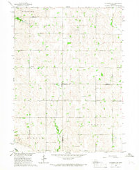 1966 Nickerson NW1967 Print · USGSThe rural borderlands of Dodge, Burt, and Washington counties are captured here in the mid-1960s, showing a landscape of established family farms. Genealogists can trace localized history through numerous country burial sites like Argo Cem and Logan Cem, alongside early district schools such as School No 68.
 - 1968 Map of Fremont East, 1971 Print
 1968 Fremont East1971 Print · USGSThe rail and river networks of eastern Nebraska converged here in the late sixties, showing a period of significant civic and industrial growth. Researchers can trace family roots through numerous neighborhood landmarks like St Patricks Sch, Midland College, and Ruwe Park.3 unique versions available
 - 1968 Map of Kennard, 1971 Print
 1968 Kennard1971 Print · USGSEastern Nebraska farming communities and rail corridors are frozen in time here just before the 1970s. Local historians can trace the Chicago and North Western tracks and locate rural anchors like Sunny Side Sch and the German Cem.
 - 1968 Map of Arlington, 1971 Print
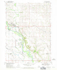 1968 Arlington1971 Print · USGSThe village of Arlington and the fertile Elkhorn River valley are captured here in the late sixties as the local rail and water networks shaped the region. Genealogists can locate family sites near Arlington Cem, School No 43, and along the banks of Rawhide Creek.2 unique versions available
 - 1968 Map of Fort Calhoun, 1971 Print
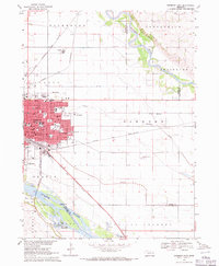
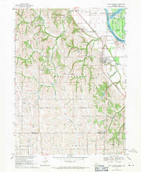 1968 Fort Calhoun1971 Print · USGSThe Missouri River bluffs at Fort Calhoun are captured in the late sixties, showing a landscape of rural schools and riverbottom conservation. Genealogists and local historians can locate the Pioneer Memorial Cem, Wranck Sch, and the Bil-Lo Landing Strip.2 unique versions available
 - 1969 Map of Orum, 1972 Print
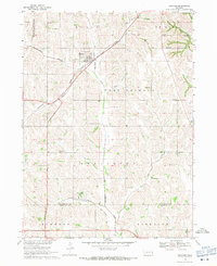
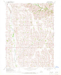 1969 Orum1972 Print · USGSEastern Nebraska farm country is documented here in the late sixties, showcasing the rural life of Herman and Fontanelle. Researchers can trace old family lands near Orum, Spiker, and numerous country school sites like Rose Hill Sch.
End of results
Showing maps 1-7 of 7
Top cities of Washington County
- Blair historical maps
- Arlington historical maps
- Fort Calhoun historical maps
- Kennard historical maps
- Herman historical maps
- Washington historical maps
Frequently asked questions
- What are the different types of historical maps available for Washington County?
- What is the oldest map of Washington County?
- Where can I purchase historical maps of Washington County for my home or office?
- Where can I download high-res historical maps of Washington County?
- Are there historical topographic maps available for Washington County?
- Is there historical aerial imagery available for Washington County?
- Where are historical maps of Washington County sourced from?