1960s Maps of Douglas County, Nevada
Explore 8 historic maps of Douglas County from the 1960s. These maps offer a rare glimpse into what life looked like during the 1960s — showing old roads, neighborhoods, homes, and landmarks that have changed or disappeared over time.
Whether you're researching your family's past, planning a metal detecting trip, or studying how Douglas County's landscape evolved across the 1960s, these high-resolution maps are a powerful tool for exploring the history of this region.
- Focus on a specific era: All maps on this page are from the 1960s, giving you a focused view of this time period.
- See what’s changed: Compare century-old streets, trails, and buildings to today's modern landscape using overlays and satellite layers.
- Research with precision: Use these maps for genealogy, historical research, land use analysis, or educational projects.
- View, download, or print: Maps are fully viewable online in high resolution, and can be downloaded or printed for your own records.
Start exploring Douglas County's history through authentic maps from the 1960s. This is your window into the past.
Douglas County, NV maps
(8)- 1960 Map of Reno
 1960 Reno1960 Print · USGSThe high desert of western Nevada comes alive in this mid-century survey of the Reno-Tahoe region. Genealogists and historians can trace rail lines like the Southern Pacific RR and locate remote outposts such as Olinghouse, Nixon, and the Olinghouse Mine.2 unique versions available
 - 1960 Map of Chico
 1960 Chico1960 Print · USGSThe Northern California high country and Sacramento Valley meet in this 1960s-era landscape of mining towns and river settlements. Trace the rail-and-water economy of the gold country through the Empire Mine, Beale Air Force Base, and the Western Pacific Railroad.
 - 1962 Map of Walker Lake
 1962 Walker Lake1962 Print · USGSThe high desert of western Nevada and the Sierra Nevada crest meet in this mid-century study of the Eastern Sierra frontier. Researchers can trace the Southern Pacific rail lines connecting Hawthorne to remote mining outposts like Bodie, Aurora, and Mina.
 - 1964 Map of Walker Lake
 1964 Walker Lake1964 Print · USGSThe high desert and the Sierra Nevada peaks come together in the mid-1960s, showing a landscape defined by mining, military installations, and vast wilderness. Genealogists and historians can trace the remnants of old mining camps at Bodie or Candelaria and follow the Southern Pacific rail lines.2 unique versions available
 - 1968 Map of McTarnahan Hill, 1971 Print
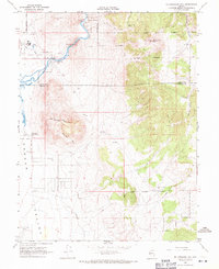 1968 McTarnahan Hill1971 Print · USGSThe Carson River corridor south of the state capital is captured here in the late sixties as industrial sites and institutional lands expanded. Researchers can trace land allotments, the Nevada State Medium Security Prison, and historic sites like Saratoga Hot Spring.4 unique versions available
 - 1968 Map of Minden, 1971 Print
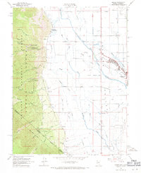 1968 Minden1971 Print · USGSThe Carson Valley in the late 1960s reveals a landscape defined by ranching and the intricate irrigation of the East Fork Carson River. Researchers can locate historic burial sites like Captain George Cem and trace the paths of old agricultural sloughs and the mountain ascent of Kingsbury Grade.6 unique versions available
 - 1968 Map of Genoa, 1972 Print
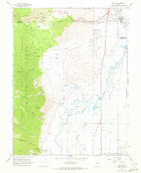 1968 Genoa1972 Print · USGSGenoa and the Carson River valley are captured here in the late sixties, where the high Sierra meets the Nevada desert floor. Genealogists and historians can trace local landmarks like the Stewart Indian School, the Genoa Cem, and the Nevada State Prison Railroad.3 unique versions available
 - 1969 Map of Gardnerville, 1971 Print
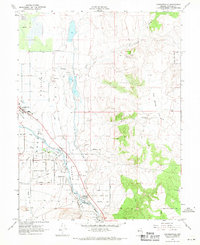 1969 Gardnerville1971 Print · USGSGardnerville and the surrounding valley are shown during a period of steady growth in the late sixties. Genealogists and historians can trace the intricate irrigation network of the East Fork Carson River and locate family homes near Dresslerville or Buckeye.3 unique versions available
End of results
Showing maps 1-8 of 8
Top cities of Douglas County
- Gardnerville Ranchos historical maps
- Johnson Lane historical maps
- Indian Hills historical maps
- Minden historical maps
- Kingsbury historical maps
- Topaz Ranch Estates historical maps
See more
Frequently asked questions
- What are the different types of historical maps available for Douglas County?
- What is the oldest map of Douglas County?
- Where can I purchase historical maps of Douglas County for my home or office?
- Where can I download high-res historical maps of Douglas County?
- Are there historical topographic maps available for Douglas County?
- Is there historical aerial imagery available for Douglas County?
- Where are historical maps of Douglas County sourced from?