1980s Maps of Douglas County, Nevada
Explore 14 historic maps of Douglas County from the 1980s. These maps offer a rare glimpse into what life looked like during the 1980s — showing old roads, neighborhoods, homes, and landmarks that have changed or disappeared over time.
Whether you're researching your family's past, planning a metal detecting trip, or studying how Douglas County's landscape evolved across the 1980s, these high-resolution maps are a powerful tool for exploring the history of this region.
- Focus on a specific era: All maps on this page are from the 1980s, giving you a focused view of this time period.
- See what’s changed: Compare century-old streets, trails, and buildings to today's modern landscape using overlays and satellite layers.
- Research with precision: Use these maps for genealogy, historical research, land use analysis, or educational projects.
- View, download, or print: Maps are fully viewable online in high resolution, and can be downloaded or printed for your own records.
Start exploring Douglas County's history through authentic maps from the 1980s. This is your window into the past.
Douglas County, NV maps
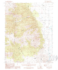
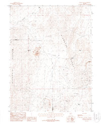
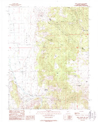
(14)- 1985 Map of Smith Valley
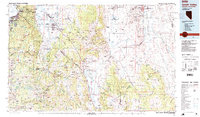 1985 Smith Valley1985 Print · USGSThe Nevada-California borderlands are captured here in the mid-1980s, showcasing the high-desert valleys and Sierra peaks. Trace the mining history at Leviathan Mine or explore the early communities of Minden, Wellington, and the Washoe Indian Res.2 unique versions available
 - 1986 Map of Pine Nut Valley, 1987 Print
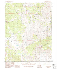
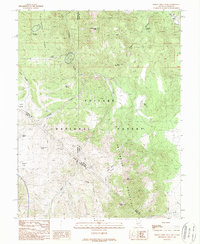
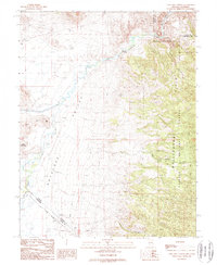
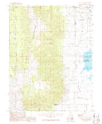 1986 Pine Nut Valley1987 Print · USGSThe Pine Nut Mountains and the edge of Smith Valley are captured here during the mid-1980s, showcasing a landscape of high-desert mining and wildlife management. Researchers can locate specific sites like Slaters Mine, the Blue Danube Mine, and the wetlands surrounding Artesia Lake.
 - 1986 Map of Artesia Lake, 1987 Print
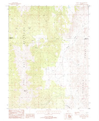
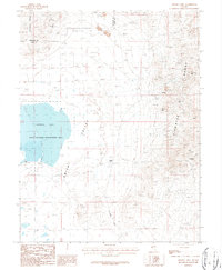 1986 Artesia Lake1987 Print · USGSThe western Nevada mining landscape is preserved here during the mid-1980s, showing the intersection of heavy industry and wildlife conservation. Researchers can trace the heritage of old operations at Ludwig, the Delphi (Site), and the Guild-Bovard Mine.
 - 1986 Map of Mount Siegel, 1987 Print
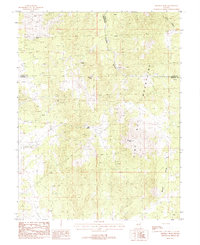
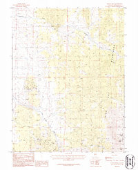 1986 Mount Siegel1987 Print · USGSThe high peaks of the Pine Nut Mountains are recorded here in the mid-1980s during a period of renewed mineral exploration. Geologists and local historians can trace legacy workings at the Monarch Mine, Cherokee Mine, and numerous prospects along Buckeye Creek.
 - 1986 Map of Oreana Peak, 1987 Print
 1986 Oreana Peak1987 Print · USGSWestern Nevada in the mid-1980s reveals a landscape of high-altitude mining prospects and valley irrigation. Genealogists and historians can trace the development of Wellington and Simpson or locate family-named landmarks like Jack Wright Summit and Taylor Hill.
 - 1986 Map of Double Spring, 1987 Print
 1986 Double Spring1987 Print · USGSMining history in the western Pine Nut Mountains comes to life in this mid-eighties record of Douglas County. Prospectors and genealogists can trace the location of silver and gold claims like the Ruby Hill Mine, Bullionville, and Pikes Peak Mine amidst the high desert peaks.
 - 1987 Map of Mount Como, 1988 Print
 1987 Mount Como1988 Print · USGSThe high desert country of the Pine Nut Mountains is captured here in the late eighties, showing a landscape defined by mining and utility expansion. Researchers can trace the trails to Sunrise Camp and identify several remote prospect sites near Mount Como.2 unique versions available
 - 1987 Map of Mineral Peak, 1988 Print
 1987 Mineral Peak1988 Print · USGSThe Pine Nut Mountains and the high-desert borderlands of Carson City and Douglas County are captured here in the late eighties. Researchers can locate numerous mining prospects and historical workings such as the Jane Ellen Mine and the Utopian Mine.3 unique versions available
 - 1988 Map of Lincoln Flat
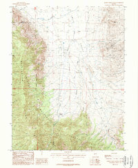
 1988 Lincoln Flat1988 Print · USGSThe high ridges of the Singatse and Buckskin ranges are documented here in the late eighties during a period of active mineral survey. Researchers can trace the layout of the Minnesota Mine, locate remote water sources like Churchill Well, and follow trails through Gallagher Pass.2 unique versions available
 - 1988 Map of Desert Creek Peak, 1989 Print
 1988 Desert Creek Peak1989 Print · USGSThe high Sierra borderlands are captured here in the late eighties, spanning the rugged divide between Nevada and California. Local historians can trace early land use through markers like the Sulfur (Site), a remote Grave, and high-country landmarks like Middle Sister.
 - 1988 Map of Desert Creek Ranch, 1989 Print
 1988 Desert Creek Ranch1989 Print · USGSLyon County ranching and mining come together in the late 1980s as the high-desert landscape shifts from irrigated valleys to mountain forests. Search for old mineral claims like the Smith Valley Mine, the historic Desert Creek Ranch, and the complex Plymouth Canal system.
 - 1988 Map of Topaz Lake, 1989 Print
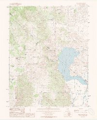 1988 Topaz Lake1989 Print · USGSThe high-desert border between Nevada and California comes alive in this late-eighties survey of Topaz Lake. Genealogists and historians can trace the Von Schmidt Boundary and locate early infrastructure like the Willard-McDonald Mine and Wiley Ditch.2 unique versions available
 - 1988 Map of Risue Canyon, 1989 Print
 1988 Risue Canyon1989 Print · USGSThe high desert borderlands of Nevada and California are captured here in the late 1980s, centered on the Walker River. Local historians can trace mining activity at the Arrowhead Mine and Lilly Mine or locate the site of Camp Antelope.
 - 1988 Map of Long Dry Canyon, 1989 Print
 1988 Long Dry Canyon1989 Print · USGSAntelope Valley sits at the intersection of Nevada and California in the 1980s, where the West Walker River meets high-desert rangeland. Trace historic water rights and land borders along the Von Schmidt Boundary, Hoye Bridge, and the Hoye Canyon Canal.
End of results
Showing maps 1-14 of 14
Top cities of Douglas County
- Gardnerville Ranchos historical maps
- Johnson Lane historical maps
- Indian Hills historical maps
- Minden historical maps
- Kingsbury historical maps
- Topaz Ranch Estates historical maps
See more
Frequently asked questions
- What are the different types of historical maps available for Douglas County?
- What is the oldest map of Douglas County?
- Where can I purchase historical maps of Douglas County for my home or office?
- Where can I download high-res historical maps of Douglas County?
- Are there historical topographic maps available for Douglas County?
- Is there historical aerial imagery available for Douglas County?
- Where are historical maps of Douglas County sourced from?